
|
ANOTHER FAIRLY NICE DAY: Temperatures will rise into the mid to upper 70s across North Texas today with a mostly cloudy sky. The average high for the 29th of March for DFW is 72°. We could see at least some rain at times throughout the day through Saturday morning with an approaching cold front. Any showers we see today will mostly stay clustered, isolated, and few and far between. THE WEEKEND: Clouds will stay in place tomorrow, and most of the day will be dry with only isolated showers in the morning. We turn sharply colder with afternoon highs in the low 60s. A high pressure builds to the north as a cold front pushes to the southeast. Sunday will be much drier with more sun. Highs will still be in the mid to upper 50s, though. NEXT WEEK: Monday and Tuesday morning will be chilly with temperatures dropping to the low 40s, some of the colder pockets could see 30s. The weather will stay dry for a majority of the week with highs gradually increasing. Clouds and rain chances will increase by the latter half of the week as a low forms off the Atlantic coast and moves west. Highs will stay in the mid 70s for the latter half of the week. See the Texas Weather Discussion Video for more details. 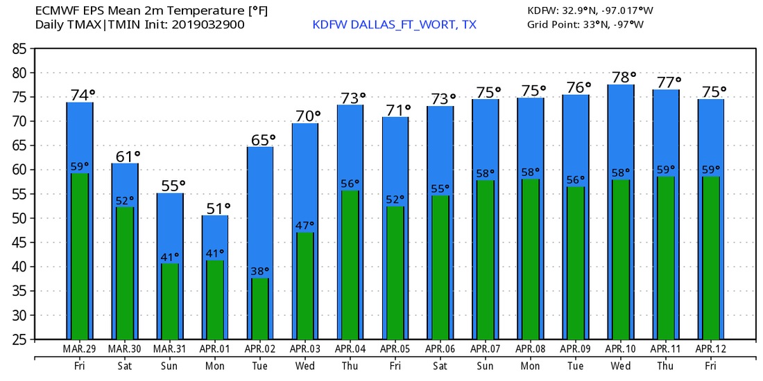 SUN SUN SUN - The sky is mostly clear across North Texas and much of the eastern US this morning. Temperatures are in the upper 50s to low 60s this afternoon. Today will be mostly clear and windy once again with temperatures in the middle to upper 70s. Tonight will be clear again with overnight lows in the low 60s. Clouds will increase Friday morning, then we start mentioning the chance of isolated showers and a couple of storms by the afternoon, persisting through Saturday morning. This will not be an all day rain event, just some rain and lightning at times. Very light rain amounts is expected, and afternoon highs will be in the upper 70s. THE WEEKEND - A well advertised cold front moves through the region early Saturday morning, which will keep us in the low 60s with clouds for much of the day. Once the front moves through during the overnight hours, expect some clearing by Sunday with a transition to sunny skies by that time. A high pressure in the Central Plains will push some cold air into the state, and we should stay in the middle 50s as a result. NEXT WEEK - The first couple of days of April look dry with highs mostly in the 60s and 70s before we introduce the chance of a few showers by the latter half of the week. Highs will still stay in the 70s for much of the week. See the Texas Weather Discussion Video for more details. 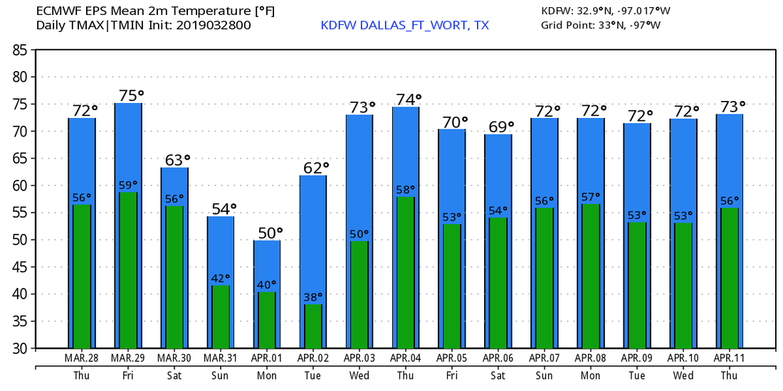 ON THIS DAY IN 2007: A classic Plains tornado outbreak occurred over the High Plains from South Dakota all the way to central Texas and the Texas Panhandle where most of the tornadoes occurred. This tornado outbreak produced 80 tornadoes, including 3 EF3 tornadoes over the Texas Panhandle. One person was killed in the Hemphill county storm, when they were in a trailer when the tornado came through. The two trailers were blown 30-40 yards away, killing a person inside of the trailer. Several other tornadoes were confirmed in South Dakota, Nebraska, Kansas, Colorado, and Oklahoma.
COOL MORNING: As expected, some of the cooler pockets have reached the mid to upper 50s this morning. Today will continue to feature seasonal temperatures with afternoon highs in the in the mid 70s with a mostly sunny sky. Tomorrow will be cloudy for most of the day with highs once again in the mid 70s.
FRIDAY AND THE WEEKEND: Most of the day Saturday should be mostly cloudy, warm, and windy. We will reach the upper 70s by the afternoon. Then, ahead of a cold front, a band of isolated showers and thunderstorms will arrive late Friday evening with rain persisting through early Saturday morning. It looks like isolated showers at times will be possible from around 10:00 AM to 10:00 Saturday morning. At this point, any great risk for severe weather should stay confined to Oklahoma, and rain amounts should stay under 1/4 inch. With a cold front passing by, Saturday should feature highs mostly in the low 60s, followed by mid to upper 50s by Sunday with mostly cloudy skies. NEXT WEEK: We will trend towards more of the same seasonal weather. Highs will be in the 60s early next week followed by low 70s by the latter half of the week. CALMER DAY: We still have a few lingering showers ongoing across the southeastern portions of North Texas early this morning; those will end over the next few hours, and by the afternoon, rain should be confined to the southern part of the state. We turn mostly sunny later today with highs in the low 70s later this afternoon. TUESDAY THROUGH THURSDAY: Not much change. We continue to forecast cool nights and warm, spring days with afternoon highs in the low to mid 70s and morning lows in the 50-60 degree range. The sky remains mostly sunny on both days with a few clouds returning by Thursday. FRIDAY AND THE WEEKEND: Another cold front approaches the southern plains region by this Friday, with a surface low positioned somewhere in the Oklahoma Panhandle. With favorable thermodynamics for severe weather, normally we would go ahead and mention a chance of severe storms, however, a strong "cap", or a 'lid' to prevent storms from intensifying, will mitigate any chances of seeing severe storms for now. For now, we will introduce a small chance of scattered showers and storms Friday evening through Saturday morning. The high on Friday will be in the upper 70s. Once the rain moves through Saturday morning, we will deal with cool air from the cold front. Highs will be in the low 60s on Saturday and Sunday, featuring mostly cloudy skies. NEXT WEEK: It looks like much of next week will also consist of mostly sunny and spring like conditions with gradually warmer temperatures throughout the week. At least the early part of next week looks dry. See the Texas Weather Discussion Video for more details. 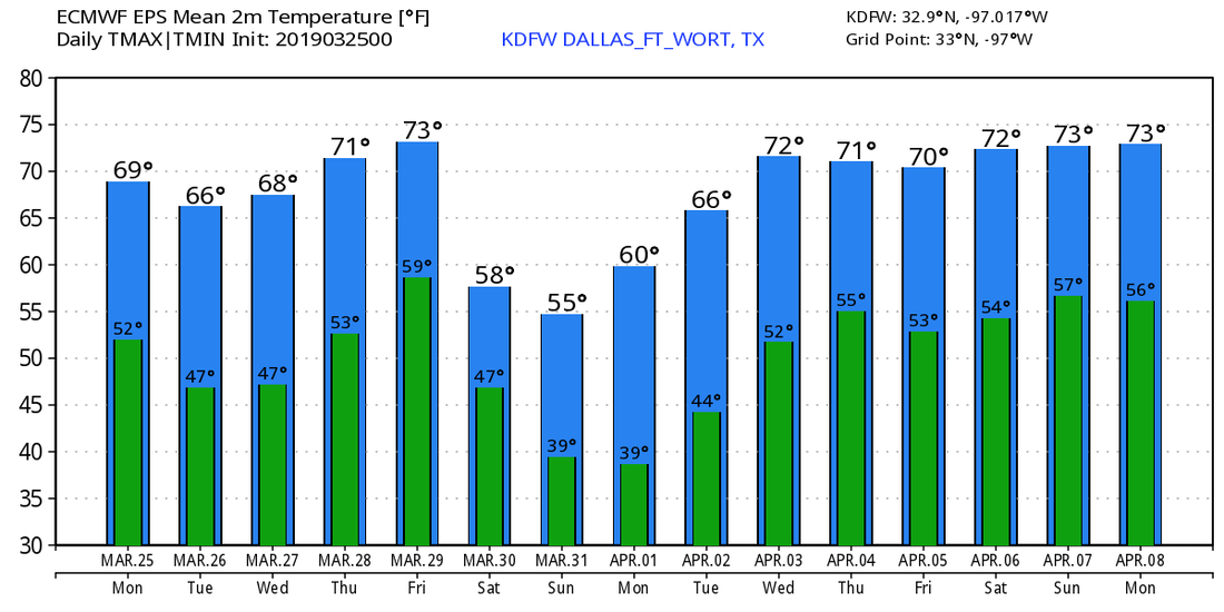 *been very busy on a time crunch, so no Texas Weather Discussion Video today ):* CLOUDS STICKING THROUGH THE DAY: We will continue to see widespread thin cloud cover across North Texas today, and I wouldn't be shocked if we see a shower or two during the day as moisture levels continue to increase. We will warm a few degrees during the late afternoon hours. After the storms tomorrow morning, we transition to spring-like weather with mostly sunny, breezy conditions. Tomorrow's high will be in the mid to upper 70s.  STRONG TO SEVERE STORMS POSSIBLE TONIGHT INTO TOMORROW MORNING: Another vigorous storm system will develop in the Central Plains and move toward the Great Lakes this weekend, with support from troughing. Combining this with moist, unstable air coming from the Gulf of Mexico will result in the risk of severe storms impacting the south-central and south-eastern United States over the course of tonight throughout the weekend. In North Texas, this evening will continue to stay mild with highs in the mid to upper 70s, but the main threat of strong to severe storms will come during the overnight hours into Saturday morning. The latest Day One Convective Outlook from the SPC (Storm Prediction Center) outlines much of North Texas in the standard "slight risk" (level 2 of 5) of severe weather. More specifically, from Fayetteville, Arkansas through Mason, Texas. A "marginal risk" of severe storms generally surrounds the standard risk area from southern Missouri through areas just to the south of Interstate 10. Keep in mind that this convective outlook is valid until 6:00 AM Saturday morning.  TIMING: The main window for strong to severe storms across North Texas will come from 1:00 AM tomorrow through 6:00 AM. The higher resolution models suggest that a batch of rain will start over West Texas and the Panhandle and will intensify into strong/severe storms as upper air forcing starts kicking into place, followed by a post-line of strong to severe thunderstorms during the late morning hours in North-Central/East Texas, generally for areas to the east of I-35. Our round of storms during the pre-dawn hours will have the highest probability of turning severe, as we have adequate moisture, instability, and with dynamic forcing starting to come into play. PLACEMENT: Although the standard "slight risk" runs all the way to the north of I-10. The greatest potential for large hail will still be confined to the North Texas region and points to the east of Oklahoma City. THREATS: The more discrete cells will pose a threat of mainly large hail. Damaging winds will be possible with storms that turn more linear in nature. The tornado potential is very low, but never zero. RAIN: Accumulated rainfall totals of 1/2 inch or more is possible during the weekend, which is not enough for any flash flooding issues. P5: If you put this into perspective, overall severe weather risk for North Texas is not high, meaning, we are NOT expecting a widespread severe weather event/outbreak. This is just a routine threat of strong to severe thunderstorms that you will see more commonly as we head into the peak of severe weather season. We can use this as good practice for when we actually have a severe weather event. It is a good idea (when you get home) to clean out the storm closest or basement and have a reliable, robust way of receiving warnings. NEVER RELY ON AN OUTDOOR WARNING SIREN AS YOUR PRIMARY METHOD OF RECEIVING WARNINGS. IF THIS IS YOUR ONLY METHOD, YOU WILL HAVE NO HOPE OF RECEIVING WARNINGS WHEN YOU ARE SLEEP. SUNDAY: We will be dry during the morning hours, but we will mention the chance of scattered showers and thunderstorms during the afternoon and evening hours as the warm front lifts to the north and carries a bit of moisture behind it. We will turn mostly cloudy with highs in the upper 50s to low 60s. NEXT WEEK: We begin talking about another chance of scattered showers on Monday before we talk about another robust threat of severe weather on Tuesday. The SPC has outlined a risk of severe storms already in their Day 5 outlook for West Texas. 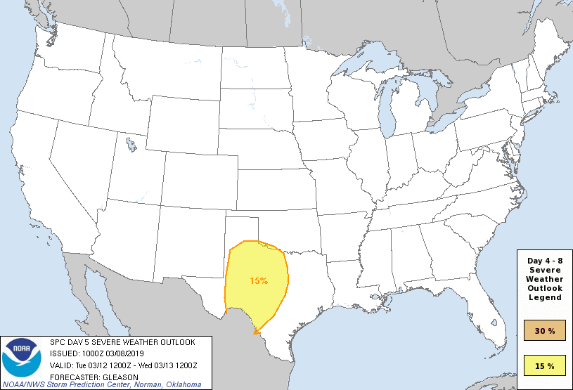 We will have to watch the potential for a more robust severe weather event with potential for a squall line to move through the state during the afternoon and evening hours. At this point, it is too early to pinpoint any potential impacts or exact timing or placement, so be sure to keep up to date with the latest forecasts. The rest of the week will feature clearing skies with highs in the upper 50s. 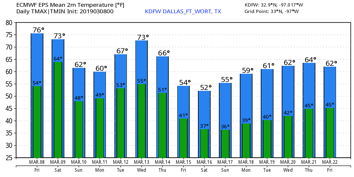 DAYLIGHT SAVING TIME BEGINS: DST begins this Sunday... Be sure to set your clocks forward an hour before you go to bed Saturday night. Sunset in DFW on Sunday will be at 7:32 PM CDT.
I will stay up to cover thunderstorms in North Texas early tomorrow morning if any warnings are issued! Be sure to stick with me and Jonathan William's Twitter Feed and Periscopes for live updates throughout the night. I will be traveling throughout spring break to Indianapolis to participate in the 2019 National Honor Band of America at the Music for All National Concert Festival. Updates, if any, will become very limited next week. Have a great weekend and enjoy next week! WARMER START: For the first time this week, we start the day below freezing. Temperatures are currently in the upper 40s to low 50s across the state, which means you can already tell how nice it will feel this afternoon. With a mix of sun and clouds in place, we will have afternoon highs in the low 70s. Another layer of clouds roll into the state tomorrow, but that will not stop us from reaching the low 70s in the afternoon. A few showers are possible Friday, but no severe weather is expected. SEVERE STORMS POSSIBLE SATURDAY: While a shower or two is possible during the late afternoon and evening hours, most of the severe weather will come during the morning hours on Saturday. A potent storm system with strong upper level winds will move southeast, and will congeal with the moisture and instability already in place. Therefore, severe storms are possible across a large swath of the south-central and eastern US; the SPC has defined the area of standard "slight risk" of severe storms over the Mississippi Delta region eastward into the Tennessee Valley. A "marginal risk" of severe storms exists from around North-Central Texas and generally for areas surrounding the slight risk. 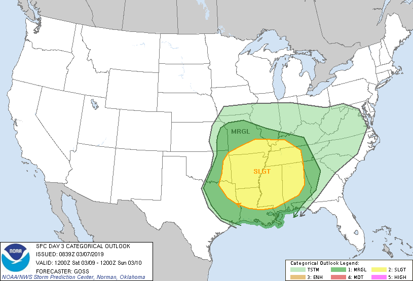 TIMING: The latest data suggests that the main window for strong to severe storms in North Texas will come in the morning from 5:00 AM through 1:00 AM CST Saturday. The rain and storms will shift to the east during the afternoon. THREATS: Thunderstorms will have the capability of producing hail and some damaging winds. A couple of brief tornadoes are possible during the morning hours, but the greatest threat for that will be confined to the greater severe weather risk during the afternoon. RAINFALL: Rain totals should generally stay below the quarter inch range, so no flash flooding issues are expected. CALL TO ACTION: Although this is not "one of those days" here in the Plains, this is the beginning stages of spring tornado season here in Texas, which means we can develop good safety habits now. Understand that this is very common for Texas, but also you must know to be ready for all of these threats this spring. Have a way of hearing warnings. NEVER RELY ON AN OUTDOOR SIREN... IF THIS IS YOUR ONLY WAY OF HEARING A WARNING, YOU WILL NOT UNDERSTAND WHAT IS GOING ON. It is imperative that you have a NOAA Weather Radio in your home, work, and school. Be sure wireless emergency alerts are enabled on your phone. Make sure you know your safe place and have the necessary supplies and gear for everyone in your home. Remember, if you are in a mobile home when a tornado warning is issued, YOU MUST LEAVE TO SEEK A SHELTER, OR A SITE BUILT STRUCTURE. NEXT WEEK: The global models now suggest a chance of showers with a mostly cloudy Monday for much of the state. Then, we turn wet with widespread rain and thunderstorms for much of the state on Tuesday before we dry out for the latter half of the week. See the Texas Weather Discussion Video for more details. 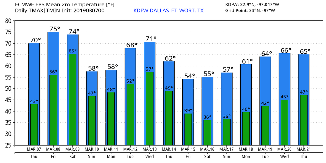 DAYLIGHT SAVING TIME BEGINS: DST begins on Sunday. A reminder to set your clocks an hour ahead before you go to bed Saturday. Sunset for DFW will come at 7:31 PM CDT.
Look for the next Texas Weather Discussion Video here by 7:00 AM tomorrow morning. Enjoy the Day! SUB-FREEZING START: Temperatures are in the 20s over the north-central part of the state this morning. We have lower 20s surrounding the metroplex. Burleson reports 22° at around 5:00am... Today will be very sunny with highs in the low to mid 50s. Clouds will increase tonight, as well as the warming trend. With ample sunshine we will be in the low 70s tomorrow and Friday. We will go ahead and mention the chance of a couple of showers on Friday as moisture levels rise as a result of a warm front lifting to the north. STRONG TO SEVERE STORMS POSSIBLE THIS WEEKEND: Another storm system will develop in the Plains this weekend, and will bring our first threat of severe weather for the season. Saturday will be very mild with highs in the low to mid 70s; thunderstorms are likely, but it won't rain all day. A deep surface low over northern Missouri will drag the dryline down into North Texas, causing a setup for severe thunderstorms late Saturday morning/Saturday afternoon. For now, it looks like the main window of the strongest storms for North Texas will come from 9:00 AM through 5:00 PM. The greatest threat of severe weather will most likely be confined to the Ark-La-Tex region, but the SPC has defined a broad zone of severe weather for Saturday for parts of the Central and Southern US. 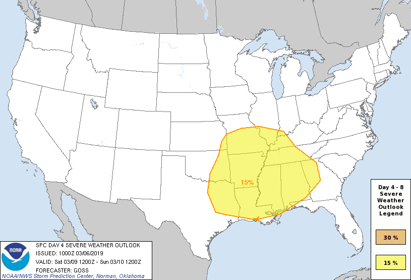 All modes of severe weather appear possible, including the potential for a few tornadoes. Rain amounts of generally 1/2 inch is expected, which will be less than sufficient for any flooding issues. More details will be ironed out as we get closer to the weekend. Sunday will be a bit cooler with clearing overnight... We will be in the mid 60s for most communities. NEXT WEEK: After a mostly dry workweek, rain chances return Monday and Tuesday with chances of widespread rain on Tuesday... See the Texas Weather Discussion Video for more details. 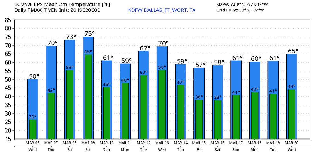 RADAR CHECK: We once again have freezing drizzle surrounding the metroplex. We don't have a winter weather advisory this morning, as the morning commute is not impacted. We can't rule out some patchy fog in some places either... Look for mostly cloudy skies again with highs in the lower 40s with upper 30s in some communities. THE WEEKEND: A cold front moves through early Saturday morning, causing a chance of scattered showers and storms by the evening, persisting through Sunday morning. Any precipitation this weekend will be light, and rain amounts of only a half of an inch is likely. At this point, I am not looking at a wintery weather event, as the extent of the dynamic cooling is suppressed by the flat ridge in the southern US. Just expect rain and thunderstorms at times this weekend. Afternoon highs will be in the upper 40s/low 50s Saturday, followed by mid to upper 30s Sunday. NEXT WEEK: An upper high in the High Plains will bring yet another surge of cold air by Monday. Despite some sun at times, we will start the day around the low 20s with temperatures in the low 30s by the afternoon. There's a chance that we will stay below freezing for much of the day. We slowly moderate through the week but morning lows will stay in the 20s for the early part of the week. 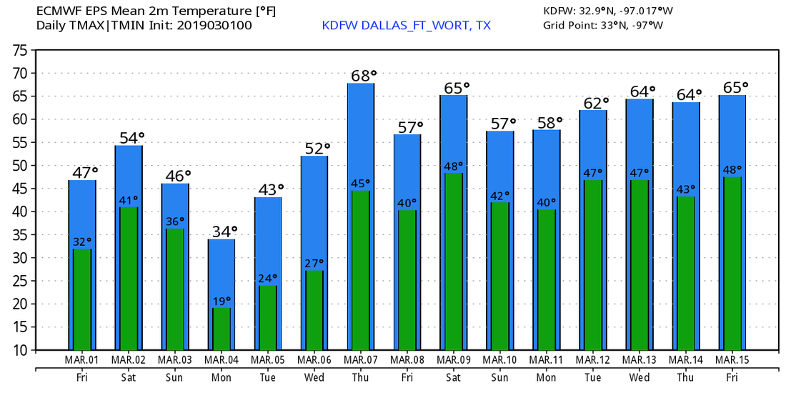 |
Archives
April 2024
Categories |
 RSS Feed