
|
RADAR CHECK: We once again have freezing drizzle surrounding the metroplex. We don't have a winter weather advisory this morning, as the morning commute is not impacted. We can't rule out some patchy fog in some places either... Look for mostly cloudy skies again with highs in the lower 40s with upper 30s in some communities. THE WEEKEND: A cold front moves through early Saturday morning, causing a chance of scattered showers and storms by the evening, persisting through Sunday morning. Any precipitation this weekend will be light, and rain amounts of only a half of an inch is likely. At this point, I am not looking at a wintery weather event, as the extent of the dynamic cooling is suppressed by the flat ridge in the southern US. Just expect rain and thunderstorms at times this weekend. Afternoon highs will be in the upper 40s/low 50s Saturday, followed by mid to upper 30s Sunday. NEXT WEEK: An upper high in the High Plains will bring yet another surge of cold air by Monday. Despite some sun at times, we will start the day around the low 20s with temperatures in the low 30s by the afternoon. There's a chance that we will stay below freezing for much of the day. We slowly moderate through the week but morning lows will stay in the 20s for the early part of the week. 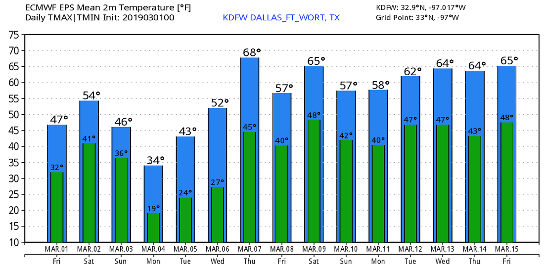 |
Archives
March 2023
Categories |
 RSS Feed
