
|
WARMER START: For the first time this week, we start the day below freezing. Temperatures are currently in the upper 40s to low 50s across the state, which means you can already tell how nice it will feel this afternoon. With a mix of sun and clouds in place, we will have afternoon highs in the low 70s. Another layer of clouds roll into the state tomorrow, but that will not stop us from reaching the low 70s in the afternoon. A few showers are possible Friday, but no severe weather is expected. SEVERE STORMS POSSIBLE SATURDAY: While a shower or two is possible during the late afternoon and evening hours, most of the severe weather will come during the morning hours on Saturday. A potent storm system with strong upper level winds will move southeast, and will congeal with the moisture and instability already in place. Therefore, severe storms are possible across a large swath of the south-central and eastern US; the SPC has defined the area of standard "slight risk" of severe storms over the Mississippi Delta region eastward into the Tennessee Valley. A "marginal risk" of severe storms exists from around North-Central Texas and generally for areas surrounding the slight risk. 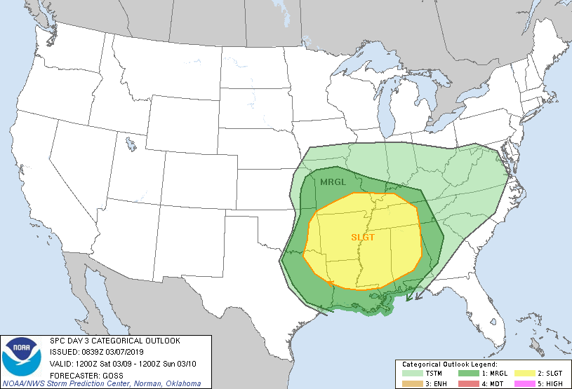 TIMING: The latest data suggests that the main window for strong to severe storms in North Texas will come in the morning from 5:00 AM through 1:00 AM CST Saturday. The rain and storms will shift to the east during the afternoon. THREATS: Thunderstorms will have the capability of producing hail and some damaging winds. A couple of brief tornadoes are possible during the morning hours, but the greatest threat for that will be confined to the greater severe weather risk during the afternoon. RAINFALL: Rain totals should generally stay below the quarter inch range, so no flash flooding issues are expected. CALL TO ACTION: Although this is not "one of those days" here in the Plains, this is the beginning stages of spring tornado season here in Texas, which means we can develop good safety habits now. Understand that this is very common for Texas, but also you must know to be ready for all of these threats this spring. Have a way of hearing warnings. NEVER RELY ON AN OUTDOOR SIREN... IF THIS IS YOUR ONLY WAY OF HEARING A WARNING, YOU WILL NOT UNDERSTAND WHAT IS GOING ON. It is imperative that you have a NOAA Weather Radio in your home, work, and school. Be sure wireless emergency alerts are enabled on your phone. Make sure you know your safe place and have the necessary supplies and gear for everyone in your home. Remember, if you are in a mobile home when a tornado warning is issued, YOU MUST LEAVE TO SEEK A SHELTER, OR A SITE BUILT STRUCTURE. NEXT WEEK: The global models now suggest a chance of showers with a mostly cloudy Monday for much of the state. Then, we turn wet with widespread rain and thunderstorms for much of the state on Tuesday before we dry out for the latter half of the week. See the Texas Weather Discussion Video for more details.  DAYLIGHT SAVING TIME BEGINS: DST begins on Sunday. A reminder to set your clocks an hour ahead before you go to bed Saturday. Sunset for DFW will come at 7:31 PM CDT.
Look for the next Texas Weather Discussion Video here by 7:00 AM tomorrow morning. Enjoy the Day! |
Archives
March 2023
Categories |
 RSS Feed
