
|
AVERAGE MORNING - It's a pretty decent morning here in the Lone Star State; temperatures are in the mid to upper 70s across the region this morning, pretty average for the last day of July. We do note that there will be some subsidence from the cold front and rain yesterday, and we will forecast a mix of sun and clouds today as a result. Afternoon highs will be close to 90 degrees, about six to seven degrees below the average temperature of 97 for late July. An isolated storm or two can't be ruled out during the afternoon. WEDNESDAY THROUGH FRIDAY - Look for much of the same weather for the next few days; mostly sunny, hot, and somewhat humid with highs in the mid 90s for the midweek. We start to heat back up next week. THE WEEKEND - Not much change. We continue to roll with a persistent forecast for the rest of the week and the weekend with no change in our current summertime weather pattern. We expect afternoon highs to be mostly in the upper 90s with mostly sunny skies. NEXT WEEK - We go back to triple digit heat as soon as next week hits with mostly sunny skies. Our current weather pattern stays mostly the same through most of the week. The GFS indicates much of the Deep South will stay dry for this time period as well. Expect highs in the upper 90s/low 100s with lows in the mid 70s. See the Texas Weather Discussion Video for more details. 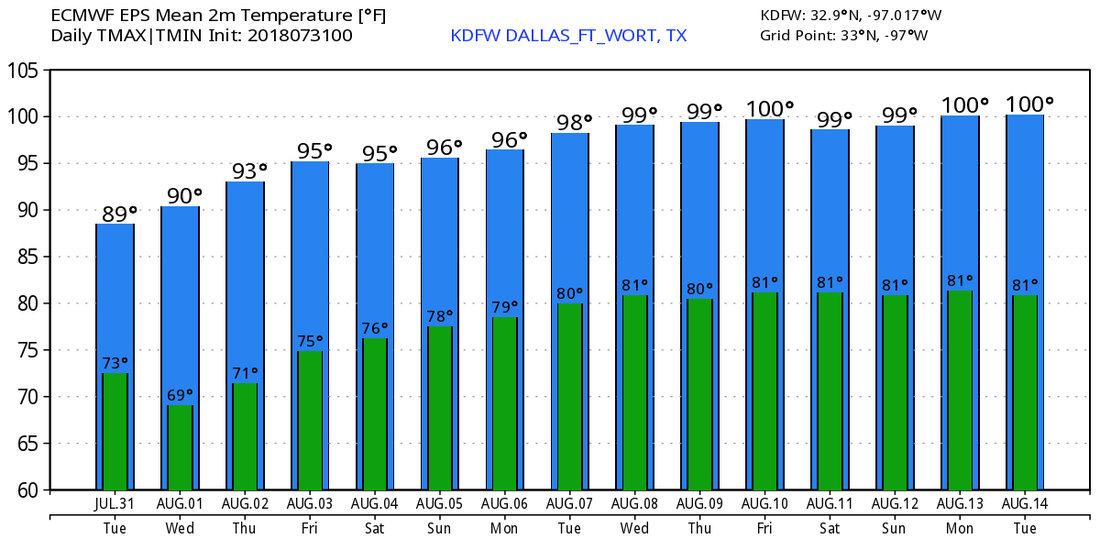 TROPIX - All remains quiet in the Atlantic Basin, and no new tropical cyclone development is expected for the next five days.
RADAR CHECK - A complex of showers and thunderstorms are continuing to move southeast along a cold front this morning. It is now located in Southern Oklahoma, spreading into parts of North Texas... 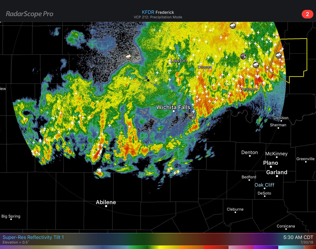 They will continue to move to the southeast this morning, arriving in the DFW metro between 7 to 10 AM. The best chance of one spot getting wet this morning will be in the 50/60 percent range as they drift to the southeast. Some of the stronger storms could produce wet microbursts and gusty winds as well, though some small hail can't be ruled out this afternoon. The best time frame for scattered showers and thunderstorms today will be from 7AM to 2PM. It will be mostly cloudy today with afternoon highs closer to 90 degrees for the next few days, a nice break from the typical summer time heat here in North Texas. MIDWEEK - The front dissipates in South Texas later this week, but we will still be in the low to mid 90s as a result of the front passing through today. The sky will clear out and sunshine will be in full force by Wednesday and Thursday. Overnight lows will be in the upper 70s. FRIDAY AND THE WEEKEND - Not much change to the previous weather for our midweek. Expect much of the same thing for the rest of the weekend; mostly sunny and hot with afternoon highs in the mid to upper 90s; right at seasonal averages for the beginning of August. NEXT WEEK - We go back to the routine summer time weather here in North Texas; hot, humid, mostly sunny with afternoon highs in the upper 90s to low 100s, which sounds pretty typical for early August. The GFS indicates another trough developing over the Midwest, bringing down another cold front across the Deep South. More than likely that front will not extend westward and we will continue to stay sunny and hot for the latter half of next week, but we will continue to watch trends. See the Texas Weather Discussion Video for more details.  TROPIX - The Atlantic Basin continues to remain very quiet, and no new tropical cyclone development is expected within this week. Keep in mind that the climatological peak of hurricane season is usually in mid September.
ANOTHER QUIET MORNING - The only shower activity occurring in North Texas is the few showers near Sulphur Springs. Temperatures are in the low 80s this morning with a clear sky. Expect afternoon highs to be at 100 degrees with sunshine in full force. A very weak surface front moves through later today which could set off a few isolated showers and thunderstorms during the afternoon, but the chance of one spot getting wet is only in the 10-20 percent range, so don't have high hopes of seeing rain today. THE WEEKEND - Some showers will still be lingering during the weekend from the weak surface front on Friday, but will be widely spaced with no dynamic support and limited moisture. Otherwise, expect afternoon highs around 100 with more sun than clouds on both days. NEXT WEEK - A strong cold front will come through early Monday morning, which will cause cooler temperatures for the next several days, as well as a spike in moisture levels to introduce the chance of scattered to numerous showers and thunderstorms, mostly Monday morning. Some showers will carry on into Tuesday, and temperatures will be below average with highs mostly close to 90. See the Texas Weather Discussion Video for more details.  TROPIX- The Atlantic Basin continues to remain very quiet, and tropical cyclone formation is not expected through the weekend.
Temperatures are in the upper 70s/low 80s this morning in the Lone Star State. We project a high close to 100 degrees with mostly sunny skies and a few clouds. The radar is clear this morning.
FRIDAY AND THE WEEKEND - A weak cold front comes through the region on Friday, but adequate moisture will not be there to support scattered showers and thunderstorms, but we will still mention an isolated chance in the forecast where moisture is sufficent. The chance of one spot seeing rain tomorrow is only in the 5 to 10 percent range, and afternoon highs will be in the upper 90s, very close to 100 degrees. The rest of the weekend looks dry with more sun than clouds with afternoon highs pretty much on the triple digit mark. NEXT WEEK - A pattern change comes Monday morning with a strong cold front coming through during the pre-dawn hours which will bring scattered rain chances with much lower temperatures. The best chance of one spot getting wet on Monday is about 50/50. Afternoon highs will be in the low to mid 90s for the rest of the week. See the Texas Weather Discussion Video for more details. ANOTHER TYPICAL SUMMER DAY - We are forecasting highs closer to 100 degrees again today as a upper high continues to cover the southwestern U.S. We will continue to see more sun than clouds as we stay dry for much of the day. REST OF THE WEEK - Not much change. Expect much of the same weather for the next few days; hot, breezy, mostly sunny with a few clouds with highs in the triple-digits, closer to 100 degrees. THE WEEKEND -Expect another dry weekend ahead with much of the same weather throughout. Afternoon highs will be mostly at the 100 degree mark for most communities. Overnight lows will be in the upper 70s. NEXT WEEK - An upper-trough will cover parts of the midwestern states which will allow a surface front to move south through Texas early Monday morning. This will open the door for cooler temperatures, and maybe a chance of scattered showers and thunderstorms on Monday. The best chance of any one spot getting wet will be in the 40-50 percent range early Monday morning into the afternoon. Highs will be in the low to mid 90s for the rest of the week, a 20+ degree difference from this weekend. The Climate Prediction Center continues to forecast below average temperatures for North Texas during the July 30 - August 3 forecast period. See the Texas Weather Discussion Video for more details. 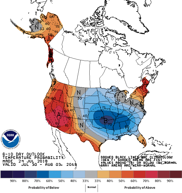 TROPIX - Tropical Cyclone Formation is not expected for the rest of this week through the weekend.
Temperatures continue to be in the low to mid 80s this afternoon under a clear sky. The radar is actually clear this morning with no isolated drizzle about. Today will be another hot day with afternoon highs in the upper 90s. If DFW can stay below 100 today, this would break our streak of consistent 100 degree heat. REST OF THE WEEK THROUGH THE WEEKEND - We fall into a more tolerable kind of hot, meaning, it won't be as hot as this weekend or late last week. Highs will still be closer to 100 degrees with mostly sunny skies. The overall pattern will not change much this week. Lows will be in the upper 70s/low 80s. NEXT WEEK - A trough sets up in the lower Midwest near the Corn Belt that will help in pulling a cold front down Monday morning. That would mean chance of mainly morning showers and thunderstorms with cooler temperatures during the afternoon. The most widespread activity looks to occur during the morning with afternoon highs in the mid 90s afterwards; that's about 20 degrees cooler than the highs last week. It's also worth noting that the Climate Prediction Center suggests on their new 6-10 day temperature outlook that we have a fair chance of seeing slightly below average temperatures. That doesn't mean it will be cool, just slightly more tolerable. See the Texas Weather Discussion Video for more details.  TROPICS - All is quiet in the Atlantic Basin, and no new tropical cyclones are expected through the weekend.
Temperatures an hour before daybreak are already in the mid to upper 80s this morning. That's a clear indication of how hot it is going to be later in the day. But thankfully, a very weak cold front will come through later this morning which will trim our afternoon high back a couple of degrees. Highs will be in the mid to upper 100s with mostly sunny skies again. It is worth noting that the Excessive Heat Warning remains in effect for areas to the south of Interstate 20 until 7p. Subsequently, a Heat Advisory remains in effect for the rest of the North Texas area.  MIDWEEK THROUGH FRIDAY - Not much change. Although we do start to cool down a few degrees as we progress through the week with afternoon highs closer to 100 degrees, a more tolerable kind of hot. THE WEEKEND - Not much change in the current forecast. We will continue to forecast hot, humid, and breezy conditions with afternoon highs in the upper 90s/low 100s, closer to seasonal averages. NEXT WEEK - On Monday morning, a trough will push the upper high to the west, which will allow for a cold front to come through by Monday. This has been indicated by global models for quite some time, which also means that we will have a decent chance of showers and thunderstorms on Monday with highs in the mid 90s for the rest of the week. That would be about 20 degrees cooler than in recent days if this forecast solution were to verify. Expect mostly sunny conditions for the rest of the week. See the Texas Weather Discussion Video for more details. TROPICS - All is quiet in the Atlantic Basin, and tropical cyclone formation is not expected within the next week.
Today was another record setting day, with an official high of 109° around 4pm. But this record high trend is going away, as a cold front is likely to move through the area tomorrow. Highs will still reach 100° or so, but not nearly as miserable! A few hit or miss storms could develop behind the front, but subsidence from the lingering high pressure should keep storms at a minimum. However, IF any storms even develop, they could produce damaging wind gusts and very heavy rainfall. Only 10-20% of us will see any rainfall. Typical... Heading through the rest of the week, we will remain dry with highs in the upper 90s to lower 100s. But, it won’t be nearly as miserable as the past few days, just a more “tolerable” hot type of conditions. Stay hydrated! We are starting to raise thunderstorm chances for Sunday into next Monday as a cold front is expected to encroach the region. This will enhance storm chances and may give us our best chance of rain we’ve had in a while!  As we are still in the summertime, it’s getting to that point of year where we begin to think about the upcoming fall and winter as we are getting closer and closer to the start of meteorological fall on September 1st, which is only 40 days from now! Also, Christmas is only 156 days away! ;) This winter looks to be a polar opposite of some of our past winters as we may have a colder pattern. (Haha, get it??) The type of pattern we will (likely) have this winter is a moderate El Niño Modoki. This tends to bring the storm track south and colder air much farther south. 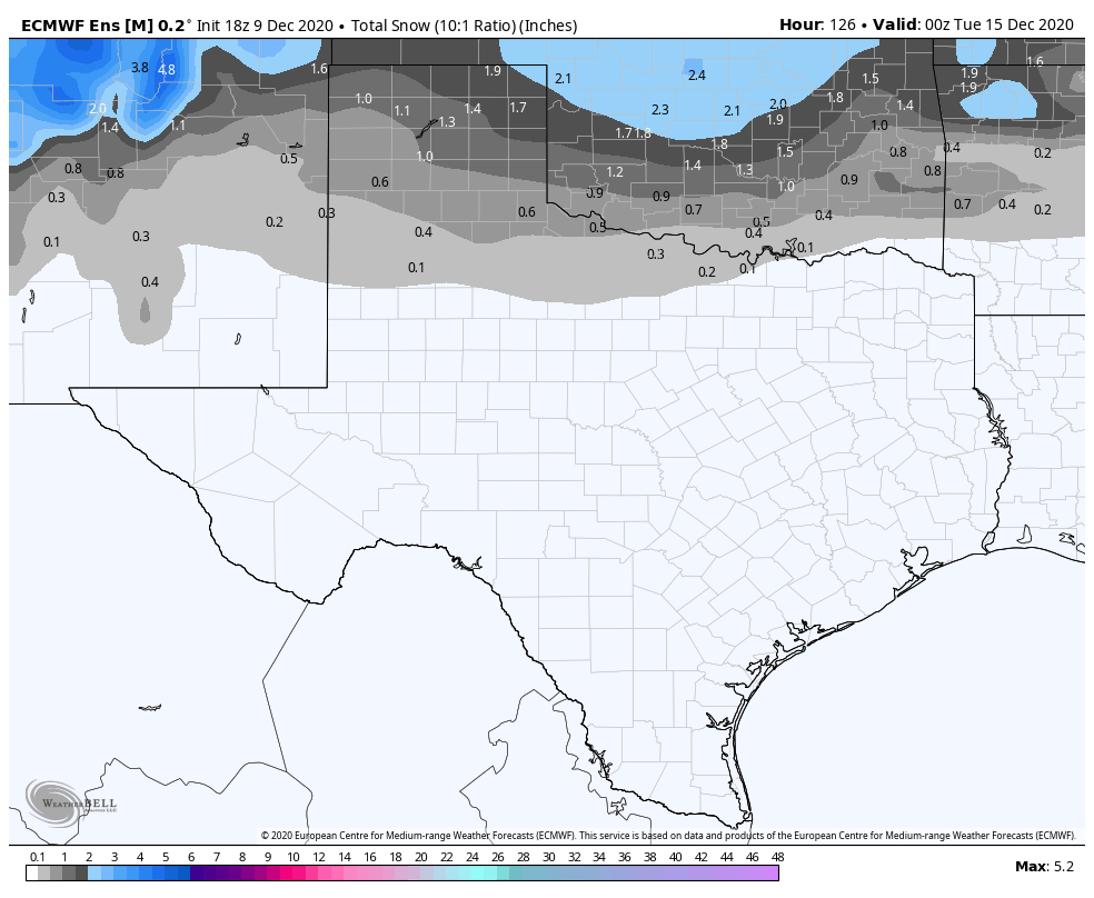 This pattern tends to bring much colder air to the state of Texas. 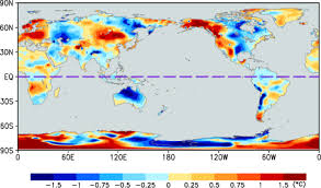 We will continue to keep an eye on this, as we are LONG overdue on a major winter storm. I am NOT going to guarantee anything, but the odds of colder and wetter weather are greater this year than the past few years. (2015-16, 2016-17, 2017-18 Winters) These last few years where we have lacked snow and cold air have been La Niña winters and have not been in the favor of winter storm lovers. The La Niña has kept the storm track to the north and the cold air locked in the NE CONUS. Here’s a graphic explaining the pattern differences between La Niña and El Niño. 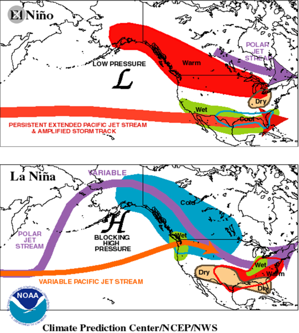 The exact definition of an El Niño Modoki is El Niño Modoki is a coupled ocean-atmosphere phenomenon in the trop. Pacific. It is different from another coupled phenomenon in the Pacific, a typical El Niño. El Niño is characterized by strong anomalous warming in the eastern equatorial Pacific, as this will apply to this upcoming winter. (should the pattern favor a Modoki)
We will watch this, and we hope you have a fantastic week! The Texas Weather Discussion Video will he uploaded tomorrow! Jonathan Williams IT'S HOT - Temperatures in most places are already in the mid 80s this morning, meaning we did not fall out of the 80s overnight. That's when you know it's going to be a long, hot day. Expect much of the same weather today with afternoon highs in the upper 100s. The projected high today is around 109-110, beating out the previous record of 105 set in 2012. Excessive Heat Warning is still in effect through Monday evening. THE WEEKEND - We will see more record breaking temperatures this weekend with project afternoon highs in the low 110s on Saturday and the upper 100s/low 110s on Sunday as well. The current record for July 20 and the 21 is 107 and 106, set back in 2012 and 1974, respectively. NEXT WEEK - Not much extreme change will go on with our extreme weather. Though a trough in the Great Lakes will push a cold front south by the latter half of the week which will cool us down to the upper 90s by late next week followed by a small chance of isolated showers and thunderstorms. Most places stay dry. 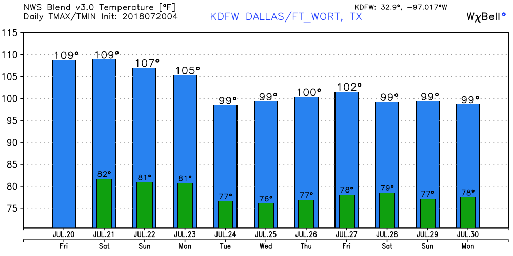 Thought these past few days were really hot? It's only going to get hotter from here. That is why the NWS has issued an Excessive Heat Warning for much of the North Texas area including the DFW metro. The warning will go into effect this afternoon through Friday evening. This is the first time an Excessive Heat Warning has been issued for our area since August of 2011. Typically, prolonged heat waves like occurs only once every few years. We will not fall below the 80s for the next few days, and afternoon highs will be in the upper 100s today and tomorrow. The forecast high for Friday is 108°, which will set the record temperature for that day, beating out the previous record of 105° set in 2012. It is imperative that you are practicing heat safety anywhere you go.  THE WEEKEND - Not much change. Expect mostly sunny skies with dangerously hot and humid conditions with afternoon highs in the mid to upper 100s. Some communities could surpass 110°. Make sure you are taking frequent breaks if you must do anything outside during the weekend. NEXT WEEK - The early part of next week looks the same; hot, humid with mostly sunny skies and highs in the low to mid 100s. By the latter half of the week, a trough will develop in the Great Lakes and expand and move southward. This will allow a cold front to develop and push to the south which will slightly cool temperatures down followed by a chance of very isolated showers and thunderstorms. It won't cool down too much, as highs by late next week will be in the upper 90s, but it won't be brutally hot. 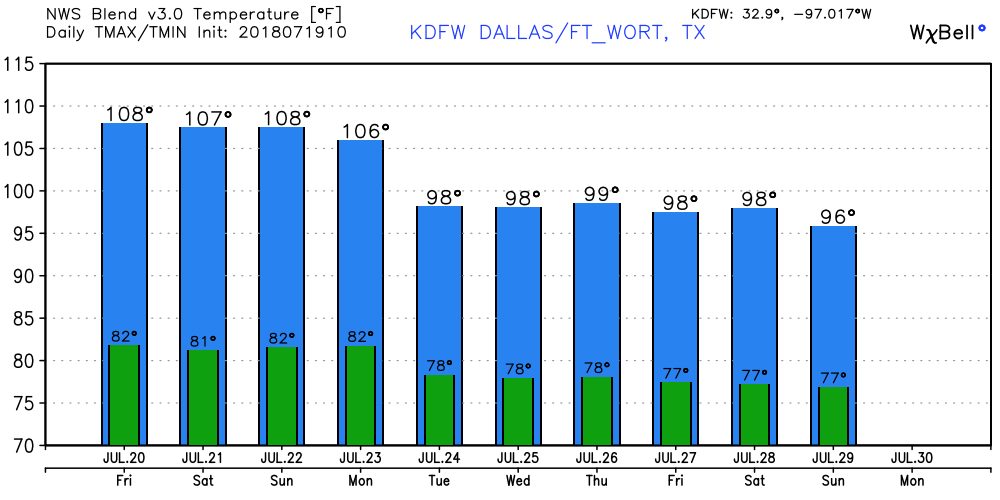 TROPIX - The Atlantic Basin remains quiet, with no new tropical cyclone development expected within the next week.
DANGEROUS HEAT CONTINUES - The NWS has issued an Excessive Heat Watch from Thursday afternoon to Friday evening. Temperatures will be in the mid 100s on both days with lows sticking in the 80s. Make sure you are doing everything you can to stay away from heat illnesses. Drink plenty of water, take frequent breaks from outside activity, and make sure you are close to an air-conditioned building. Furthermore, be sure to check up on the elderly frequently, as they are more prone to heat-related illnesses.  Not much has changed with the current forecast for the week. Please refer to yesterday's blog post for more details. FOR THE REST OF THE WEEK - Not much change overall in the synoptic scale. In fact, we will only get hotter as the head towards the weekend. Highs will be in the low 100s on Wednesday, heating up to the mid 100s by Friday. That's why the Heat Advisory is in effect for our area. Not much change for the weekend either. Expect much of the same weather again with afternoon highs in the low 100s with bright and sunny skies. NEXT WEEK - It's looking increasingly likely that most of next week stays dry as well with pretty much the same weather; hot, sunny, and breezy with highs in the triple digits as we start to close out July. 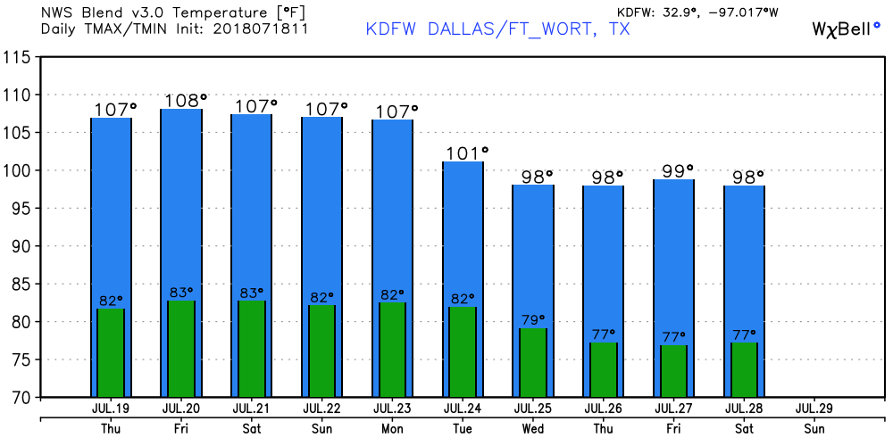 TROPIX - All is quiet in the Atlantic Basin, and no new tropical cyclones are expected through the next week.
I'm really starting to feel like a broken record saying the same thing pretty much everyday. Not much change to our current weather pattern as of now. We are still in the upper high pressure zone since the last few days with very little change. Highs will continue to be in the low 100s this afternoon. It is worth noting that a Heat Advisory will go into effect from noon until 8PM Wednesday for the DFW metro and points to the south due to possible high temperatures in the 103-105 range this afternoon and for the next few days.  FOR THE REST OF THE WEEK - Not much change overall in the synoptic scale. In fact, we will only get hotter as the head towards the weekend. Highs will be in the low 100s on Wednesday, heating up to the mid 100s by Friday. That's why the Heat Advisory is in effect for our area. Not much change for the weekend either. Expect much of the same weather again with afternoon highs in the low 100s with bright and sunny skies. NEXT WEEK - It's looking increasingly likely that most of next week stays dry as well with pretty much the same weather; hot, sunny, and breezy with highs in the triple digits as we start to close out July. See the Texas Weather Discussion Video for more details. 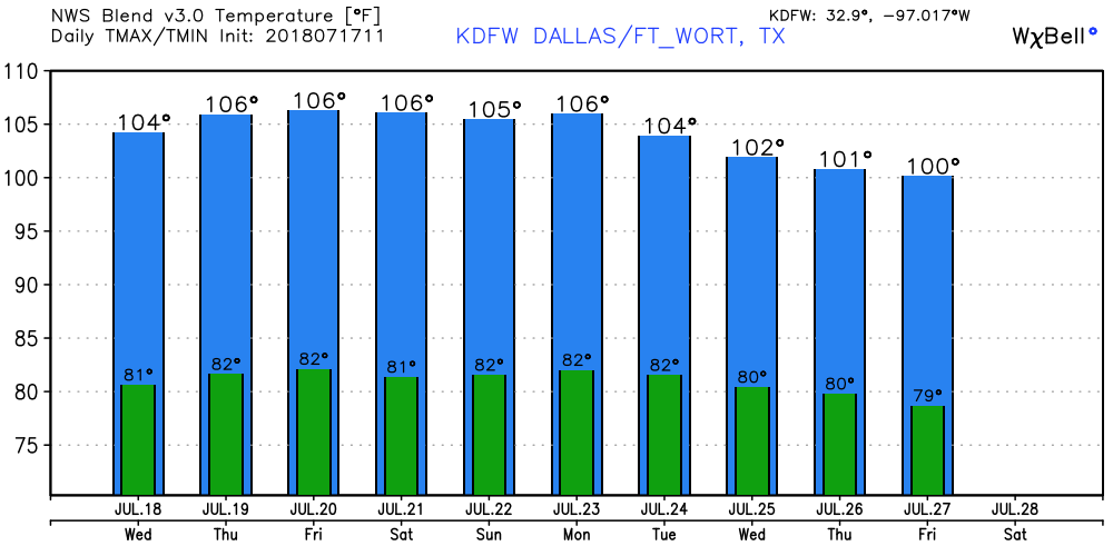 We have officially entered the time of the year where the overall weather pattern does not change much. You can say "today will be mostly sunny and very hot with afternoon highs in the low to mid 100s" and get the forecast right 98% of the time. This will be the case for the next week as an area of high pressure builds over the rockies and spreads into Texas over the course of this week. Highs will be in the low 100s this afternoon. REST OF THE WEEK THROUGH THE WEEKEND - Not much change at all. In fact, we get even hotter by this weekend. We continue to forecast mostly sunny skies each day with afternoon highs in the low to mid 100s. There is a possibility Friday and/or Saturday's high could be exceed 104 or 105 by the afternoon. The record high for Dallas on July 20 is 104, set back in 2000. Anything above 104 would likely be a record high at this point. NEXT WEEK - Expect much of the same weather this next week with mostly sunny skies under hot, humid conditions. Afternoon highs will continue to stay in the low to mid 100s. No sign of any relief from the triple-digit heat for at least the next ten days. See the Texas Weather Discussion Video for more details.  TROPICS - Beryl became a Remnant Low yesterday over the North Atlantic and dissipated this morning. The rest of the Atlantic Basin, including the Gulf of Mexico, remains very quiet. Tropical cyclone formation is not expected this week.
There is very little change in our upper air pattern with a broad ridge encompassing much of the Continental U.S. As a result, expect more of the same thing today with mostly sunny skies under hot and humid conditions with highs in the upper 90s/low 100s. Precipitable water values remain above average, so a few isolated showers and thunderstorms could develop during the afternoon and evening hours for our western counties. Most places stay dry today. 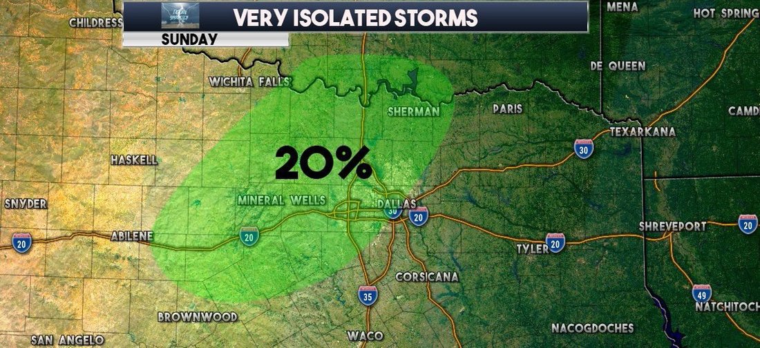 As noted in previous blog posts, the overall pattern for Texas will change as the upper level ridge moves westwards and parks itself in the Rockies by midweek. Not much changes here in North Texas. As indicated by the Precipitable Water Values, we pretty much stay in the same loop of hot and humid weather through the week. Highs will stay in the low 100s/but there is enough indication that highs could reach 105 by Wednesday. Not much change in our weather pattern towards the latter half of the week. We stay in the same loop with mostly sunny skies with hot and humid conditions with highs in the low 100s. This will spark drought conditions statewide and raise heat safety concerns. Be sure to look and see if your county is under a burn ban due to drought conditions and make sure you are practicing heat safety wherever you go. Looking out into next week, the GFS is convinced that we do not see any relief from the excessive heat during the week. The upper air pattern stays the same for much of the U.S. with very little change. That means we would continue to see afternoon highs in the upper 90s to low 100s during the peak of the day. The Atlantic Basin remains quiet with the exception of Subtropical Storm Beryl, which regenerated yesterday and is expected to weaken to a tropical depression by early Monday morning. 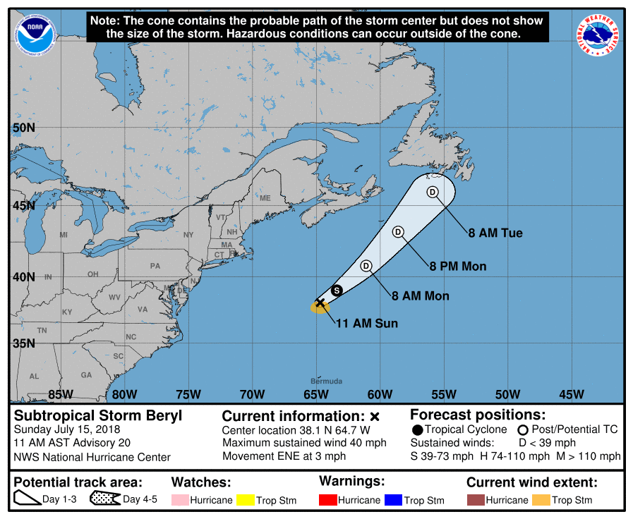 MORNING SUN, SOME PM STORMS - Today will be the last day of afternoon showers and thunderstorms for a while. We do start out nice and sunny this morning, but we will once again see the chance of isolated afternoon showers and thunderstorms during the afternoon and evening hours. Any thunderstorm that develops will most likely come between 12:00 and 8:00 PM, and the chance of one spot getting wet will be in the 10/20 percent range today. Elsewhere, expect mostly sunny skies with afternoon highs in the mid to upper 90s. THE WEEKEND - We go back to our regular summer time routine here in North Texas; sunny, hot, humid with highs in the upper 90s/low 100s during the afternoon. Most places stay dry. NEXT WEEK - Not much change for most of the week. In fact, we warm up a few degrees by midweek with highs near 102-103 by Wednesday afternoon. Then, an upper trough forms over the eastern half of the nation, which could cool us down a few degrees, but we won't notice any real difference. Dry air continue to filter in for the rest of the week... See the Texas Weather Discussion Video for more details. 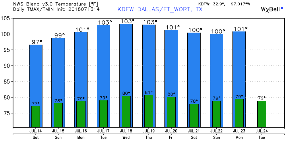 TROPIX - The Remnants of Beryl is several hundred miles to the east of the Carolinas, and continues to remain very disorganized. So disorganized that the NHC has lowered the chance of regeneration to 20 percent. One way or another, it will move northeast following Chris, posing no threat to the U.S. at all. The rest of the Atlantic Basin remains very quiet with nothing expected in the Gulf of Mexico for a long time. 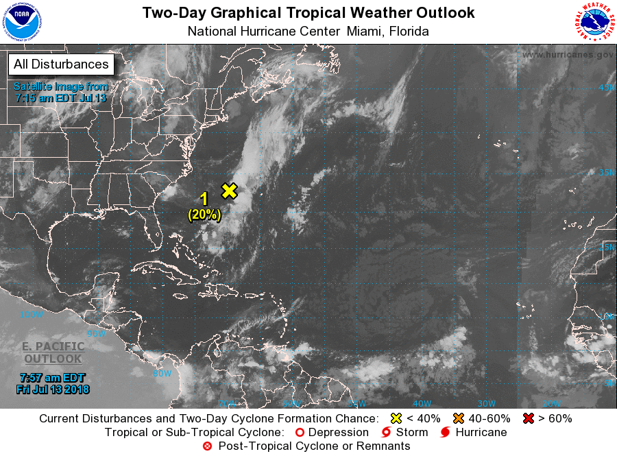 MORE SHOWER/STORMS TODAY - A shortwave trough is moving to the west from the east, which means we will see an enhancement of showers and thunderstorms this afternoon during the peak of the daytime heating process. Most of the showers will not develop until after 12 PM, and the best chance of any one spot getting wet is in the 40/50 percent range for today, falling to 20/30 percent tomorrow. However, we can't rule out the potential for any overnight/early morning showers and storms tonight, given the type of atmosphere we are in. Afternoon highs will be in the mid 90s today and tomorrow. THE WEEKEND - We clear out for the weekend, going back to our routine summer weather pattern for mostly sunny skies in humid conditions with most highs in the triple digits. NEXT WEEK - Not much change in the weather pattern for next week. We continue to forecast mostly sunny skies in a humid airmass with highs in the triple digits for most spots. The GFS indicates the idea of a trough in the Midwest near the Ohio Valley, and a 594 millibar heat ridge extending into Texas from the Western U.S. The GFS wants to bring a cold front with scattered showers and thunderstorms in the mix, but is unlikely because fronts usually don't make it this down south this time of the year. See the Texas Weather Discussion Video for more details.  TROPIX - Formally Tropical Storm Chris has become Post Tropical Cyclone in the Northern Atlantic this morning. It will continue to move to the northeast, away from the U.S. The Ghost of Beryl is just to the north of the Bahamas. The NHC still has a 50/50 chance of regeneration. One way or another, it will follow the same path as Chris, moving to the northeast, away from the U.S. The deep Atlantic Basin remains quiet, with no tropical development expected in the Gulf of Mexico anytime soon. 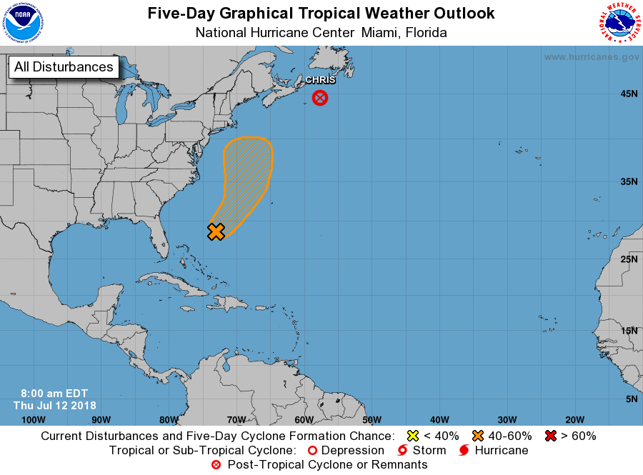 ABNORMAL MOISTURE LEVELS CONTINUE - For the past few days, robust moisture levels have been in place over much of North and Central Texas as well as East Texas, and most of the showers and thunderstorms over the state have in those regions, respectively. We will continue to forecast scattered afternoon showers and thunderstorms with daytime heating region-wide later today. The best chance of any one spot getting wet is in the 30/40 percent range, and the high this afternoon will be in the mid 90s. FRIDAY THROUGH THE WEEKEND - A surface front will move southward from the north, but should dissipate before reaching North Texas. With moisture levels starting to come down, we will roll with a persistent forecast for Friday and through the weekend with mostly sunny skies and humid days with highs in the upper 90s to low 100s. An isolated shower or thunderstorm in a place or two is not ruled out. NEXT WEEK - Not much change. As we roll with a persistent forecast, our routine summer time pattern continues with highs in the upper 90s to low 100s. See the Texas Weather Discussion Video for more details.  CHRIS FINALLY MOVING - Hurricane Chris peaked in intensity earlier this morning. It will gradually weaken later this week through the weekend as it moves over cooler waters. By Friday, it should become post-tropical as it moves away from the Northern Atlantic. 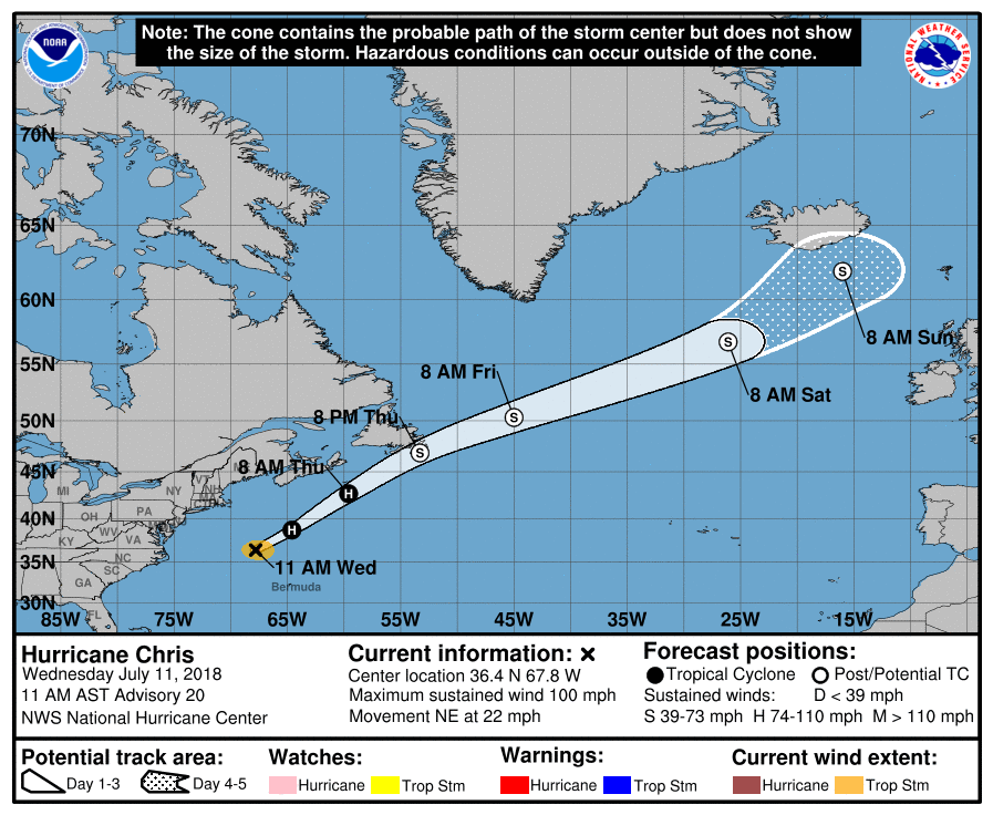 THE GHOST OF BERYL - The remnants of Beryl are over the Bahamas at this point. The NHC rolls with a 50/50 chance of redevelopment within the next five days. One way or another, it should move to the northeast, following Chris with no threat to land.
FAIRLY QUIET MORNING - Most communities are quiet this morning with temperatures in the low to mid 80s today, but a couple of showers and thunderstorms are already starting to develop near Parker and Palo Pinto counties. We will see better coverage of scattered showers and thunderstorms later today with a tropical airmass still in place. As noted in the Precipitable Water values, the better coverage of showers and thunderstorms will be from a line near Henrietta to Brownwood and points to the east. Today's high will be in the low to mid 90s for most communities. MIDWEEK - Widely scattered showers and thunderstorms will remain possible tomorrow and Thursday, but the better coverage of scattered nature will be Thursday as moisture levels increase for the day. The best chance of any one spot getting wet will be in the 50/50 range on Thursday with highs in the low to mid 90s. The best coverage of the rain will come from 12:00 to 9:00 PM each day. THE WEEKEND - We go back to fairly routine summer time weather sunshine in full force. Highs will warm back up in the upper 90s to the low 100s. NEXT WEEK - Consistent summer time weather will be in the forecast for much of next week with abundant sunshine with highs in the upper 90s to the low 100s.  TROPICS - Chris is a high-end tropical storm in the Atlantic with pressure down to 996 millibars with maximum sustained winds at 70 mph. It is expected to become a hurricane later today. The storm has already began movement to the northeast at 9 mph. It will continue to move to the northeast through the course of this week, becoming post-tropical cyclone by this weekend. It will have indirect impacts to the Eastern U.S. Coast, such as rough surf and rip currents. 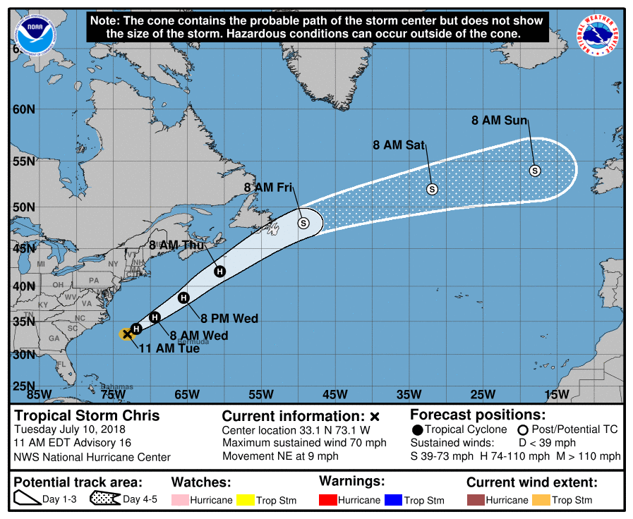 BERYL - The remnants of Beryl is currently located near Hispaniola this morning. The National Hurricane Center gives it a 50/50 chance of it regenerating into a tropical cyclone within the next 5 days. One way or another, it will turn to the northeast, away from the US.
DRIER AIR OVER TEXAS PANHANDLE - Drier air covers some of the counties in the Texas Panhandles at 10:00 AM this morning. A weather station in Dumas recorded a temperature of 79°, which is abnormal for this time in July. Deep moisture covers much of North and Central Texas this morning, which is where we expect the greatest coverage of scattered showers and thunderstorms today and tomorrow.  Highs this afternoon will be in the mid to upper 90s in most spots. MIDWEEK - As we get towards the latter half of the week, the coverage of showers and thunderstorms during the afternoon and evening hours will lessen as drier air starts to filter in from the north. By that time, the best chance of any one spot getting wet will be in the 20 percent range. We will still have a mix of sun and clouds with afternoon highs in the mid to upper 90s. THE WEEKEND - We start to get back with routine summer-time weather for Texas; mostly sunny and humid with an isolated afternoon storm or two. Highs will be in the upper 90s to low 100s. NEXT WEEK - We start to get into the "dog days" of summer with mostly sunny skies, hot and humid conditions with highs in the upper 90s and low 100s during the afternoon. 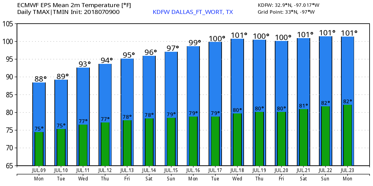 TROPICS - Tropical Storm Chris is stationary off of the Carolina coast with maximum sustained winds of 60 mph. It is expected to become a hurricane tomorrow, but won't today because of sitting over the same water for a long time with cooling SSTs and drier air starting to filter in. But that should filter out as soon as it starts moving. 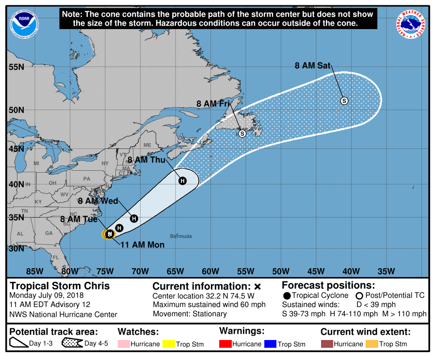 AS FOR BERYL - Tropical Storm Beryl dissipated yesterday. But, it is not completely off the board yet. It still has some chance of regenerating into a tropical cyclone near the Bahamas in the next 5-7 days. It will make a turn to the northeast and kick off to sea.
No tropical cyclones are expected to impact the Gulf of Mexico or southern U.S. for the next 5-7 days. See the Texas Weather Discussion Video for more details. COULD BE WET? - We are starting the day off with sunshine in full force this morning, but west-moving showers and thunderstorms are possible by the afternoon hours into tonight as a weak impulse in Central Texas continues to affect our weather pattern. The chance of any one spot getting wet is in the 30/40 percent bracket. Keep in mind that it will be nearly impossible to predict exact start/stop times of the thunderstorms due to the scattered, random nature of them, but the main window of the most coverage will be from 12:00 to 8:00 PM. Highs this afternoon will be in the mid to upper 90s. A front approaches from the north and stalls near the North Texas/Oklahoma border on Saturday, which will keep our weather unsettled over the weekend. We continue to forecast a mix of sun and clouds afternoon showers and thunderstorms on both days. Highs will be in the mid 90s through the weekend. NEXT WEEK - The front slowly fizzles out early next week, but enough moisture and instability will stay in place for our weather pattern to be unsettled for a good chunk of next week. A mix of sun and clouds with showers and thunderstorms are possible each day with highs in the mid 90s. The upper high strengthens during the latter half of the week, which means any lingering storms will likely become fewer in number by Thursday and Friday. See the Texas Weather Discussion Video for more details. 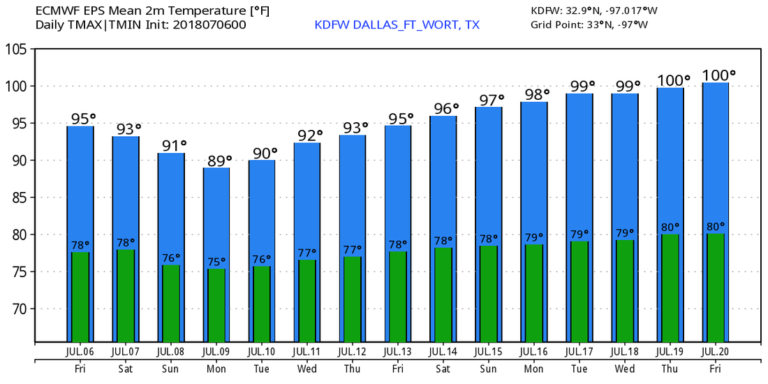 TROPICS BECOME ACTIVE - We have our first hurricane of the 2018 Atlantic Hurricane season. Hurricane Beryl is located near the Lesser Antilles and Africa in open water. It has maximum sustained winds of 80 mph, and is moving to the northwest at 15 mph. It is forecast to remain a hurricane as it impacts the lesser Antilles, and a hurricane watch may be required for the island. We expect this system to dissipate by Tuesday before it reaches Cuba with no threat to the U.S at all. 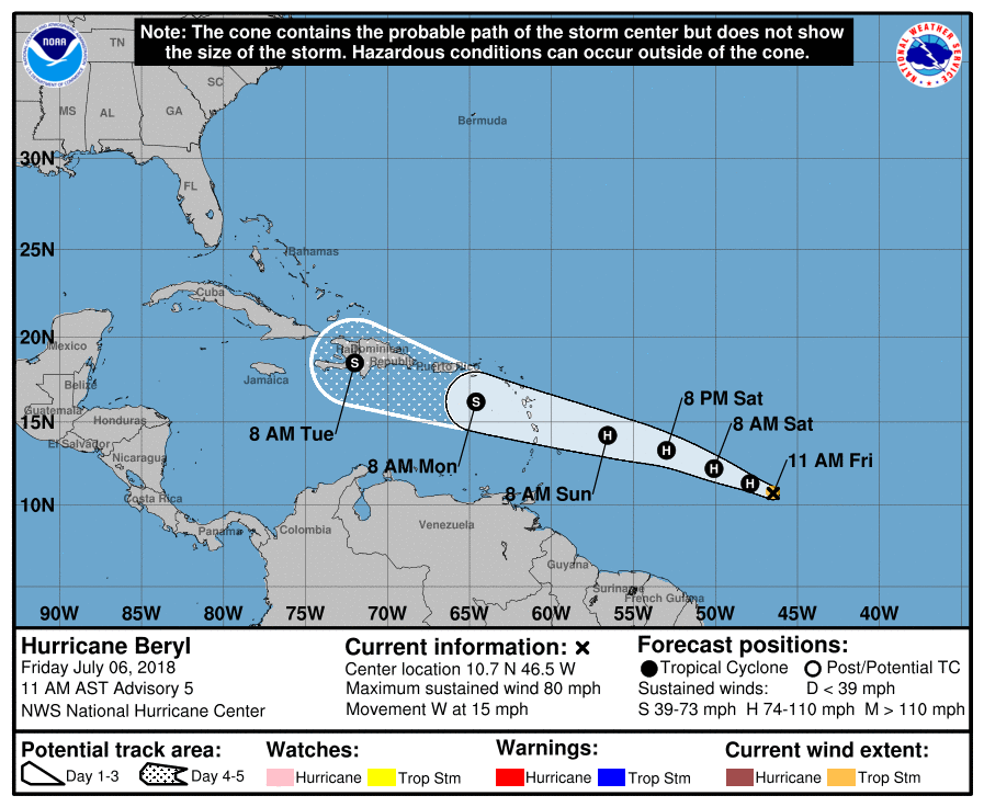 Meanwhile in the Central Atlantic, a disturbance that is a few hundred miles off of the Carolina coast has a 70% chance of becoming a tropical depression within the next two days. Global modeling suggests that this could become a tropical storm as it hugs the U.S. East Coast. This will not impact our weather in Texas.
*we are on a holiday schedule, so no Texas Weather Discussion Video until Thursday* Temperatures are currently in the middle to upper 80s this morning. Expect another full day of sunshine with highs in the low 100s this afternoon. This should be our last 100 degree day for a few days. ON THE RADAR - A weak impulse in the Northern Gulf is not too far from New Orleans. This is the same feature that brought an enhancement of showers and thunderstorms to Alabama and Mississippi yesterday. That feature will continue to move westward, and will supply as more moisture for Texas which could trigger a couple of isolated showers and thunderstorms during the latter half of this week. Otherwise, expect an enhancement in cloud clover over the next few days. INDEPENDENCE DAY - As that feature near New Orleans progresses westward, we will forecast a mix of sun and clouds with afternoon highs in the mid 90s. Don't let this fool you though. With an increase in moisture levels, humidity values will also be on the rise, which will also mean the heat index will increase, so don't get too caught up with cooler temperatures because the heat index will be in the triple digits still. We will also forecast a couple of isolated showers and thunderstorms mainly during the afternoon and evening hours. The best chance of any one spot getting wet throughout the day will be in the 10-20 percent range. The average high for July 4th for Dallas is 95. REST OF THE WORK WEEK - We will continue to forecast a mix of sun and clouds with an enhancement of clouds as we get towards the weekend. Isolated showers and thunderstorms will also be possible as moisture continues to advect from the east. Highs will be in the mid 90s with heat indices in the triple digits. THE WEEKEND - The coverage of showers and thunderstorms could get better starting Saturday as a weak surface front drifts to the south near North Texas. The front will stall somewhere in Central Texas on Sunday, but we will still maintain the chance of scattered showers and thunderstorms with a mix of sun and clouds during the day. The best chance of any one spot getting wet during the weekend will be in the 30/40 percent range. Highs will still be in the mid 90s, but humidity values will still be on the rise, which means heat indices will still be in the triple digits. NEXT WEEK - Showers will continue to linger into the early parts of next week, then the upper high located over the Central US will strengthen a bit, which means we could trend drier during the latter half of next week, and highs will go back into the upper 90s to the triple digits. 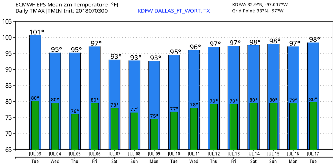 TROPICS - All is quiet in the Atlantic Basin, and tropical cyclone formation is not expected through the weekend. Meanwhile in the Eastern Pacific, Hurricane Fabio is a category two storm with maximum sustained winds of 105 mph. It is expected to become a major hurricane later today. It will continue to move to the northwest, away from land. 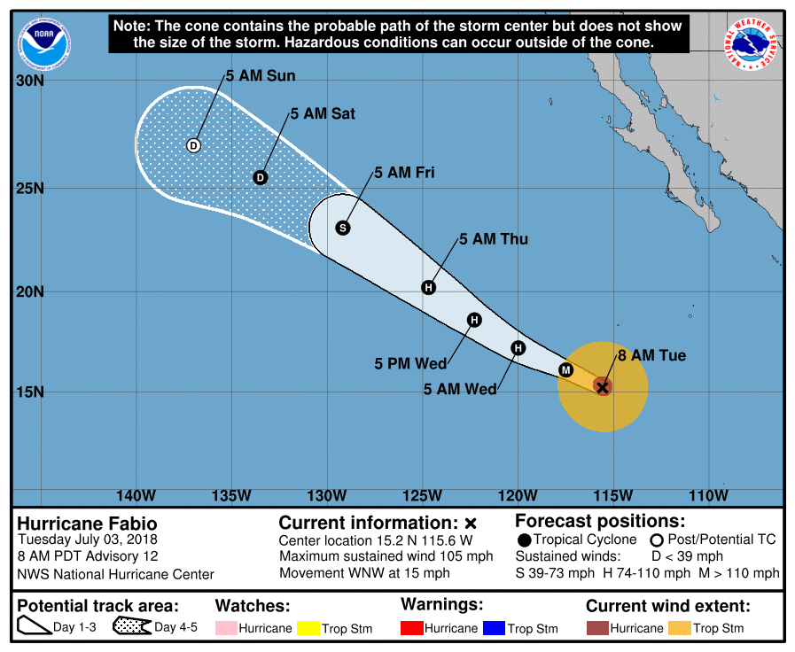 MOSTLY SUNNY - Once again a dry airmass encompasses much of the North Texas region this morning, and with breezy and humid conditions again, we expect a mostly sunny day with highs in the century range. Same deal on Tuesday; Hot, humid, mostly sunny with highs i the 100 degree range. WEDNESDAY THROUGH THE WEEKEND - A weak upper disturbance noted in the northern Gulf will emerge onto land today, which could help pull some moisture from the east to kick off a few isolated showers and thunderstorms during the latter half of the week as that impulse moves westward with time. Keep in mind that not everyone will see rain, and the best chance of any one spot getting wet is in the 20/30 percent range. Otherwise, expect a mix of clouds and sun with highs in the mid 90s. This will be the case through the weekend as the impulse moves more to the west. NEXT WEEK - The typical storm track stays way to the north (near the Canadian border). And with that, we will roll with a persistent forecast; hot, humid, abundant sunshine with highs in the mid to upper 90s. See the Texas Weather Discussion Video for more details. 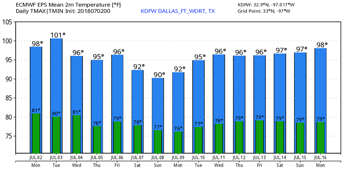 TROPICS - As a result of the Saharan Dust from Africa, the deep Atlantic Basin remain quiet, and no new tropical cyclones are expected within the next week.
|
Archives
April 2024
Categories |
 RSS Feed