
|
AVERAGE MORNING - It's a pretty decent morning here in the Lone Star State; temperatures are in the mid to upper 70s across the region this morning, pretty average for the last day of July. We do note that there will be some subsidence from the cold front and rain yesterday, and we will forecast a mix of sun and clouds today as a result. Afternoon highs will be close to 90 degrees, about six to seven degrees below the average temperature of 97 for late July. An isolated storm or two can't be ruled out during the afternoon. WEDNESDAY THROUGH FRIDAY - Look for much of the same weather for the next few days; mostly sunny, hot, and somewhat humid with highs in the mid 90s for the midweek. We start to heat back up next week. THE WEEKEND - Not much change. We continue to roll with a persistent forecast for the rest of the week and the weekend with no change in our current summertime weather pattern. We expect afternoon highs to be mostly in the upper 90s with mostly sunny skies. NEXT WEEK - We go back to triple digit heat as soon as next week hits with mostly sunny skies. Our current weather pattern stays mostly the same through most of the week. The GFS indicates much of the Deep South will stay dry for this time period as well. Expect highs in the upper 90s/low 100s with lows in the mid 70s. See the Texas Weather Discussion Video for more details. 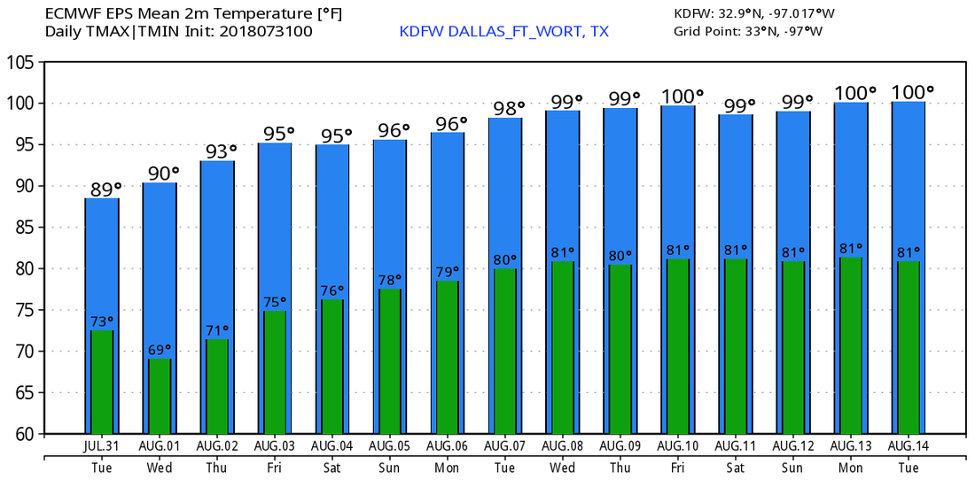 TROPIX - All remains quiet in the Atlantic Basin, and no new tropical cyclone development is expected for the next five days.
|
Archives
March 2023
Categories |
 RSS Feed
