
|
*we are on a holiday schedule, so no Texas Weather Discussion Video until Thursday* Temperatures are currently in the middle to upper 80s this morning. Expect another full day of sunshine with highs in the low 100s this afternoon. This should be our last 100 degree day for a few days. ON THE RADAR - A weak impulse in the Northern Gulf is not too far from New Orleans. This is the same feature that brought an enhancement of showers and thunderstorms to Alabama and Mississippi yesterday. That feature will continue to move westward, and will supply as more moisture for Texas which could trigger a couple of isolated showers and thunderstorms during the latter half of this week. Otherwise, expect an enhancement in cloud clover over the next few days. INDEPENDENCE DAY - As that feature near New Orleans progresses westward, we will forecast a mix of sun and clouds with afternoon highs in the mid 90s. Don't let this fool you though. With an increase in moisture levels, humidity values will also be on the rise, which will also mean the heat index will increase, so don't get too caught up with cooler temperatures because the heat index will be in the triple digits still. We will also forecast a couple of isolated showers and thunderstorms mainly during the afternoon and evening hours. The best chance of any one spot getting wet throughout the day will be in the 10-20 percent range. The average high for July 4th for Dallas is 95. REST OF THE WORK WEEK - We will continue to forecast a mix of sun and clouds with an enhancement of clouds as we get towards the weekend. Isolated showers and thunderstorms will also be possible as moisture continues to advect from the east. Highs will be in the mid 90s with heat indices in the triple digits. THE WEEKEND - The coverage of showers and thunderstorms could get better starting Saturday as a weak surface front drifts to the south near North Texas. The front will stall somewhere in Central Texas on Sunday, but we will still maintain the chance of scattered showers and thunderstorms with a mix of sun and clouds during the day. The best chance of any one spot getting wet during the weekend will be in the 30/40 percent range. Highs will still be in the mid 90s, but humidity values will still be on the rise, which means heat indices will still be in the triple digits. NEXT WEEK - Showers will continue to linger into the early parts of next week, then the upper high located over the Central US will strengthen a bit, which means we could trend drier during the latter half of next week, and highs will go back into the upper 90s to the triple digits. 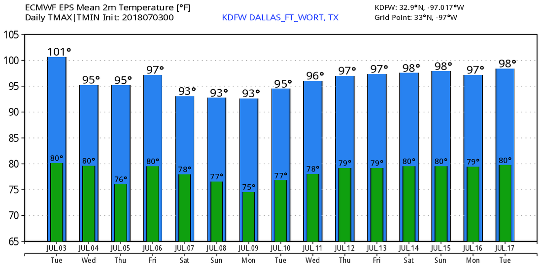 TROPICS - All is quiet in the Atlantic Basin, and tropical cyclone formation is not expected through the weekend. Meanwhile in the Eastern Pacific, Hurricane Fabio is a category two storm with maximum sustained winds of 105 mph. It is expected to become a major hurricane later today. It will continue to move to the northwest, away from land. 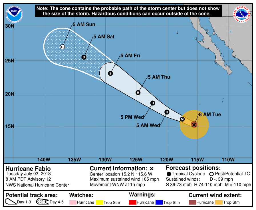 |
Archives
March 2023
Categories |
 RSS Feed
