
|
MORNING SUN, SOME PM STORMS - Today will be the last day of afternoon showers and thunderstorms for a while. We do start out nice and sunny this morning, but we will once again see the chance of isolated afternoon showers and thunderstorms during the afternoon and evening hours. Any thunderstorm that develops will most likely come between 12:00 and 8:00 PM, and the chance of one spot getting wet will be in the 10/20 percent range today. Elsewhere, expect mostly sunny skies with afternoon highs in the mid to upper 90s. THE WEEKEND - We go back to our regular summer time routine here in North Texas; sunny, hot, humid with highs in the upper 90s/low 100s during the afternoon. Most places stay dry. NEXT WEEK - Not much change for most of the week. In fact, we warm up a few degrees by midweek with highs near 102-103 by Wednesday afternoon. Then, an upper trough forms over the eastern half of the nation, which could cool us down a few degrees, but we won't notice any real difference. Dry air continue to filter in for the rest of the week... See the Texas Weather Discussion Video for more details. 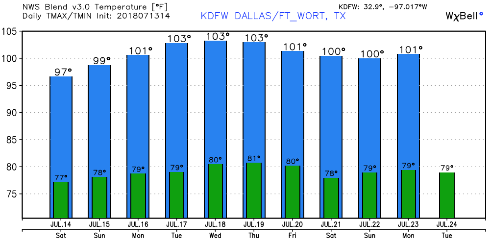 TROPIX - The Remnants of Beryl is several hundred miles to the east of the Carolinas, and continues to remain very disorganized. So disorganized that the NHC has lowered the chance of regeneration to 20 percent. One way or another, it will move northeast following Chris, posing no threat to the U.S. at all. The rest of the Atlantic Basin remains very quiet with nothing expected in the Gulf of Mexico for a long time.  |
Archives
March 2023
Categories |
 RSS Feed
