
|
MILD MORNING - Temperatures are in the upper 70s to low 80s this morning, very standard for this time of the year. I am just waiting for the days where we can start the morning off in the low 40s. Today will be another hot and humid day with more sun than clouds. Highs will be in the 94-98 degree range. Not much change in the forecast tomorrow; Highs will continue to be in the upper 90s with a mostly sunny sky with a few clouds; very typical late August weather. FOOTBALL WEATHER - For the high school football games happening in North Texas tomorrow, most games should be played under a clear sky with temperatures around 95° at kickoff, falling to the low 90s by the end of the fourth quarter. The Mansfield ISD main high schools will be traveling to Oklahoma tomorrow for their first inaugural Border Brawl games (7-7:30p kickoffs), scattered across the Tulsa/Broken Arrow area. The temperature will be in the 91-93° range at kickoff, falling to around 85° by the final whistle. THE WEEKEND - Not much change. We continue to remain mostly sunny and dry under humid conditions. Highs for the weekend will continue to be in the 93-99 degree range with a few clouds. NEXT WEEK - Global models have been hinting at some tropical moisture advecting from the Gulf during the very early parts of next week. If that were to be the case, our airmass would become unstable, which means we would introduce a chance of widespread, scattered showers and thunderstorms during the day with highs in the upper 80s to low 90s with cooler temperatures in the areas that experience the most rain. That rain would continue through at least Thursday. Meanwhile, the European model shows a tropical low impacting the Alabama coast, then making a hard left turn towards the Ark-La-Tex area, but does not reach North Texas. If that solution verifies, we would keep a dry forecast for much of next week with highs in the mid 90s. See the Texas Weather Discussion Video for more details. 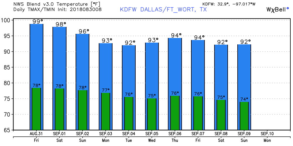 TROPIX - A tropical disturbance is continuing to move off the coast of Africa; the NHC subsequently gives it a 80 percent chance of developing over the next five days. This is still a few thousand miles away from the U.S., and it remains unknown if this will stay out in the open water, or impact any land masses. However, if this become a tropical storm, it's name will be Florence. 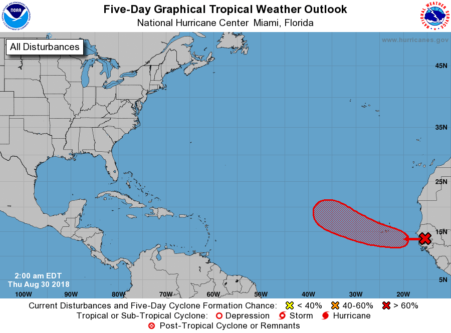 Global models are continuing to indicate the Atlantic Basin getting more active in the next few weeks in terms of tropical weather. This is perfectly normal as we are nearing the climatological peak month of hurricane season.
ANOTHER HOT AUGUST DAY - We are forecasting highs between 95-101 degree range this afternoon with a partly cloudy sky. We will see a few afternoon showers and thunderstorms try to develop as a surface front stalls near the Red River, but keep in mind that many communities will stay dry. The average high for DFW on August 28 is 97 degrees. REST OF THE WEEK - Not much change in the overall weather pattern; we stick with hot, humid afternoons with more sun than clouds. Highs will be in the mid to upper 90s each day. Heat levels will continue to drop a little bit each day. FOOTBALL WEATHER - For the high school football games going on this Friday, temperatures will start out around 95 at kick off, falling to the 89-92 degree range by the end of the fourth quarter. The Mansfield ISD schools will be traveling to the Tulsa area in Oklahoma for their first Inaugural Border Brawl games this Friday. All of the games have kickoff times around 7-7:30p. Temperatures should be around 92 by kickoff, falling to around the upper 80s by the final whistle. THE WEEKEND - September 1 marks the first day of Meteorological Fall, but you know Texas, it doesn't just magically turn cool, sadly. It will be only a couple degrees cooler with highs around 95 with mostly sunny skies. NEXT WEEK - Global models have been hinting some tropical moisture advecting from the Gulf, so we will slightly mention the chance of scattered showers and thunderstorms during the week. This would also mean slightly cooler temperatures with more clouds than sun, but "we'll believe it when we see it". Expect highs to remain in the middle 90s for most days. See the Texas Weather Discussion Video for more details. 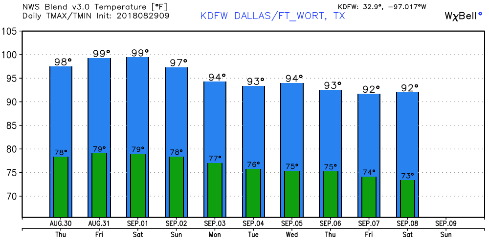 TROPIX - The NHC is monitoring a wave located off of the African Coast, they only give it a low (30%) chance of developing during the next five days. Development of this disturbance could be somewhat hard as cooler waters could hinder development. But, as we get to the peak month of hurricane season, anything could happen, so we will continue to monitor. The rest of the Atlantic Basin is quiet. 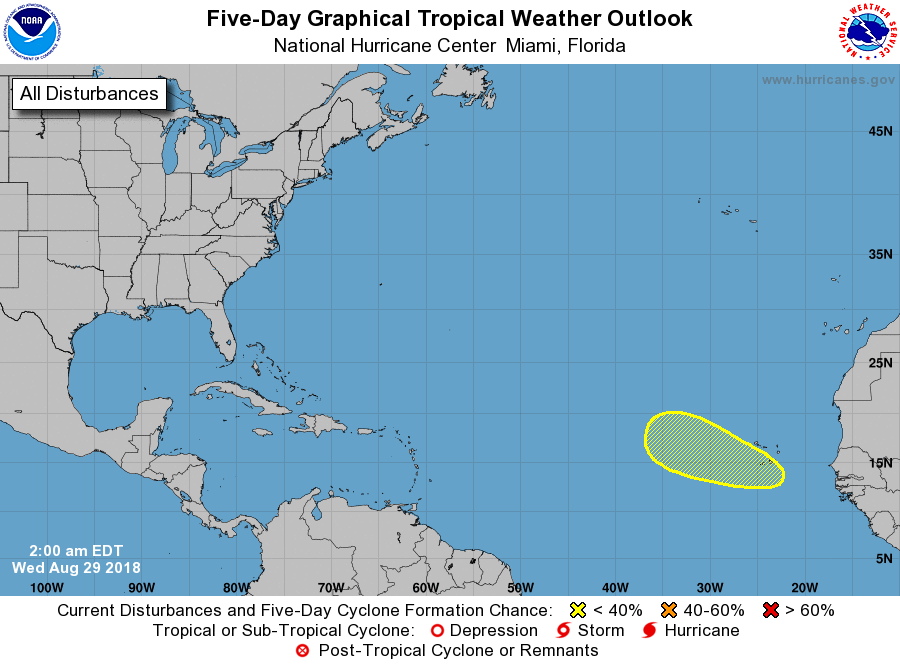 HOT AND DRY - The surface maps this morning shows broad ridging over the south-central U.S. with the more focused ridging over the south-eastern part of the country, which means hot weather will persist for North Texas. With abundant sunshine, we expect highs in the upper 90s again this afternoon. A seabreeze shower or two is possible for our southern counties. REST OF THE WEEK - Not much change tomorrow; hot and dry weather will continue with highs in the upper 90s. A cold front starts to approach from the north, but only makes it to Central Oklahoma. A few showers and thunderstorms are possible for mainly our northern counties along the Red River, but a couple can't be ruled out here. But the odds of any one spot getting wet are only about one in ten... We will continue with a dry forecast for Thursday and Friday with more sun than clouds with highs in the middle to upper 90s. FOOTBALL WEATHER - Summit High School is kicking off their first football game of the season with their Inaugural Border Brawl game against Page High School in Sand Springs, Oklahoma this Friday (7p kickoff). Highs for the game will be around the low 90s, falling into the upper 80s by the final whistle. Lake Ridge High School subsequently has their first game of the season in Tulsa against Union High School on Friday (7p kickoff). Again, temperatures will be in the low 90s at kickoff, falling to around 88 by the end of the fourth quarter. Mansfield High School takes on Broken Arrow High School this Friday (7p kickoff). We continue to forecast dry conditions for the game with temperatures at around 93 starting off, falling into 87 by the final whistle. Timberview High School also travels to Oklahoma to compete with Bixby High School this Friday (7:30p kickoff). As the sun sets, temperatures will be around 90 by kick off, falling to around 85 by the end of the fourth quarter. THE WEEKEND - Meteorological Fall begins this Saturday, September 1st. However, you must know that it does not magically turn cooler once we hit September. The weekend will be hot and humid as we deal with abundant sunshine on both days. Highs will be around 94-97 on both days. NEXT WEEK - Not much change. Mostly sunny days with little change in the weather pattern. Highs will stay close to 95 degrees for much of next week; no signs of a pattern changing cold front for now. See the Texas Weather Discussion Video for more details.  TROPIX - The Atlantic Basin continues to remain amazingly quiet for this time of the year, and tropical cyclone formation is not expected this week.
WARM MORNING - Temperatures are in the upper 70s to low 80s across the region this morning. Today will once again be very hot with abundant sunshine and humid conditions. Highs will be in the upper 90s this afternoon. Some places could actually touch 100 degrees again. Since the upper high pattern will continue to hold for much of North and Central Texas, we will continue to roll with a persistent forecast to end the month of August; hot, humid, very sunny with highs in the mid to upper 90s. There will be little to no change in the forecast as we head into September. The chance of any isolated showers or storms on Wednesday is so small, it is not even worth mentioning in a formal forecast, so we will continue to keep Wednesday and Thursday dry for the time being. THE WEEKEND - Our first days of September will feature much of the same weather over the past several days; hot, humid, mostly sunny with highs in the mid 90s. Morning lows will be in the mid 70s with a clear sky. NEXT WEEK - Not much change; we will still continue to roll with a persistent weather forecast for next week. Though not as hot, highs will continue to be in the mid 90s for much of the week with mostly sunny skies, which is still above average for early September. See the Texas Weather Discussion Video for more details. 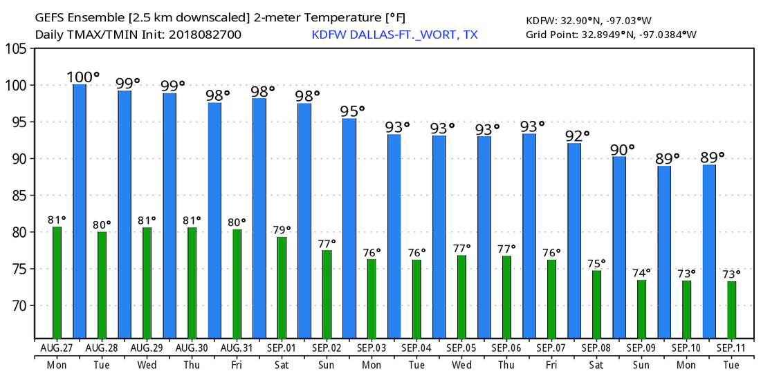 TROPIX - All is quiet in the Atlantic Basin, and tropical cyclone formation is not expected for the next two to five days. Although, we are continuing to watch some wave action near the African coast. We are approaching the climatological peak of hurricane season, so we always need to keep a watchful eye for even the slightest indications.
Our current upper air pattern brings the type of weather to North Texas that doesn't really change much. We will continue to forecast mostly sunny skies with a couple of clouds. Heat levels will be on the rise again, and highs will be closer to 100° today. The overall weather for the weekend will stay the same as well. We will continue to forecast very hot days with sunny afternoons. Highs will be mostly in the upper 90s for the weekend. NEXT WEEK - And the dry pattern stretch continues through most of next week as well as we see no evidence of rainfall for at least the next ten days. Expect highs to be in the mid to upper 90s for all of next week with mostly sunny skies. Lows will be in the mid to upper 70s. See the Texas Weather Discussion Video for more details.  TROPIX - Hurricane Lane is affecting much of the Hawaiian Islands but continues to weaken just to the west of there. It will weaken to a category two later today. The main impacts from this storm will include lots of heavy rain and flooding.
In the Atlantic, a well organized wave is emerging from the coast of Africa this morning, but lots of dry air and cooler water means there is no chance of development this weekend. The rest of the Atlantic Basin remains quiet. ONE YEAR AGO TODAY - Hurricane Harvey was approaching the middle Texas coast. It would make landfall at around 10PM the next day between Port Aransas and Port O'Connor. Hurricane Harvey is tied with 2005's Hurricane Katrina as the costliest tropical cyclone on record, inflicting 125 billion dollars in damage, primarily from catastrophic flooding in the Houston area. It was the first major hurricane to make landfall in the US since Wilma in 2005, ending a record 12-year streak in which no hurricanes made landfall at the intensity of a major hurricane throughout the country. In four days, many areas received more than four feet of rain as the system slowly meandered over eastern texas and adjacent water, causing unprecedented flooding. DRY MORNING - No rain on the radar this morning across North Texas as unusually dry air for late August covers much of the state of Texas. The sky will be mostly sunny today, and highs will be in the mid to upper 90s. FRIDAY AND THE WEEKEND - Not much change. We warm substantially tomorrow with more spots reaching the triple digits. Humidity levels will very slowly increase. Otherwise, expect mostly sunny skies with afternoon highs in the upper 90s range between 95 and 99. NEXT WEEK - Routine summer-time weather is the main headline for much of next week as the upper high pattern does not change much; mostly sunny with a few clouds with highs mostly in the mid to upper 90s with gradually increasing humidity levels. See the Texas Weather Discussion Video for more details.  LANE DANGEROUSLY CLOSE TO HAWAII - Hurricane Lane in the Central Pacific is now down to a high-end category four with maximum sustained winds of 145 mph. It will continue to gradually weaken as the center will pass just to the west of Hawaii. Despite the weakening and no direct landfall, persons should expect a dangerous impact in the islands with about a foot/2 feet of rain, dangerous storm surge and strong wind damage. 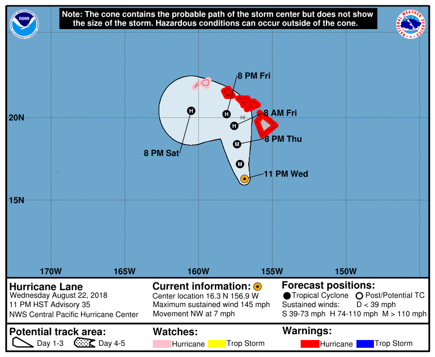 UPPER LEVEL HIGH - Anomalously dry air will continue to circulate over North Texas for the next several days as our upper high pattern continues, which will set the stage for mostly sunny, very hot days and mild nights. Highs will be in the mid to upper 90s with lows in the 70s. An isolated shower or two is definitely not out of the question from time to time, but most of the region remains rain free for the next several days. THE WEEKEND - Not much change. We get somewhat hotter over the weekend as the upper high strengthens. We will roll with a persistent forecast of mostly sunny, very hot days with afternoon highs in the mid to upper 90s. Some places could actually reach 100° by Friday and Saturday. NEXT WEEK - The upper high pattern stays in Texas for a while, so look for mostly sunny and hot afternoons each day with highs in the mid to upper 90s, fairly anomalous for late August. See the Texas Weather Discussion Video for more details. 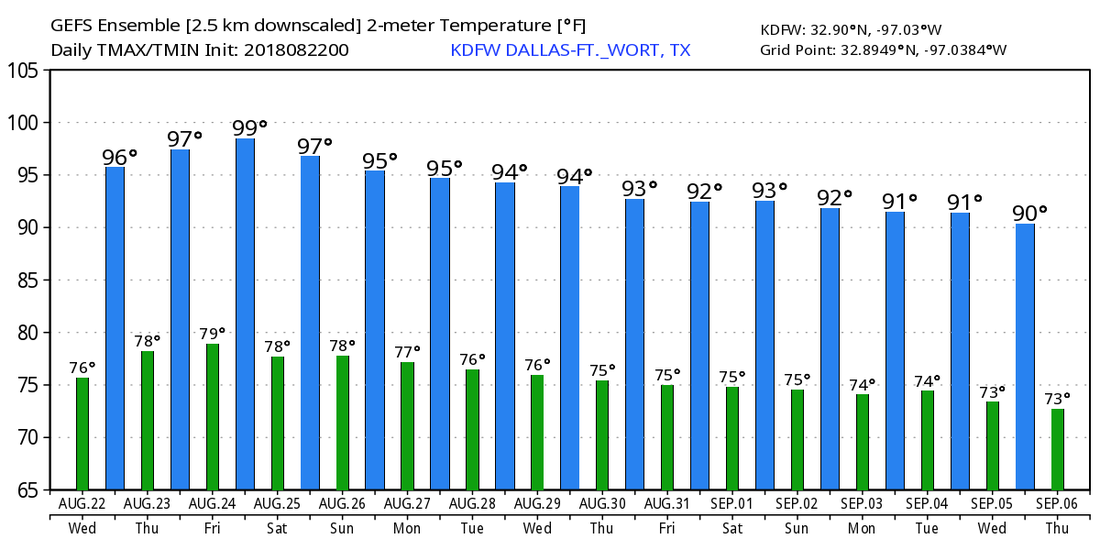 HURRICANE LANE NEARS HAWAII - Hurricane Lane is now a Category Five storm with maximum sustained winds of 160 mph. It will weaken as it continues to move northwest, but the NHC track will have Lane pass just to the west of the islands, but still dangerously close for major impacts. Just know that if the center wobbles to the north by just a little bit, that could put the island under a real emergency. Rain amounts of about a foot are likely, with isolated amounts of two feet possible. Dangerous rip currents and storm surge is expected, along with very, very strong winds. 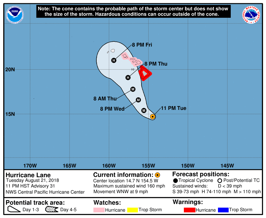 SURFACE ANALYSIS - We have a deep trough over the nation's midwest sector this morning, with a surface low over that same location. It is located on the borders of Iowa, Illinois, and Missouri. The trailing cold front (which is anomalous for late August) is in San Antonio, continuing to move south. Drier air is filtering in behind the front, and much of Texas should be dry for the next week, as a result. For North Texas, everyday will feature more sun than clouds with highs in the middle 90s during the afternoons. Morning lows will be in the mid 70s, very typical for August. TOMORROW THROUGH FRIDAY - Not much change. We stay very sunny Wednesday and Thursday with afternoon highs between 95 and 98. Then on Friday, highs will get even closer to the 100° mark as the upper high continues to strengthen over Texas. Each day will be sunny and hot. Expect morning lows in the middle to upper 70s for the next three days. THE WEEKEND - We will forecast a very sunny and hot weekend with more sun than clouds with dry air still in place. Highs will be in the upper 90s all weekend, with lows in the upper 70s. NEXT WEEK - The upper high continues to stick around in our area for much of next week. This means a majority of next week will continue to remain dry. Look for mid to upper 90s in the afternoon. See the Texas Weather Discussion Video for more details.  TROPIX - Atlantic Basin continues to remain very quiet with no new tropical development expected this week. We are entering the peak of the Atlantic hurricane season, but cool water, dry air, and shear is precluding any development right now.
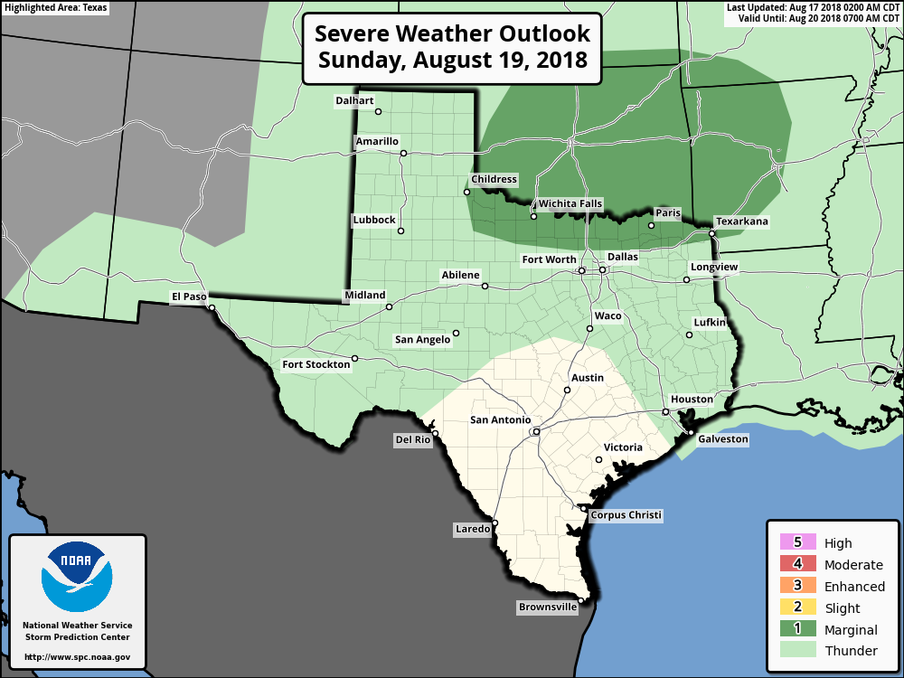
*no Texas Weather Discussion Video this morning* RADAR CHECK - The radar only shows a small cluster of showers and thunderstorms that is located just to the north of Eastland and Ranger, moving southeast. They should continue to move to the southeast with time, but, we will need to keep a watchful eye of new development of showers and thunderstorms this morning, but nothing widespread. Today will feature typical mid to late August weather - hot with a mix of clouds and sun. Afternoon highs will be in the mid 90s today. REST OF THE WEEK - The surface low well to the north along with the cold front will continue to move east throughout the week. We will have another one of those weeks where the weather will not change much. Each day will feature a mostly sunny sky with a few clouds with highs in the low 90s/mid 90s range. We can't rule out the possibility of an isolated shower or two during the day. THE WEEKEND - The overall pattern really does not change much. We continue to stay relatively dry for the weekend with highs in the mid 90s and morning lows in the upper 70s again, very average for late August. NEXT WEEK - The early part of next week will continue to be dry as well as the overall synoptic scale does not change at all. Similar to this week, each day will feature a mix of sun and clouds with afternoon highs in the middle 90s with morning lows in the mid 70s, which isn't too far from seasonal averages here in North Texas. 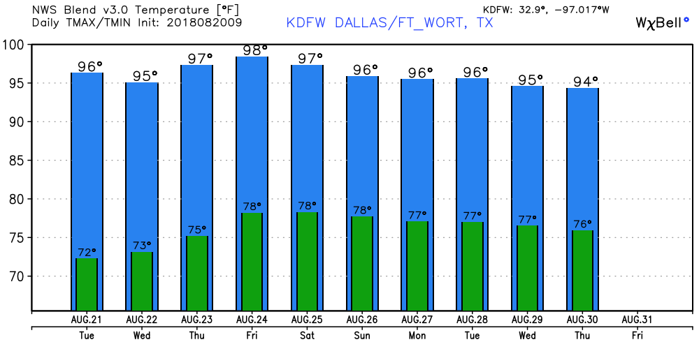 TROPICS - Following Tropical Storm Ernesto, which became post tropical two days ago, the rest of the Atlantic Basin continues to remain quiet for the next 48 hours to five days, which is very good considering how August and September are usually the peak months of hurricane season.  WARM MORNING - Temperatures are mostly in the upper 70s to low 80s this morning across North Texas. Today will be no different than the past few days; mostly sunny, hot and humid with temperatures in the upper 90s. I doubt we will hit the triple digits today. A surface front approaches from the north this morning which will set off the chance of mainly isolated showers and thunderstorms today and through the weekend. The best coverage will be confined mainly for northern counties near the Red River. A few strong thunderstorms will be possible in those counties. In fact, the SPC has a "marginal risk" of severe storms defined for our northern counties today and Sunday. The greatest threats will range from very small hail to gusty winds at times.
This will basically be the weather situation for the weekend with the stalled surface front just to the north of the Red River. The sky will feature a mix of sun and clouds with a few passing isolated showers and thunderstorms with a few strong storms in the mix. A few storms could be on the strong side as mentioned above. Highs will be in the mid to upper 90s. NEXT WEEK - A cold front pushes through North Texas Monday morning, and scattered showers and thunderstorms will become possible as a result. I'd say the best chance of any one spot getting wet is in the 40 percent range. Rain amounts today and throughout much of next week will be in the in the 1/2 inch - 0.8 inch range for much of North Texas. After the cold front comes through, drier air and cooler temperatures will cover much of the region thereafter. Tuesday looks immediately dry with highs in the low 90s and lows in the low 70s. See the Texas Weather Discussion Video for more details. 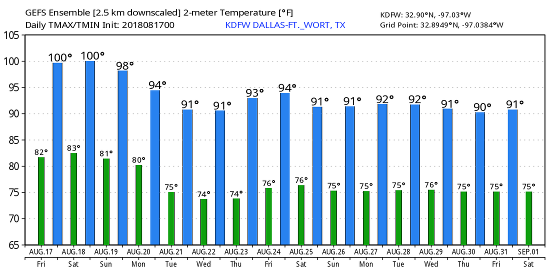 TROPIX - Tropical Storm Ernesto is located in the Northern Atlantic, and will become post-tropical by Saturday afternoon, and a wave approaching the Windward Islands has a 20 percent chance of development over the next five days as a result of dry air and shear. The rest of the Atlantic Basin remains quiet.
*no Texas Weather Discussion Video today* A very quiet morning across the Lone Star State. The sky is mostly clear with a few clouds about with showers and thunderstorms non-existent. Temperatures are in the upper 70s/low 80s this morning. We expect an increase in the temperature over the next few days as humidity values continue to stay very high. Each day will feature more sun than clouds with highs in the mid to upper 90s. FRIDAY AND THE WEEKEND - Not much change occurs on Friday and Saturday as we hold our hot weather pattern for those two days. Each day will be mostly sunny with highs in the upper 90 degree range. A cold front is due in here by Sunday afternoon, which will help with the temperature quite a bit. We will mention the chance of isolated showers and thunderstorms Sunday afternoon through Monday morning. This won't be a washout like what we saw last week, and highs will be in the mid 90s on Sunday. NEXT WEEK - The latest GFS runs suggest cooler, drier air filtering in the Plains next week, so we will accordingly mention a dry forecast for much of the upcoming week. A surface boundary moves east into North Texas on Friday, which will be another chance of showers and thunderstorms before the weekend begins. Highs each day will be in the low 90s.  TROPIX - Subtropical Storm Ernesto is located over the Northern Atlantic with winds of only 40 mph. It will continue to move northeast, away from any land. Another wave is located east of the Windward Islands. The NHC is only giving a 10 percent chance of developing within the next two days. It is expected to continue to move east towards the Caribbean as an open wave as environmental conditions do not favor development. The rest of the Atlantic Basin remains quiet. 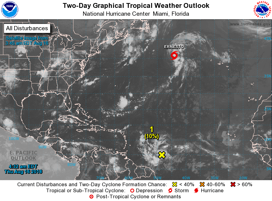 DRY MORNING - For the first time in a few days, the radar is actually clear of any heavy downpours this morning, pretty fitting for the first day of school for some of us. There were some showers just to the northeast of College Station that will eventually fade away during daybreak. Temperatures are mostly in the mid to upper 70s this morning, but we will warm to the mid 90s later today with a mix of sun and clouds. Not much change in the weather tomorrow either. The afternoon will be hot and humid with highs in the middle to upper 90s. An isolated shower or two during the afternoon is never ruled out with lingering moisture in the state. FRIDAY AND THE WEEKEND - Our weather really doesn't change much for the weekend. Expect hot and humid days with more sun than clouds. It will continue to feel rather humid with highs in the mid 90s all weekend, certainly better than 100° heat. NEXT WEEK - An upper trough in the northeastern U.S. will push a surface front to the south which will lead to isolated showers and storms during the early part of next week. Rain chances will stay low with the best chance of any one spot getting wet in the 20 to 30 percent range. Look for highs in the low 90s for most of next week. See the Texas Weather Discussion Video for more details. 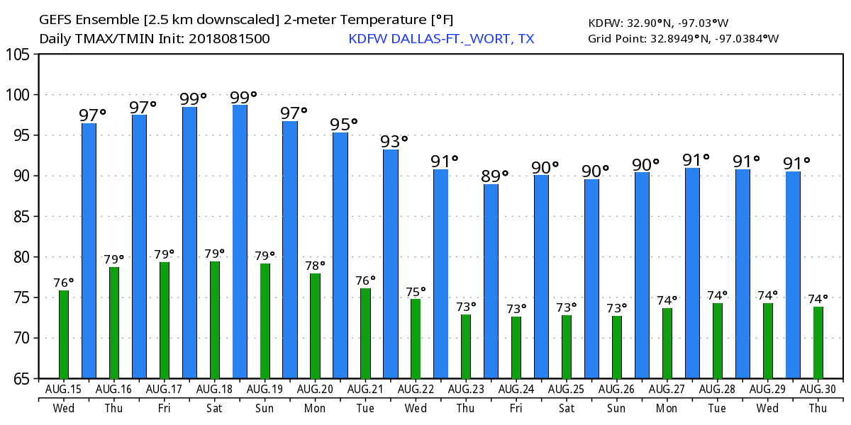 TROPIX - Subtropical Depression Five formed earlier this morning in the Central Atlantic. It will become Subtropical Storm Ernesto later today. The good news is that it will kick off to the northeast, away from the U.S. The rest of the Atlantic Basin remains very quiet. 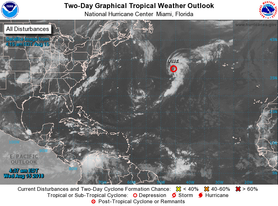 RADAR CHECK - Lingering showers and thunderstorms continue to move to the northeast this morning. They will continue to move rapidly to the northeast this morning, mostly clearing out by the afternoon. Temperatures are generally in the low to mid 70s this afternoon.  TOMORROW AND THURSDAY - We really start to dry out by the latter half of this week at the trough lifts more to the north. Each day will feature a mix of sun and clouds with afternoon highs in the mid 90s. A couple of isolated, "pop-up" showers and thunderstorms will still remain possible during the afternoon, but mostly communities stay dry. FRIDAY AND THE WEEKEND - Not much change for the weekend. We will continue to stick with a dry forecast with a mix of sun and clouds. Some moisture could find its way into some parts of North Texas, so an isolated storm or two is not ruled out. Highs each day will be in the mid 90s. NEXT WEEK - Global models have been indicating a trough setting up in the Corn Belt which will aid in pushing a cold front to the south on Tuesday. This would of course mean increased chances of scattered showers and thunderstorms and cooler temperatures by a few degrees. The latter half of next week remains unsettled as a result, and we will continue with a chance of at least isolated showers and storms through at least Thursday. Highs each day will be in the low 90s. See the Texas Weather Discussion Video for more details. 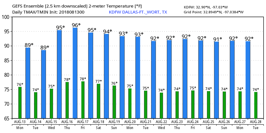 TROPIX - A small disturbance in the Central Atlantic has a 40 percent chance of developing within the next 48 hours. This could become a subtropical or tropical cyclone before late Thursday, when it moves northeast into cooler water. This poses no threat to land. The rest of the Atlantic Basin remains quiet.
RADAR CHECK - Scattered showers and thunderstorms continue to move to the northeast this morning, affecting mostly the northern portions of the DFW metro... 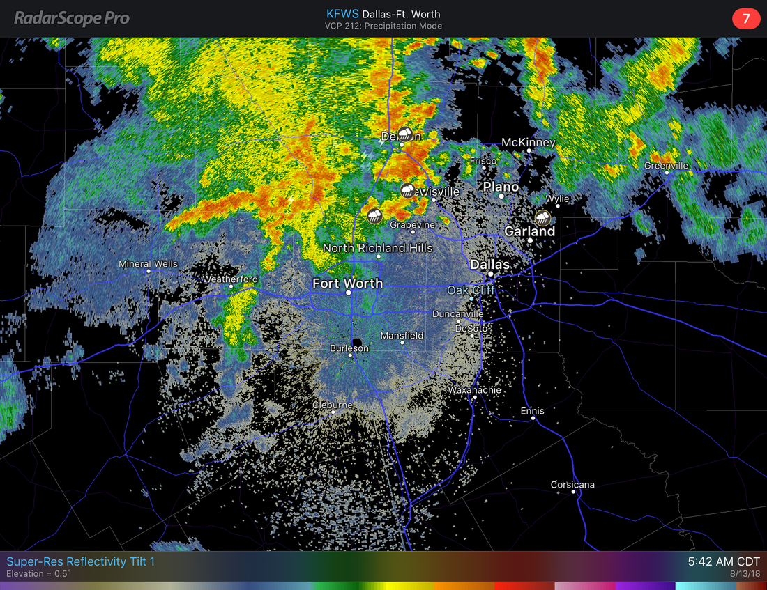 The good news about these storms is that they are moving northeast at around 25 MPH, so we don't have to worry about flash flooding too much this morning. But flooding in low-lying areas is definitely not out of the question so take it slow on the roads heading to work and school this morning. Redevelopment of showers and thunderstorms is likely after 1PM, the best chance of any one spot getting wet today will be in the 70/80 percent bracket. We will stay cloudy for much of day with afternoon highs in the mid 80s, about ten degrees below average for mid August. TUESDAY - We will see a cluster of showers and thunderstorms develop during the morning hours, but nothing widespread like what we have seen this weekend. The majority of North Texas will stay dry Tuesday with mostly cloudy skies. Highs will be in the upper 80s to low 90s, still way below the average high for mid August. WEDNESDAY THROUGH FRIDAY - We dry out during the latter half of this week as the stalled upper low finally moves northeast. There will still be some clouds lying around, but we should see more sun than clouds during the day. Highs will be in the low to mid 90s in the afternoon, back to seasonal averages for this time of the year. Better than 100° heat. THE WEEKEND - Not much change. We will stick with a dry forecast for the weekend with a mix of sun and clouds during the afternoon with highs in the mid 90s during the peak of the day. We might see a shower or two but that's really about it. NEXT WEEK - Another surface front may edge some parts of North Texas by early next week, but won't be enough for widespread showers and thunderstorms. So we will continue to forecast a mix of sun and clouds with occasional isolated showers and storms during the afternoon. Highs will be in the low 90s as we get closer and closer to September, the first month of Meteorological Fall. See the Texas Weather Discussion Video for more details.  TROPIX - There is a wave located in the Northern Atlantic that is barely generating showers and thunderstorms. The NHC gives it a 10 percent chance of development within the next 48 hours to five days, but more than likely it just stays an open wave. The rest of the Atlantic Basin remains very quiet for this time of the year. 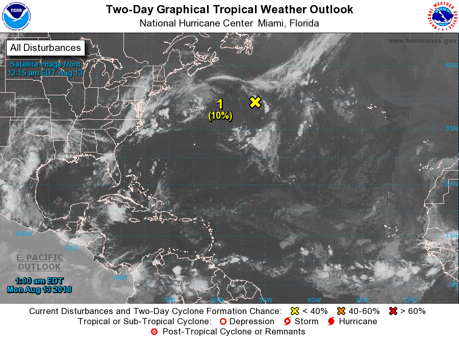 After a long, dry stretch of weather across North Texas, the pattern is changing and rain becomes likely, as early as tonight.
Our initial cold front is still north of the area, and will increase the chances of showers and storms heading into the late evening and overnight hours. A small area of showers/storms is located to the north of the metroplex as of 6pm, and will slowly drift SE and shouldn’t affect the metroplex, but may affect our NE counties. New storms are expected to fire up late tonight and the coverage will be near 50-70%. This will linger into the morning hours tomorrow. Subsidence behind the main morning rain will make it a tricky afternoon forecast, but we should at least see scattered thunderstorms during the afternoon hours tomorrow. More rain moves in Friday morning and will continue through the day. More waves will occur through Monday. The highest totals will be north of I/20 through Monday with 1-4” likely with locally higher totals possible. Highs the next several days may struggle to reach 90°F. Due to some weak ridging, our far southern counties and Central Texas totals will be much lower, but any outflows could ignite storms in Central Texas. Less than 1” is expected near the Waco area and generally less than 1/2“ towards the Austin area. However, if any boundaries linger there then some hit or miss storms aren’t ruled out. We should dry out by Tuesday and Wednesday with temperatures warming up. -Jonathan Williams *no Texas Weather Discussion Video today* AVERAGE MORNING - It is an average August morning here in North Texas with temperatures in the upper 70s/80 in the urban core with mid 70s elsewhere, right at seasonal averages in terms of lows for this time of the year. The radar is actually clear this morning, and once again we will see mostly sunny skies with highs in the mid to upper 90s, right at seasonal averages. THE WEEKEND - Not much change. We continue to stay right or a little above seasonal averages through the weekend with afternoon highs in the mid to upper 90s with morning lows in the upper 70s again. NEXT WEEK - Look for hot days during the early part of next week mostly sunny skies with highs at or near the triple digits. The global models indicate the potential progression of a surface front through our area during the latter half of next week. If it stalls, we would have decent chances of scattered showers and thunderstorms everyday through next weekend. It would also mean that we would go back to average temperatures after Tuesday/Wednesday. But as I say with nearly every situation like this, we'll believe it when we see it. However, the Climate Prediction Center says there is a forty-percent chance of seeing above average rainfall totals from August 8 through 12. They also follow through with that in their 8-14 day outlook. Rain chances are starting to become more frequent as we head into our last full month of summer. 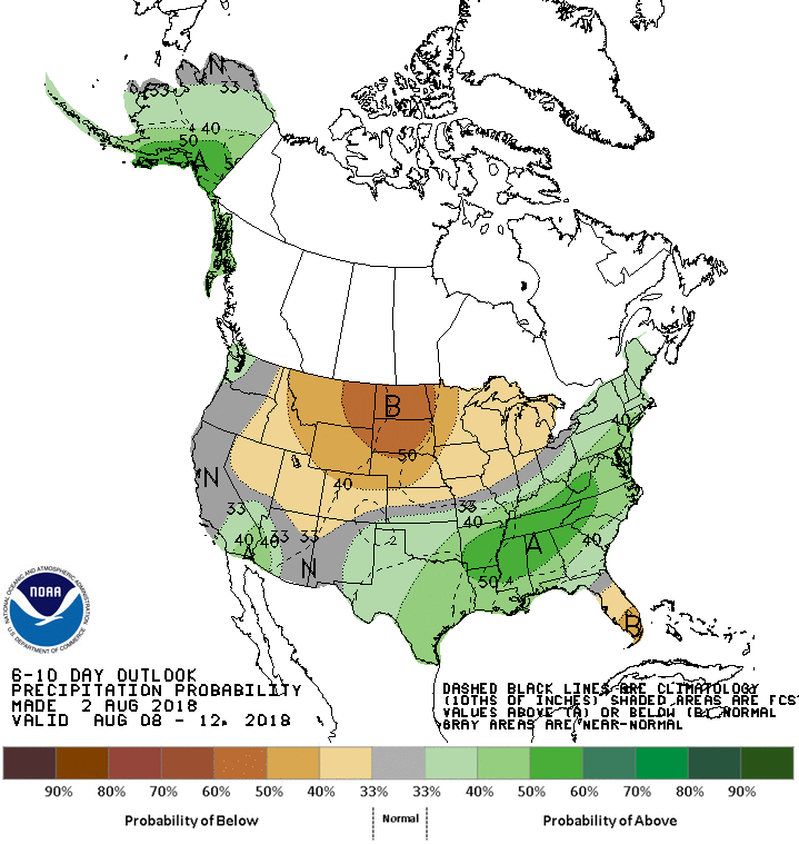 TROPIX - The Atlantic Basin continues to remain very quiet, with no tropical cyclone development expected within the next five days.
COOL START - It feels really good this morning; temperatures range from the mid 60s to mid 70s across the region. Add a nice little breeze to it and it will be perfect weather for any outdoor activity for this time of the year. While it is fun to fantasize about the cooler morning weather, it is not going to last that long today. We will warm up to the mid 90s this afternoon with mostly sunny skies, still a few degrees below our usual average high for early August. THE REST OF THE WEEK AND THE WEEKEND - We have once again entered the time of the year where the weather really does not change much. We will continue to forecast more sun than clouds with afternoon highs in the mid to upper 90s with morning lows in the upper 70s to low 80s. NEXT WEEK - It really looks like most of next week will feature much of the same weather as well; hot, dry, mostly sunshine with highs in the upper 90s to low 100s. Not much will change with our weather pattern for much of next week. See the Texas Weather Discussion Video for more details.  TROPIX - All is quiet in the Atlantic Basin, and no tropical cyclone development is expected through the weekend. Keep in mind that the Climatological peak of hurricane season typically comes in mid September.
|
Archives
April 2024
Categories |

 RSS Feed