
|
WARM MORNING - Temperatures are in the upper 70s to low 80s across the region this morning. Today will once again be very hot with abundant sunshine and humid conditions. Highs will be in the upper 90s this afternoon. Some places could actually touch 100 degrees again. Since the upper high pattern will continue to hold for much of North and Central Texas, we will continue to roll with a persistent forecast to end the month of August; hot, humid, very sunny with highs in the mid to upper 90s. There will be little to no change in the forecast as we head into September. The chance of any isolated showers or storms on Wednesday is so small, it is not even worth mentioning in a formal forecast, so we will continue to keep Wednesday and Thursday dry for the time being. THE WEEKEND - Our first days of September will feature much of the same weather over the past several days; hot, humid, mostly sunny with highs in the mid 90s. Morning lows will be in the mid 70s with a clear sky. NEXT WEEK - Not much change; we will still continue to roll with a persistent weather forecast for next week. Though not as hot, highs will continue to be in the mid 90s for much of the week with mostly sunny skies, which is still above average for early September. See the Texas Weather Discussion Video for more details. 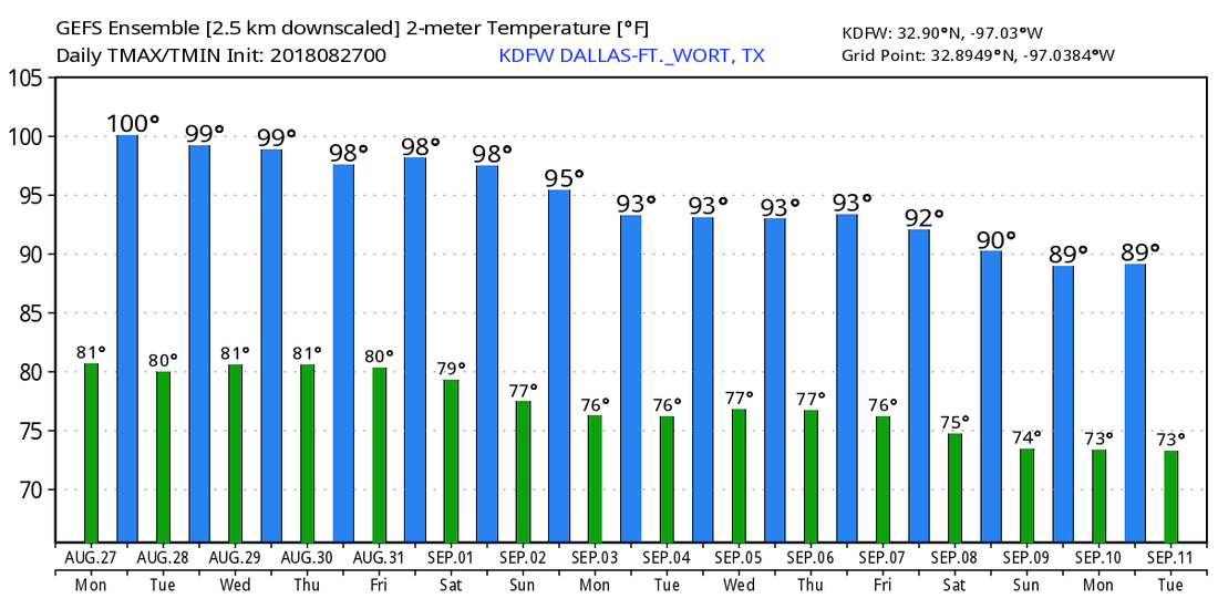 TROPIX - All is quiet in the Atlantic Basin, and tropical cyclone formation is not expected for the next two to five days. Although, we are continuing to watch some wave action near the African coast. We are approaching the climatological peak of hurricane season, so we always need to keep a watchful eye for even the slightest indications.
|
Archives
March 2023
Categories |
 RSS Feed
