
|
VERY ACTIVE AFTERNOON - You will want to pay special attention to the weather afternoon as we have the threat of all modes of severe storms this late afternoon into tonight. MIDDAY LULL - As forecast, most of the morning clouds have cleared the region, leaving us with a mostly sunny sky. With the sunshine, temperatures are rising to the middle 80s, making for a very unstable atmosphere. Some places could easily reach the low 90s this late afternoon, which is ten degrees above our average high for this time of the year. It will feel more like an humid, early summer day this afternoon. "SURPRISE" SEVERE WEATHER RISK THIS EVENING - Since the cold front decided it wanted to arrive six hours later than previously forecast, we now have a volatile airmass for severe storms to initiate in. As dynamic support increases, we will have a threat of severe weather through tonight. PLACEMENT - The Storm Prediction Center has defined an "enhanced risk" (level 3/5) of severe weather for all of the immediate metroplex which includes areas along and to the north of US-67 between Johnson and Ellis counties, with the standard "slight risk" (level 2/5) for the rest of the region. The highest tornado probabilities exist within the enhanced risk zone, and a strong/violent tornado is not out of the question here. 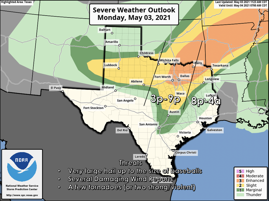 TIMING: I expect storm initiation to take place somewhere to the west of the metroplex at around 3p this afternoon. The main threat of severe weather for most of the population will come at around 6-9p with the threat for our eastern counties at around 8p, lasting through the pre-dawn hours Tuesday morning. THREATS - All modes of severe weather are possible, mainly including the threat for very large hail and the possibility of a few tornadoes. Based on the volatile airmass, there could be one or two strong/violent tornadoes (EF2-EF5). In addition, wind damage will also be a concern as well. CALL TO ACTION - Today is day where you and your family need to keep ready for severe thunderstorms. Be sure you have multiple ways of receiving warnings. NEVER RELY ON A TORNADO SIREN. First, make sure you have a NOAA Weather Radio. Every home in North Texas needs one as they work off of their own network, making them very reliable. On your phone, make sure you have WEA (Wireless Emergency Alerts) enabled on your phone. To make sure of this go to Settings > Notifications > scroll all the way down to the bottom to ensure that "Emergency Alerts" are enabled. Find the safest place in your home. It is typically in a small room, on the lowest floor, near the center of your house, away from windows. In that safe place, have helmets for everyone, airhorns (in case you are injured and need to alert first responders on site), and hard-sole shoes (if you must walk over tornado debris). If you live in a mobile home, you can not stay put during a tornado warning. Identify the nearest location of a shelter or safe place, and know how to get there at a moments notice. TUESDAY THROUGH FRIDAY - Lingering showers and storms should end early in the day on Tuesday, followed by clearing as drier air returns. The weather should remain dry for most of the region with highs in the upper 70s to low 80s. THE WEEKEND - Both days should feature a good supply of sunshine with a high between 85-90. Southerly winds will increase on Saturday. NEXT WEEK - A stalled surface front will keep at least a slight chance of showers and thunderstorms in the forecast through early next week with seasonably warm temperatures for early May... see the Texas Weather Discussion Video for more details. 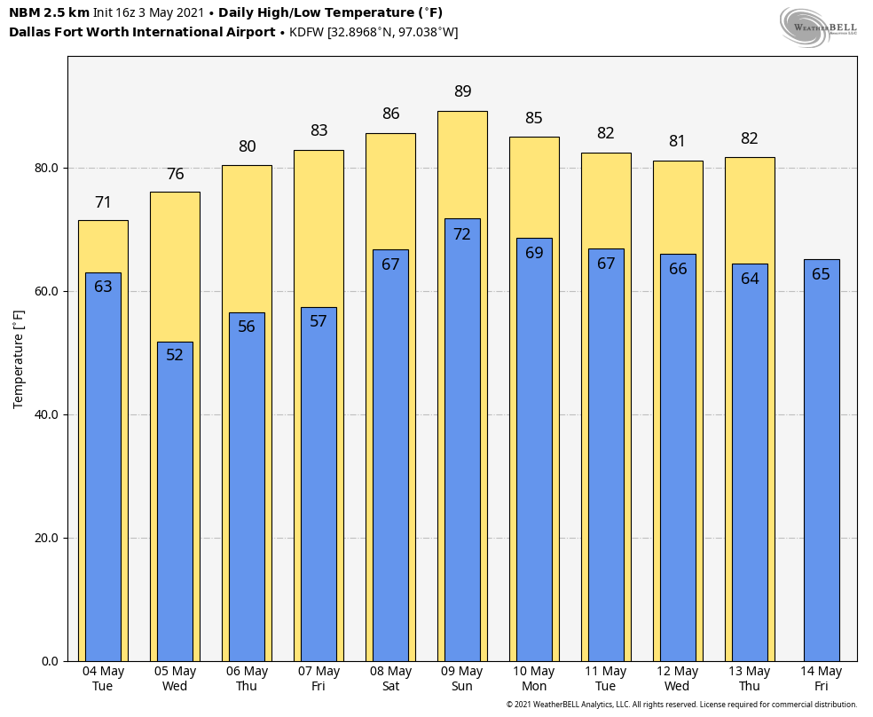 ON THIS DATE IN 1999 - There were 63 tornadoes in Oklahoma, making this the worst outbreak ever to strike the state. In Central Oklahoma alone, eight individual supercell thunderstorms produced 57 tornadoes. Bridge Creek, Moore and southern parts of the Oklahoma City Metro area were hit the hardest. When it was near Moore, Oklahoma, a truck-mounted Doppler radar measured a wind speed of 318 mph, the highest ever observed in a tornado. Forecasters at the Storm Prediction Center in Norman, OK were faced with the unprecedented situation of a major tornado on the ground threatening their location. As a major F5 tornado was approaching the Oklahoma City metro area from the southwest, the SPC notified its backup, the Air Force Weather Agency at Offutt AFB in Omaha, Nebraska that they might have to assume operational responsibility if the tornado approached Norman. The storm remained several miles west of the facility but was visible from the SPC roof. Damage from this single tornado was around one billion dollars, making it the most costly tornado in history.
|
Archives
March 2023
Categories |
 RSS Feed
