
|
Mild Morning - Temperatures in North Texas are currently in the mid to upper 60s this morning, very mild and above seasonal averages for this time of the year. The average low for DFW on February 28 is 44 degrees. If you still haven't guessed it, today will be a pretty mild day with highs in the mid to upper 70s in most spots. I wouldn't be surprised if a location or two touched 80 this afternoon. However, do pack an umbrella as you head out this morning. Rain will return later this morning with a chance of an isolated storm turning marginally severe. The main threat is large hail, but we could see some gusty winds as well. There is a marginal risk for severe storms outlined for some parts of North Texas... 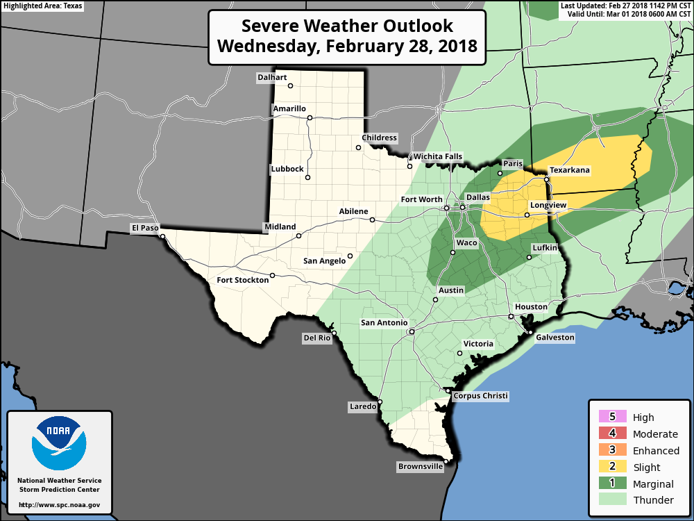 Then during the afternoon hours, storms become more isolated in nature, which means that they could be more intense. Again, the main threat is large hail and damaging winds, but the tornado risk is very low, but not zero. Activity should taper off during the late evening hours and we should be dry during the overnight hours. Rest of the Week - Both days look like perfect starts to March and Meteorological Spring. We will see abundant sunshine on both days with highs in the mid to upper 60s - very comfortable beginning to the new month. Lows on both days will be in the low to mid 40s. We will be down in the low 40s on Friday, and some places could touch the upper 30s, but we don't expect a freeze anywhere. We will remain dry on both days. The Weekend - Saturday is another perfect start with afternoon highs in the upper 60s, with some places touching 70. We will see plentiful sunshine, but we could see a few showers return on Sunday, but that doesn't look like a severe weather risk or a widespread heavy rain event. We should be in the 70s on Saturday. Next Week - After clouds and a few showers clear on Monday, most of next week looks pretty dry with abundant sunshine with highs in the low to mid 60s and lows in the mid 40s. No signs of any terribly hot weather or freezes anytime soon. See the Texas Weather Discussion Video for more details. 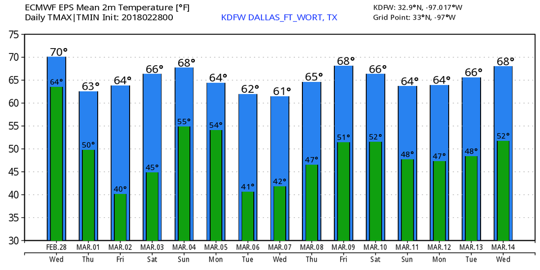 Radar Check - A few rain showers have developed around and just to the west of the DFW Metro, but we expect them to push off to the north, and thunder is not expected this morning.  However, it will remain cloudy, and we do expect to see thunderstorm activity develop during the afternoon. Some of the storms could turn marginally severe, posing a threat for mainly large hail and heavy rain at times during the afternoon hours. We do note that the SPC continues with a 'marginal' risk for severe storms for much of North Texas... 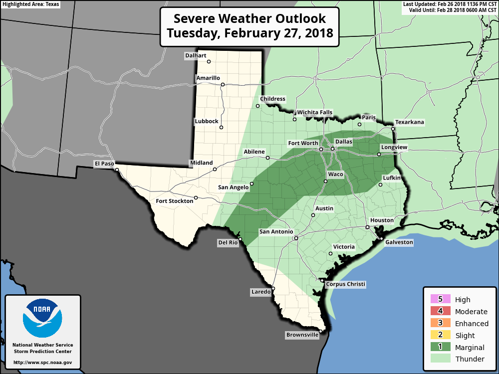 Rain amounts could reach 1/2" in most spots today, but flash flooding should not be a concern. We should see most of the activity taper off during the late evening. Midweek - On Wednesday, we will mention the chance for rain throughout the day. It shouldn't rain all day, but rain at times. Once again, some of the strongest cells could turn severe, especially where the SPC denotes a risk of severe weather once again. 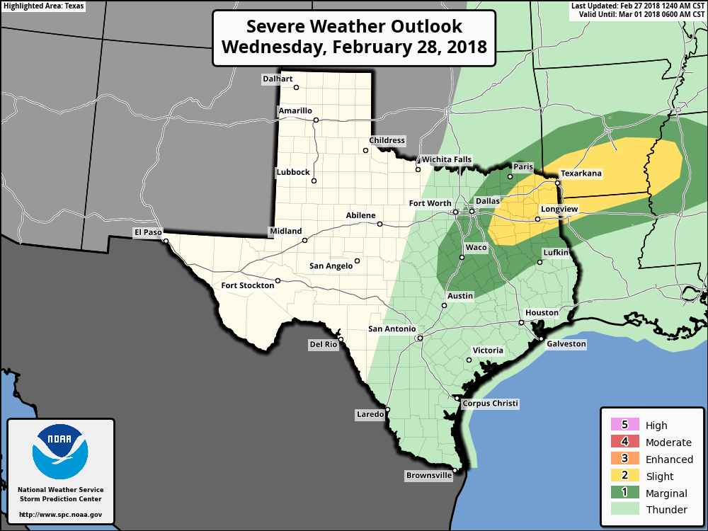 Most of the severe activity won't come until the late evening hours, and even then, the strongest storms should stay to the east. Though we could see some hail-producers creep into North Texas. Highs should be in the low to mid 70s. Then on Thursday, we begin Meteorological Spring and the Spring tornado season. A cold front comes through in dry fashion during the morning hours, but we should warm nicely with highs in the mid 60s. Friday and the Weekend - Friday and Saturday should be dry, pleasant days with lots of sunshine and highs in the mid to upper 60s. Rain could return to the region with another front on Sunday, which would bring the chance for thunderstorms during the afternoon and evening hours. Sunday's high should be in the mid 70s. Next Week - Some rain could return during the latter half of the week, but early next week looks dry with highs in the mid 60s, right at averages for early March. See the Texas Weather Discussion Video for more details. 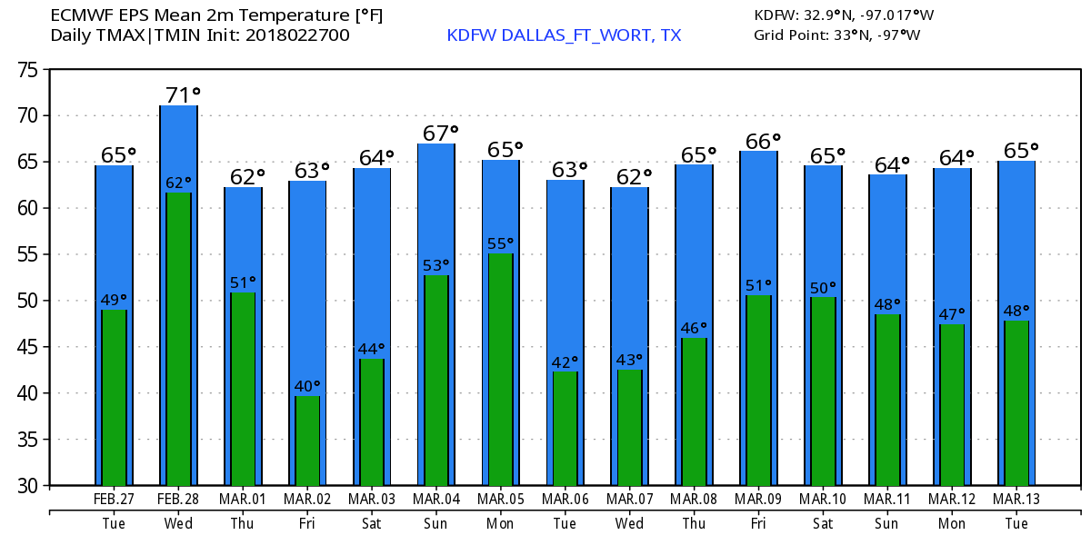 Dry But Foggy Start - A dry start is something that we haven't seen in a while. Temperatures are in the mid 40s across North Texas, but dense fog continue to remain in place this morning. In fact, a dense fog advisory remains in effect until 10AM this morning, where all fog will clear out. Visibility will remain low with 1/4 mile or less. After the fog clears out, we should clear to abundant sunshine during the afternoon hours with highs in the mid 60s. Rain returns to the state tomorrow, mainly during the afternoon and evening hours. A few strong thunderstorms could turn marginally severe, where the SPC has placed much of North Texas under a 'marginal' risk for severe storms. Hail will be the primary concern with the strongest cells. Most of the rain will begin during the late afternoon and evening hours, though we could see a few scattered storms on radar during the late morning hours. Highs will be in the low 60s. Wednesday Through Friday - Wednesday maybe a mostly cloudy day with occasional showers throughout the morning hours. We could see some thunderstorms take place during the afternoon hours. We do note that the SPC has a risk of severe weather defined just to the east of here... with a marginal risk clipping Fort Worth and surrounding areas. 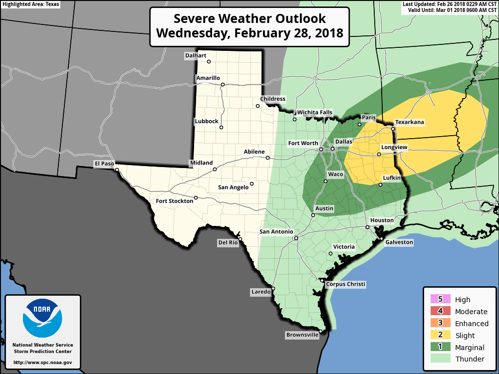 We should be in the mid 70s on Wednesday, then cold air advection from the cold front keeps us in the upper 50s on Thursday. Rain amounts this week should be in the 1/2" - 1" range. We still remain dry on Friday with highs in the mid 60s and sunshine out in full force. The Weekend - After this week, we will enjoy a dry weekend for a change with afternoon highs in the low 70s with morning lows in the mid to upper 40s. Sunshine should be out in full force this weekend. Next Week - We will mention the chance for a few scattered showers returning on Monday. Warm, dry air sticks with us for the rest of the week. See the Texas Weather Discussion Video for more details. 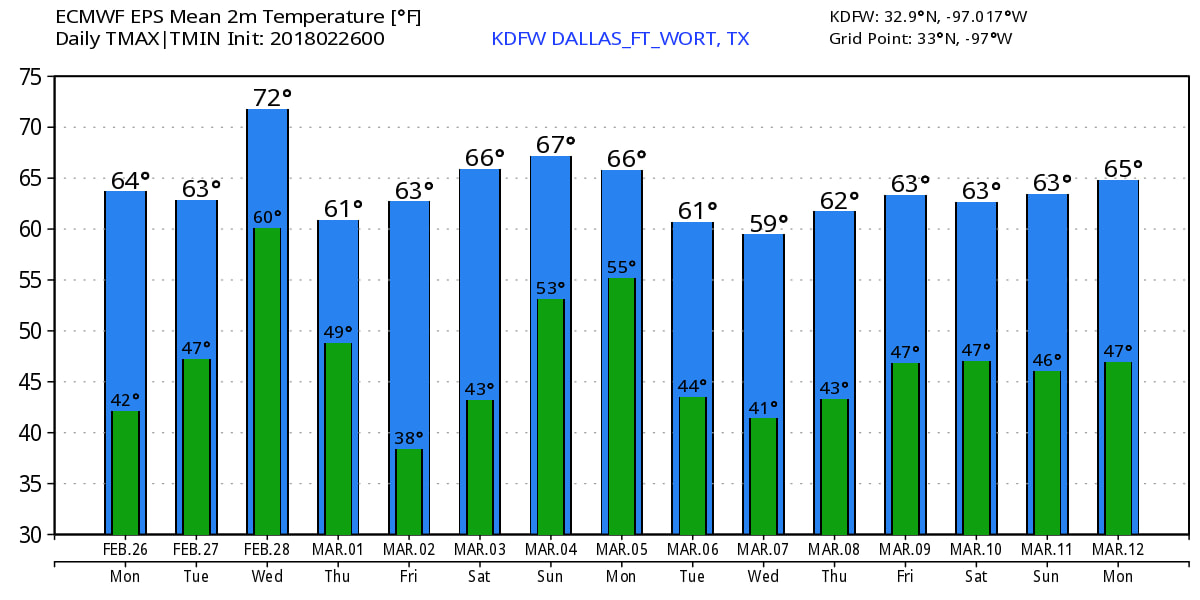 Radar Check - A cluster of thunderstorms continues to move to the north, away from DFW. Most of these are producing lightning, so be sure to exercise caution.  Not as much rain on the radar this morning, but rain will return in the next few hours, with most of the widespread rain to the west of the DFW metroplex. We still could see a few thunderstorms that has the potential to dump heavy rain this afternoon and evening. Highs will be in the mid 50s this afternoon. The Weekend - During the pre-dawn hours on Saturday, rain will mostly be in the form of scattered showers and storms. Then at around 10:00AM, the rain transitions into a cluster of strong to severe storms. These storms will have the potential of producing damaging winds and mainly large hail. The tornado threat is low, but not zero. The tornado threat will be maximized in the Ark-La-Tex region, where there is an Enhanced risk for severe weather issued by the Storm Prediction Center. 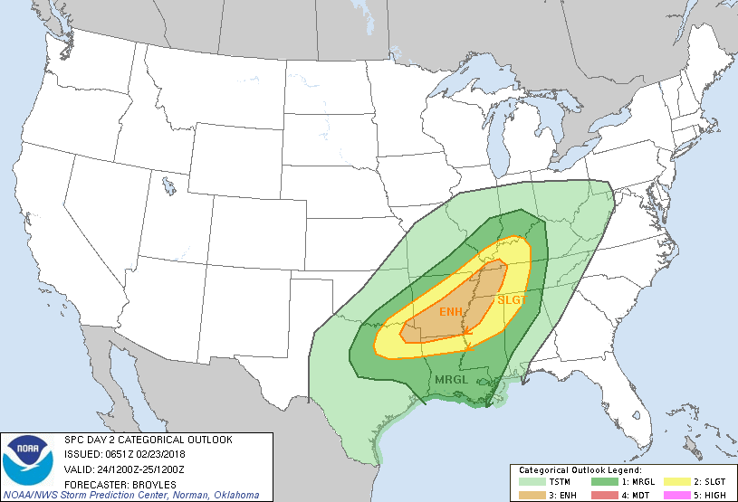 Right now, it seems like the main window for rain and thunderstorms will be from the pre-dawn hours to 2:00PM. Then, the rain transitions into a squall line capable of producing all modes of severe weather within the Enhanced risk area. Any supercell that forms has the potential to rotate and produce tornadoes, a few of which could be strong. More details are in the Texas Weather Discussion Video. The high for DFW on Saturday should be in the low 70s. After the surface front comes through, we trend drier on Sunday with a mix of sun and clouds. The high should be in the mid to upper 60s. Next Week - We stay dry on Monday, but we will need to introduce a chance of a few showers during the latter half of the week. These showers should be scattered in nature, and we don't anticipate a big washout like this week. Highs should be in the mid to upper 60s during the week. 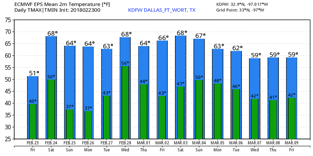 Long Range - Models are still trending towards a negative North Atlantic/Arctic Oscillation as we head into march, which would set up for some cold snaps over parts of the US. Winter is far from over, despite Meteorological Spring beginning March 1. See the Texas Weather Discussion Video for more details.
Radar Check - For the first time in a while, the radar is actually quiet here for much of North Texas. We remain dry this morning. We nearly dodged a bullet for those that are Tarrant and Dallas counties. Had the temperature been two or three degrees cooler yesterday afternoon and evening, roads would have been iced over across much of the metro. For now, we are still in the low to mid 30s this morning, and we should warm to the mid 40s this afternoon. Rain returns to the region during the brunch hours. Counties to the west are still dealing with the threat for freezing rain and sleet, where a Winter Weather Advisory remains in effect until 10AM and 1PM for our western counties, including Denton. Friday - Rain returns to the region tomorrow morning, though the northern half should remain dry during the morning. Rain then overspreads the region during the afternoon hours, where an additional 1/2" should be expected. We should warm substantially with highs in the upper 50s/low 60s. The Weekend - A surface front makes it way to the east during the morning hours, which will bring more chances of showers and storms. They remain scattered at first, becoming more organized during the afternoon hours. Some storms could turn marginally severe, posing the threat for mainly large hail and damaging winds to the east of I-35. This is where the SPC has a slight risk defined for the northeast part of the state. 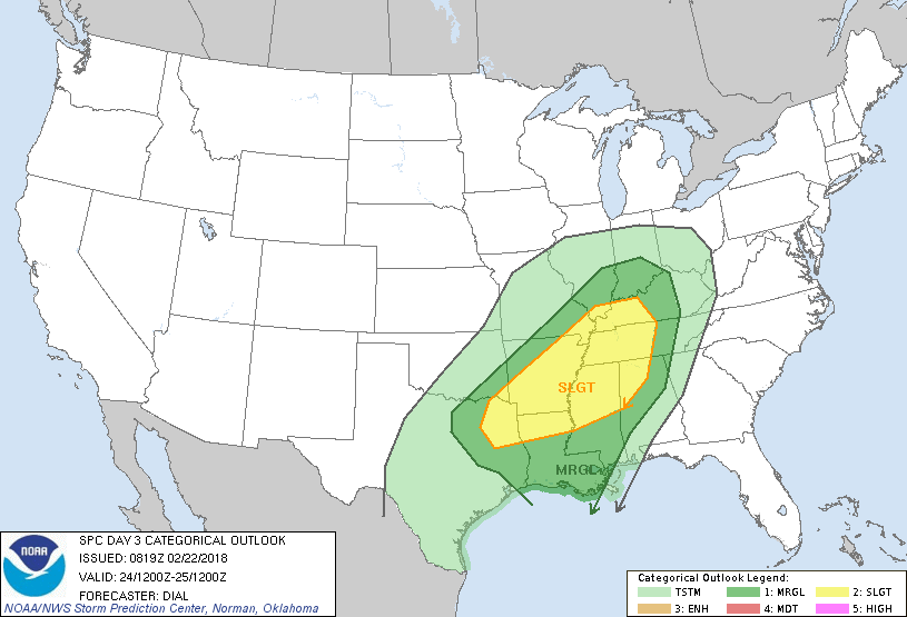 Some storms could be strong while scattered, but there is a good chance that instability won't kick in until the afternoon. Once the surface front pushes through, we should remain dry for the rest of the weekend with a mix of sun and clouds. We should be in the upper 60s on Saturday, and mid 60s on Sunday. Next Week - We remain dry on Monday, then a deep surface low forms over Kansas on Tuesday, which will bring the chance for rain at times on Wednesday as well. The latter half of the week remains dry. The high for most of the week should be in the mid 60s. See the Texas Weather Discussion Video for more details. 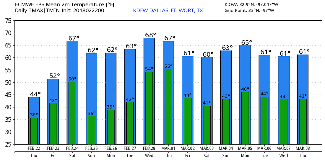 Radar Check - No thunder, but widespread rain continues over the DFW metroplex. Due to below freezing temperatures, some of that rain is turning into freezing rain and sleet, where reports of freezing rain has been made near Weatherford and surrounding areas. 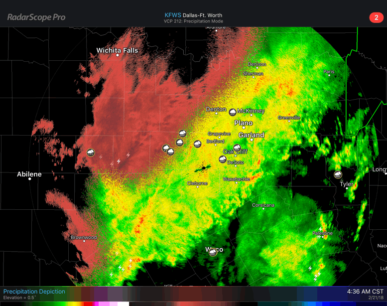 I do think that some of this freezing rain has the potential to leak into Tarrant and Dallas counties later this morning. Plan for another wet commute to work and school this morning, and be especially careful since some roads, bridges, and overpasses may be icy in some spots. Widespread rain continues through the afternoon hours. There will still be the threat of some wintery precipitation, but most of it will be confined to the western parts of North Texas. We should struggle to get out of the 30s today due to cold air advection. Rainfall Totals - Some places in North Texas have already measured over an inch of rain, and it is not even the afternoon yet. We can expect an additional 1-2" this afternoon and evening. The good news is, we do get a break from the rain this evening and tomorrow morning, but some scattered showers can't be ruled out as you head out the door. However, that break won't last long at all, as scattered showers and storms return to the state during the afternoon hours. An additional 1/2-1" of rain can be expected from that. Tomorrows high will be in the low 40s. Friday and Saturday - Some places to the south of the immediate DFW area could have a wet commute starting off, but the north won't stay dry that day. Rain overspreads the north during the late morning/afternoon hours once again, but it shouldn't rain all day. Friday's high will be in the mid 50s. A surface front comes through on Saturday, bringing additional chances for scattered showers and storms, mainly during the morning hours. The front shifts to the east very quickly, and begins to affect the Ark-La-Tex area, where we do note a risk for severe weather has been noted for Saturday for that area. For DFW, once the front passes by, there is a chance we could see some sun peak out during the afternoon. Highs should be in the low 70s. Sunday - For the first time in a while, Sunday should be a completely dry day! Sun will break out with highs in the low 60s. Next Week - The early part of next week remains pretty dry, then scattered showers and storms return during the latter half of the week, but shouldn't a widespread rain event like this week. See the Texas Weather Discussion Video for more details. 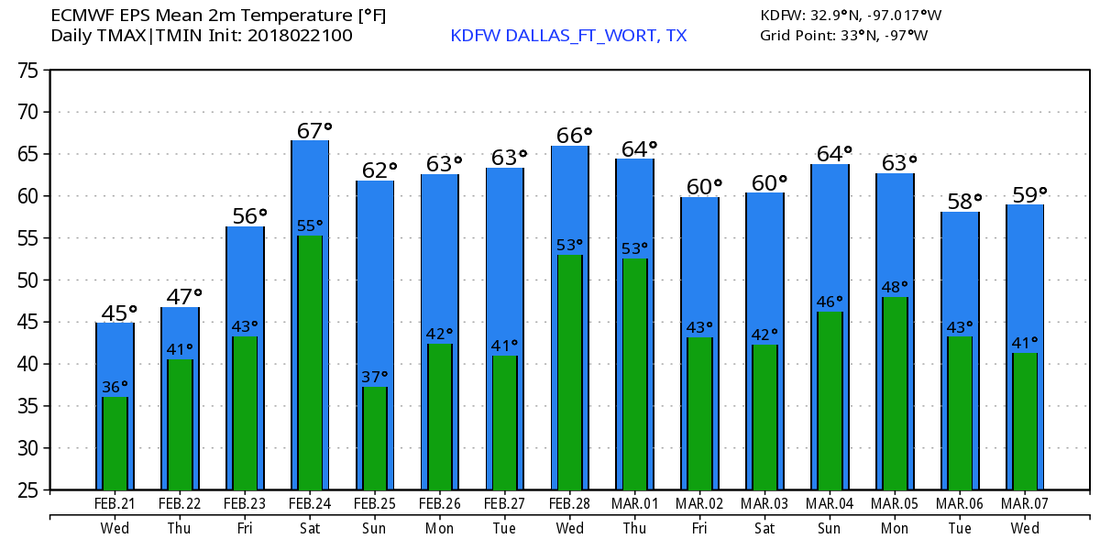  Our Current Look In North Texas at 5:34 PM
We had our very short break from the rain during some of the morning hours, which honestly didn't last long at all. Heavy rain continues to develop and move to the northeast producing very torrential rainfall. Many locations and personal rain gauges across the metro have measured over two inches of rain since this morning, and the rain is not even over yet. In fact, a cold front is moving through the area as we speak, which will cause temperatures to drop drastically this evening. Some places have drop to the mid 40s for the areas on the backside of the front. In fact, some places to the west might even begin seeing freezing rain, and that will be a concern for tomorrow, mainly for the areas to the west of DFW. A flood warning is now in effect for Denton, Tarrant, Collin, and Dallas counties this evening. Some minor flooding will be possible this evening with an additional 1-2 inches this evening. Some thunder is possible, but severe weather is not expected, and flooding will continue to remain the greatest threat. See the other blog posts concerning tomorrow for more details. Radar Check - Heavy rain and thunderstorms continue to move to the northeast this morning...  Scattered showers and thunderstorms will be possible on the back edge of the leading complex, so expect some lightning and a wet commute to work and school this morning. There will be a break in between the rain this morning, then rain becomes widespread again during the afternoon hours, so take that umbrella to use for the rest of the day. The high should be in the mid 70s today with cloudy conditions for most of the day. Flooding may become a concern with the amount of rainfall that we receive. As a result, the Weather Prediction Center has put North Texas under a moderate risk for excessive rainfall/flash flooding. 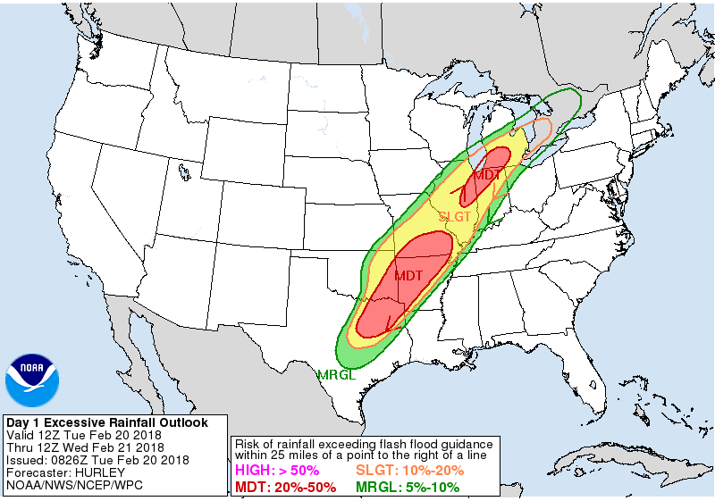 Rain amounts of up to 2" & more is likely within the course of today and tomorrow, with widespread rain possible each day. It won't rain all day, but definitely heavy rain at times. Wednesday at midnight won't be a widespread rain event, but scattered showers and thunderstorms is likely throughout the region. Where the freezing line is with the cold front coming through during the morning, we will introduce the chance for freezing rain, mainly for areas to the west and northwest of DFW. It won't be a widespread event, but will certainly create some icing issues on bridges and overpasses where freezing rain falls. Luckily, the main concern will be heavy rain, with the possibility of flooding in some spots. Highs should only reach the mid 40s on Wednesday. We will have another break in between the rain Thursday morning, then it becomes more widespread during the afternoon hours. It won't rain all the time, but certainly rain at times. We should warm to the low to mid 50s. Rain continues during the day on Friday with highs in the mid 60s. The Weekend - A surface front along with a surface low near Dodge City will bring the chance of heavy rain (and some thunderstorms) during the afternoon/evening hours on Saturday. Then on Sunday, the surface front pushes to the east, and we should be dry for the first time in ten days or so. We will forecast a mix of sun and clouds with highs in the mid 60s. Next Week - The early part of next week looks dry, but rain returns during the latter half of the week from surging moisture from the Gulf, it shouldn't be as torrental as this week's event, but certainly enough to add to the already drought-busting rains. See the Texas Weather Discussion Video for more details.  Mild, Late Winter Afternoon - In fact, it feels more like spring across North Texas this afternoon. Temperatures are in the 70s across the board, with some places touching 80 this afternoon. Clouds are still in place for much of the state, and heavy rain is starting to become the main concern. In fact, a Flood Watch has been issued for most of the North Texas coverage as I am writing this. 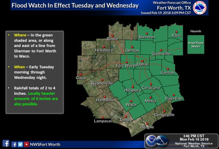 It is quiet now, but that will change after 6 this evening. Any storm that develops ahead of the main complex will have the potential to turn supercellular with potential for damaging winds and large hail. The tornado threat is low, but not zero. We will see most of the rain move through the area overnight into the pre-dawn hours tomorrow, which will make for a very wet commute to work and school. Most places will get 1" to 1.5" of rain during this time frame. High Amplitude Pattern - The high amplitude upper air pattern which features a deep, cold trough in the west and a warm ridge in the east will create flood problems for North Texas and parts of the lower Ohio Valley, where the WPC has outlined a moderate risk for excessive rainfall here in NTX.  Likewise, we have potential for record low and high temperatures for areas in each of the difference air masses. 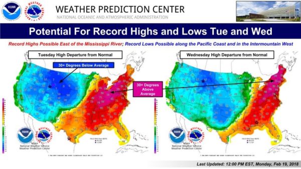 Here in Texas, we will continue to mention rain at times during the day on Tuesday, with widespread rain returning Tuesday night. Wednesday morning might be another wet commute. We should be in the mid to upper 40s on Wednesday, due to a cold front coming through. Luckily, we should be to the east of the freezing line, which will eliminate any chances of us seeing freezing rain for now. Thursday and Friday - Both days will be wet days with rain at time throughout the day. We will continue to forecast multiple rounds of widespread rain as we get closer. Highs should be in the low to mid 50s. Don't expect to see much sunshine this week. The Weekend - A surface front comes through Saturday, which will add more chances of showers and storms during the day. Again, rain at times with highs in the mid 70s. Sunday could actually be our first dry day in quite some time after the pattern loses its shape. If this were to verify, Sunday would be a dry day with mostly cloudy conditions along with afternoon highs in the low 60s. The surface front should push to the west near the lower Ohio Valley, where the SPC notably mentions a risk for severe storms on Saturday for that region. Next Week and Beyond - Next week will be mostly mild with highs in the low 70s. Rain could return during the latter half of the week, but won't be a washout like this week. 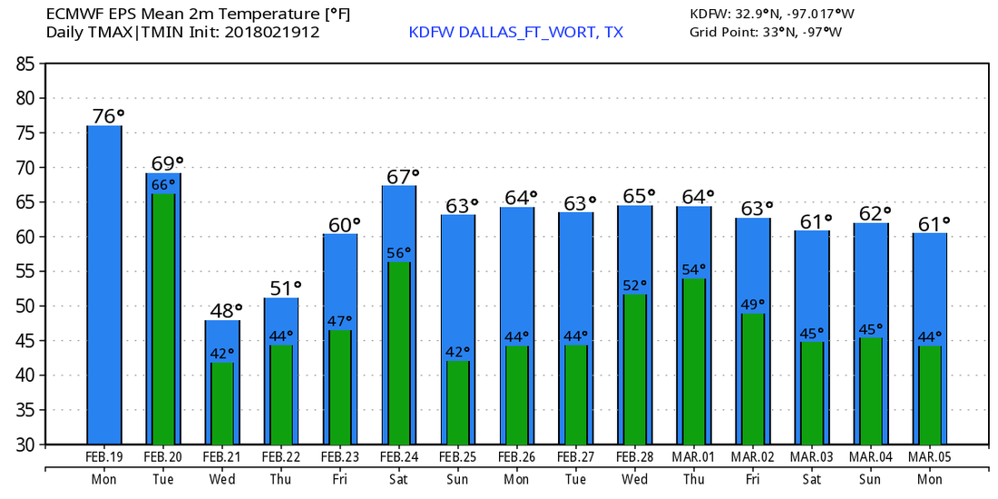 We see no freezing temperature issues for the next 10 days, though global models have been hinting that we could still see cold shots during the middle of March, which then raises the concern of severe weather issues. But, of course, that is to be expected since March is officially the start of the spring tornado season here in the Deep South and the Plains. See the Texas Weather Discussion Video for more details.  Today, we introduce one of our new producers/writers, Jonathan Williams! He will be frequently covering up to date stories of interest as well as updating the weather blog on the weekends! Be sure to follow him on twitter @wx_dfw!
Scattered rain showers have developed in Collin and Dallas Counties and are moving NE. Overall coverage of rain today will be near 60%, with some storms becoming marginally severe. The overall severe risk is NOT high, but it's not zero. A few storms, especially this afternoon and tonight, may produce quarter to half dollar size hail with damaging winds in excess of 65mph. An isolated tornado is also possible. Heavy rain will be a LARGE threat this afternoon and tonight, along with localized flash flooding. By tomorrow, flash flooding will turn from localized to more widespread, especially in those low-lying areas. Remember - Turn around, don't drown. Widespread rain is expected to continue throughout this week with NO winter precipitation, but our far western and northwestern counties may have a small window for freezing rain on Wednesday morning-afternoon with very minor ice accumulations possible. NO winter weather is expected on Wednesday, but highs will struggle to reach 40° during the afternoon. Widespread showers are still likely Thursday and Friday with possibly another severe risk (especially east of Dallas) by next Saturday. Spotty showers possible next Sunday, but I think the majority stay dry.
Have a great day, North Texas! ;) -Jonathan Good Monday Morning, North Texas! Jonathan here! Donovan will likely be making a weather video this afternoon and not this morning, so I will be making a morning blog, and we've got a lot to talk about. TODAY: Today will be one of the most concerning days of this week, with severe weather in the forecast. The Storm Prediction Center has placed DFW in a level 1 marginal risk of severe storms. This may be upgraded to a level 2 slight risk, and possibly a level 3 enhanced risk for many reasons. 1) I was looking through the latest model guidance and it appears that surface based instability may approach 2000 across the DFW area. Earlier, 500 was the forecast on the scale, so indeed a major increase. 2) The capping inversion, which is a layer of warm air in the atmosphere than reduces and prevents severe thunderstorm development and cause elevated thunderstorms, which is what happened in our southwestern counties yesterday morning as that area of rain moved NE, dropping a quick quarter inch across the southern half of the metroplex. This won't be the case today, so we will monitor the threat of significant severe weather. A severe thunderstorm watch may be issued later today, and I can't completely rule out a tornado watch because significant tornado parameters looks fairly impressive this morning from soundings and morning guidance. I'll keep you updated if any watches are posted. It appears that we may have a squall line of strong to severe storms later this evening, as well as discrete supercells this afternoon. The main threats look to be large hail up to golf ball size, some possibly larger, and 60-70mph winds. Isolated tornadoes are also possible, especially across the western and northern half of North Texas. Follow me @wx_dfw on twitter for updates all afternoon, as well as check Donovan's as well. Again, he probably will be posting a weather video this afternoon which will inform us on latest weather forecasts, so make sure to frequently check the website and see if he has posted it. The next several days: Widespread rain and thunderstorms (at least 70% coverage) the next several days, which mainly a flooding and heavy rain threat later this week. Widespread storms are likely all day tomorrow will flooding becoming a possibility, and a strong cold front will aggravate this storm development. This front will knock temperatures down into the 40s for highs on Wednesday will a widespread cold rain. I cannot completely rule out some freezing rain across our far western or northwestern counties, but ice accumulations, if any, will remain minimal. I'll let you know if this changes as the NAM continues to change it's outcome Wednesday afternoon. Widespread rain continues to be likely into Thursday, with another cold front next weekend bringing widespread storms, some severe next Saturday, with the cold front possibly bringing in cooler and much drier air, and it may give us a small break next Sunday before rain may return by next Monday. Anyways, stay up to date with forecasts today as we may have severe storms this afternoon. Your seven day forecast is down below. Have a great day! -Jonathan 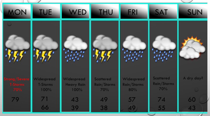 Its been a rainy weekend so far with a few areas seeing .5"-1.5" of rain in the DFW metroplex. These totals will continue to increase through the next 10 days with a fairly wet pattern developing for Texas into the Ohio Valley.
Temperatures: They will remain fairly mild with many days in the 60s & 70s, but Wednesday looks to be a much colder day with highs possibly in the 30s and 40s. We will rebound to near 50° by Thursday, with 60s by next weekend. Any threat of winter weather: This threat is near zero the next 10 days, except for Wednesday. Widespread storms will continue Tuesday Night, but that may transition to freezing rain and sleet, mainly NW of DFW. By afternoon, the NAM and Icon models both have temperatures falling into the mid and lower 30s by late afternoon Wednesday. With a disturbance and abundant moisture bringing widespread precipitation, we will watch for any threat of the rain switching over to freezing rain and sleet. This appears unlikely, but we will continue to monitor this potential in the next 48 hours. Precipitation totals: This is going to be the wettest pattern we've experienced since the summer of 2017. Amounts of 2-4" of rain are expected Tuesday and Wednesday, and a flash flood watch may be needed, but I think the NWS may hold off on doing that at this time due to the recent lack of rainfall. An additional 1-4" of rain looks to fall after that. So the official forecast is 3-8" of rain possible in the next 10 days. Sorry sunshine lovers, the sun looks to be mainly vacant for a while. We may have a brief reprieve in chances of rain next Sunday & Monday, but the European continues to bring a high chance of rain those days, so will leave a 30% chance of rain for now. Enjoy your evening, DFW. By the way, this is a new writer for ApexWxs' website. -Jonathan Williams. This morning - Temperatures have not changed much since yesterday morning; Arlington at 60 while DFW reports a temperature of 67. Don't get too caught up with these warm temps. A cold front will come through this morning, which will cause temperatures to go the wrong way as we progress through the day. Thankfully, it won't turn terribly cold like it has in the past almost every time it happens. We should fall to the low 50s this afternoon. Rain will become possible after 1:00P, with the highest coverage generally in our northern counties. It won't be a downpour, and rain amounts should stay below 1/4ths of an inch. We will see most of our rain come tomorrow morning. Prepare for a wet commute back home from work and school. The Weekend - After some showers pass through the area Friday evening, rain becomes widespread during the pre-dawn hours on Saturday, ending during the afternoon. Though, a few showers may still carry on during the afternoon. In terms of timing, the best chance for rain in North Texas will start before 2AM, then completely drying out by 10-11AM. Rain amounts should be in the 1-1 1/2 inch range, and severe weather should not be an issue. In fact, we probably won't see much thunder from this one either. We trend drier on Sunday, though we still could see a few showers pass by during the morning hours, but the rest of the day stays generally dry. We should be in the mid 60s by Sunday, and clouds will still stick to us throughout the day. Next Week and Beyond - We won't see much sun next week as the upper air pattern persists. Trough in the northwest, ridging in the Gulf of Mexico will create a broad southwest flow aloft, which will allow some rain chances almost everyday. 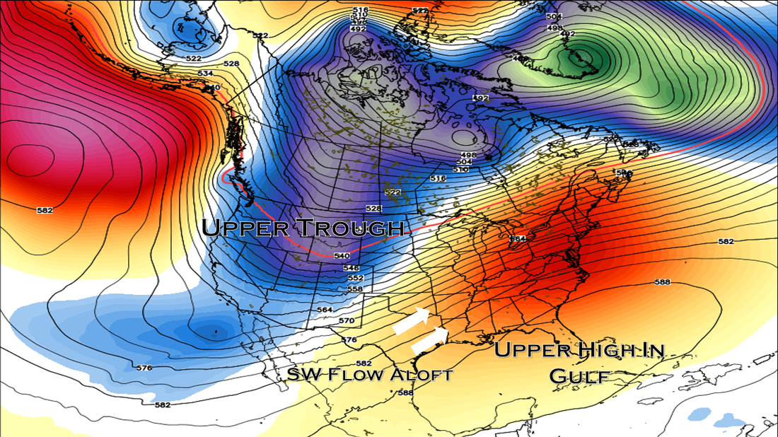 Temperatures will be in the 60s for the latter half of the week.  A Word of Advice - Winter is far from over, and cold snaps can still happen in March and April. The European Ensemble model shows one in mid March. See the Texas Weather Discussion Video for more details.  Mild Start - Mild start is something we haven't said in quite some time... Temperatures are in the mid to upper 60s around the region this morning, and we will get warmer as we head throughout the day. With a mix of sun and clouds, temperatures should be in the low 80s today, with some places maybe reaching record temperatures. The record high for February 15 in Dallas is 83, set in 2005. Temperatures fall during the day tomorrow, and we should be in the low to mid 40s by the evening hours due to cold air advection. We will most likely reach our high temperature in the morning hours. We will also introduce a chance of showers, mainly during the morning hours. It should be a mostly cloudy pay. The Weekend - Moisture surges from the north, and we will continue with a chance of widespread showers and storms during the day on Saturday in wake of a cold front. This will bring beneficial rains to state during the weekend. No way of telling exact start/stop times, but prepare for a very wet and muggy day on Saturday. Rain amounts will be in the 1-1 1/2 inch range in most spots. We only reach the low 50s Saturday. We trend drier on Sunday, but we could see moisture from the south, and we will mention another chance of showers during the day. Rain amounts should stay fairly light, and we should warm to the low 60s. No severe weather is expected. Next Week - The overall upper air pattern remains the same; Troughing in the western U.S, ridging in the Gulf of Mexico. We will mention the chance of some rain everyday next week. Strong to severe storms become possible on Monday as a corridor of instability develops, but keep in mind that Monday is four days out and a lot of things can change. Highs should be in the 50-60s. See the Texas Weather Discussion Video for more details.  This morning - Temperatures are warmer this morning, with most places in the 40s. Abilene in West Texas reports a temperature of 54. We don't see much on the radar this morning, but expect some patchy drizzle and fog as you head out the door. We will reach the low 70s by the afternoon, with some places touching 75 with a cloudy sky. We remain mostly dry today. Don't count on any rain tomorrow though. Highs will be in the upper 70s with lows in the low 60s with a mix of sun and clouds. Some places will touch 80 degrees by the afternoon. The record high for February 15 in Dallas is 63. Friday and the Weekend - A broad southwest flow pattern will persist over much of the southern US, which means that we will see very little, if any, sun over the next few days. A cold front will come through here late Friday and Saturday, stalling out somewhere in North Texas. We will continue with a chance of widespread rain on Saturday with the stalled front in place. It won't rain all day, but it will for a good chunk of the day. Rain amounts should stay in the 1-1.5 inch range. Highs should be in within the 50 degree range. Next Week and Beyond - This upper air pattern will continue to persist, which means, most days will be mostly cloudy with at least some chance for occasional showers. Highs will be average for late February; mid 60s. Thankfully, no severe weather is expected from this pattern, and will only most likely produce beneficial rains for North Texas and the Ohio Valley. See the Texas Weather Discussion Video for more details.  Chilly Start - Temperatures are in the upper 30s to low 40s across the board in north Texas, which is a classic February morning in North Texas. We will not warm that much today, with some places warming ten degrees at best. Today will be a mostly cloudy day with a broad southwest flow aloft, and scattered showers will be possible throughout the day beginning after 10AM. It is one of those cases where it is nearly impossible to predict exact start/stop times, but prepare for rain at any time during the day. Rain amounts should stay below 0.3ths of an inch today. We will only climb to the low 50s for highs. Tomorrow/Thursday - Clouds will remain in place with a broad southwest flow, but some rain will remain possible during the early morning hours. Highs will climb to the upper 60s tomorrow, with some touching 70. Then, on Thursday, we get much drier air, and temperatures will climb to the upper 70s, with some touching 80s in the urban areas. The record high for February 15 is 83, set in 2005. Friday and the Weekend - A cold front pushes from the south, which will make for scattered to numerous showers and storms, mainly during the late afternoon and evening hours. I do think most of the winter weather will stay to the north of us, and we will only see rain at that time. And the rain continues into Saturday, where widespread rain is possible during this time, something we have been wanting for over three months or so. Highs will be in the low 50s for Friday and Saturday. Then, on Sunday, we trend much drier with clouds clearing up, although we still could see a few showers during the morning hours. Highs should be in the low 60s as we warm up. Next Week and Beyond - Monday will just be a mostly cloudy day before some rain chances return during the rest of next week. If you've been catching the trend, it seems like rain will be possible almost everyday after this Thursday. Thankfully, the upper air pattern will keep the really cold air bottled to the north, which will make this week generally average. No signs of any terribly cold arctic blasts, snow, or wintery precipitation for the rest of February. See the Texas Weather Discussion Video for more details. 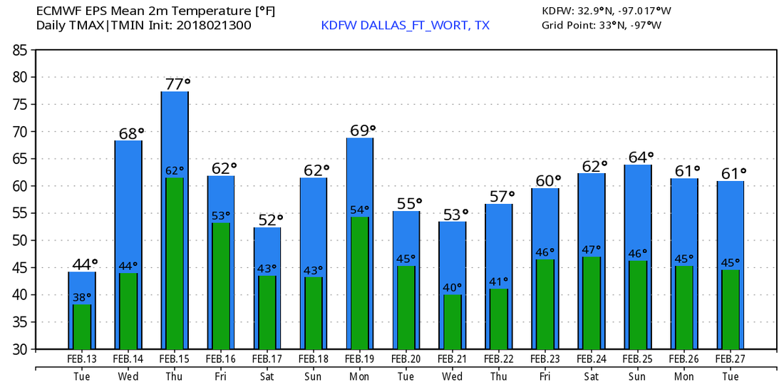 Freezing Start - Temperatures are in the mid to upper 20s across the board this morning, with some of the urban places touching the low 30s; a classic February morning. Most of the ice on the roads from yesterday's winter event has already melted, so most of the roads will be fine. We will warm to the mid 40s today with sunshine out in full force. Look for a very similar day tomorrow with highs in the low 50s. However, a few showers will be possible during the evening hours as moisture begins to increase. The rest of the day should be mostly sunny. Wednesday through Friday - Wednesday should feature a rainy morning but pleasant day with highs in the low 60s, after starting the morning off in the upper 40s. Thursday will be a very dry day with afternoon highs in the mid to upper 70s, with some places touching 80, some even flirting with record highs. A cold front comes through Friday morning, which will cause afternoon highs to stick in the upper 40s. Rain will also be possible in advance of that front, but it remains known whether or not we see winter weather return during the afternoon. The Weekend - After seeing a few showers go through Saturday morning, look for mostly dry conditions with highs in the mid to upper 50s and lows in the 40s. Most of the weekend will be dry. Next Week and Beyond - The very beginning of the week looks dry with highs touching the mid 60s, then rain will return mostly during the latter half of the week, but too early to pinpoint any specific start/stop times. Notice how I've said 'rain' more than usual in this post, that's because we will have chances of rain this week, and even more chances next week. In fact, the CPC (Climate Prediction Center), shows that we will see more precipitation than average through the six to ten day period, which will definitely help with some of the drought problems. See the Texas Weather Discussion Video for more details.   Chilly Start - Temperatures are in the upper 40s to low 50s across the board this morning, which is usually a good sign of a mild day ahead. Afternoon highs will be in the upper 60s today, with some places touching the 70s. Partly cloudy skies are likely. The Weekend - For Saturday, we will likely reach our high temperature in the morning hours, with temperatures in the mid to upper 50s. From there, as the cold front approaches, temperatures will go the wrong way throughout the day, falling to the mid 30s by the late evening hours. Some drizzle or showers will be possible throughout the day, but there's no way to predict exact start/stop times. However, once we reach below freezing, we will start to see that rain transition to freezing rain Saturday evening. Timing - I am basing this forecast off of the North American Model (NAM), which has been doing a great job of seeing shallow, cold air masses when other models do not. I do think showers will be possible at any time on Saturday, which is something we can't pinpoint a start/stop time, just plan ahead if you have any outdoor activities. Then, as the freezing line reaches our area (8 or 9pm), we will start to see some freezing rain develop to the west of DFW, before becoming widespread by midnight.We could still see some patchy showers throughout the morning hours on Sunday, with possibility for some freezing drizzle to work its way in. Impact - No, I do not expect this to be a winter wonderland, but I do think some icy conditions on roadways will be possible starting Saturday evening. I don't think we will see rapid improvements on Sunday as temperatures will stay in the 30s for most of the day. I would not cancel my plans for the weekend, but do plan for it to rain off and on Saturday and freezing rain Saturday night into Sunday morning. Next Week - The early part of next week looks dry, though we could have some rain return to the state during the latter half of the week. We will need that as the drought gets progressively worse, but that's another topic for another day. See the Texas Weather Discussion Video for more details.  Raw, Cold Morning - It's another cold mid-winter morning in North Texas, where temperatures range from the mid to upper 20s to the low 30s. Thankfully, we should turn warmer this afternoon, with highs in the upper 50s with sunshine in full force throughout the day. Tomorrow will be very mild; we start the day in the low 40s, then we end up in the upper 60s with some communities touching 70. Cold, Wet Weekend - This weekend will feature cold temperatures, with a chance of some wintery precipitation. Saturday will be a mostly cloudy day, we start the morning in the mid 50s, but due to a cold front, temperatures will go the wrong way throughout the day, ending up in the mid to low 30s during the evening. Moisture will also return to the region, and we will have to continue with a chance of a few showers throughout the day on Saturday. There will be breaks in between, and it shouldn't rain all day. If you have any outdoor activities planned, be aware that it could rain off and on Saturday. Then, as the freezing line moves through during the late evening hours, rain will become more likely with the chance of some of that rain turning into a freezing rain/light snow mix. This will lead to icy roads where snow/freezing rain falls, as temperatures will remain below freezing for much of the evening and Sunday afternoon. The initial complex moves through North Texas during the overnight hours, then a second complex of freezing rain will move into the area Sunday afternoon (Sunday morning should be mostly dry). I do think some, but not all, of the ice will start to melt if temperatures reach the mid 40s on Sunday. The bottom line is, prepare for a cold, slushy weekend. Next Week - The early part of next week looks dry with highs climbing to the upper 50s to low 60s, then rain could return during the latter half of the week. See the Texas Weather Discussion Video for more details.  Freezing Start - It is freezing just about everywhere in North Texas this morning with temperatures in the low 30s. This is brings the concern of some lingering ice patches that may could some slick spots on roads, bridges, and overpasses this morning. You do want to take it slow this morning. However, with afternoon highs in the mid 40s and a mostly sunny sky, any lingering ice will start to melt after 10AM this morning. Tomorrow and Friday - Sunshine fully returns tomorrow, and after another freezing start, we should have highs in the upper 50s. Friday will feature a mix of sun and clouds with a high in the mid 60s. The Weekend - Clouds will start to thicken Friday night, and with that, we will have to mention the chance of a few occasional off and on showers during the weekend. For now, we are not able to tell you when the rain will exactly start and stop, but if you have any outdoor plans this weekend, plan for it to rain at anytime during the day. It will remain comfortable on Saturday, with afternoon highs in the upper 50s, some touching 60 degrees during the evening. A cold front drops by on Sunday, and we should only reach the mid 40s for highs. Next Week - Moisture will continue to linger, which means we will have to introduce a chance of at least showers for most of the week. And, temperatures will remain average for February, with highs in the upper 50s. See the Texas Weather Discussion Video for more details. 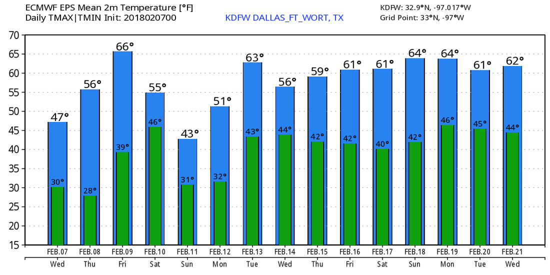 Cold Start - Temperatures are in the mid to upper 30s across North Texas, warmer than yesterday, where we were in the 20s. Due to cold air advection from a cold front pushing through this morning, most of us should struggle to get out of the 30s today, so you might want to grab a jacket and an umbrella as you head out. The sky will be mostly cloudy today. Today, rain is expected for all of north Texas this afternoon and evening. Thunderstorms is likely this evening, with a few turning marginally severe producing severe hail at times. This is where the SPC has introduced a 'marginal' risk for severe storms for areas generally to the south of DFW... 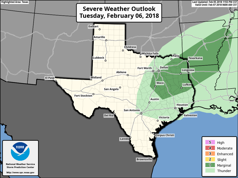 Later in the evening, some of the rain could turn into a freezing rain/light sleet mix as the preexisting freezing rain pushes to the southwest. However, freezing rain is most likely for areas to the north and west of DFW, where a Winter Weather Advisory has been issued...  Just know that I would not be surprised if the Winter Weather Advisory expands to include Parker and Palo Pinto counties, and areas to the south. Timing - From noon to 2PM, showers will be possible to the southeast, with freezing rain likely falling in the Wichita Falls area. From 2P to 4P, rain starts to become more widespread as the main front pushes to the north. And from 4P to 10P, this is where rain is most likely going to be widespread over most of North Texas. Freezing rain will also be a possibility as well, and could start impacting DFW at around 6P or later IF freezing rain makes it to DFW. Impact - Though no flooding issues is expected from this system, freezing rain remains very possible this evening and tonight. If freezing rain falls, light ice accumulations will be possible on mostly bridges and overpasses, which may lead to hazardous travel in some spots. Additionally, severe hail will be possible from a few marginally severe storms, which may lead to minimal hail damage where it falls. So the bottom line is, don't worry about a big hail storm or major ice problems, just be prepared in case freezing rain makes it to DFW. Rest of the Week - Sun will start to peak by Wednesday, with mostly sunny conditions on Thursday. We will warm up after today, with highs in the mid 60s by Friday. Weekend - Our next chance of rain will start Saturday morning with mostly cloudy conditions. Highs will be in the low 60s on Saturday, with a cold front coming through on Sunday, dropping the high to the mid 40s the next day. Next Week - Seems like our next rain chance will start right on Monday with a few showers, then rain appears possible for most of next week. It will be a muggy week if this verifies. See the Texas Weather Discussion Video for more details. 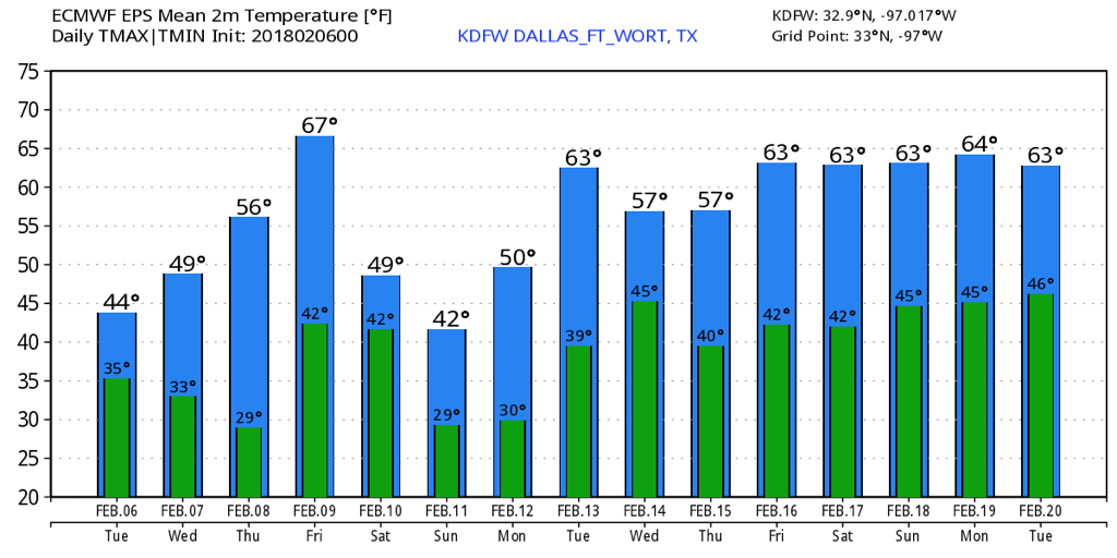 Cold Start - Temperatures in North Texas are in the 20s across the board, with cooler temperatures to the north. A frost has likely developed in most places in NTX. Clouds will stick to us today, and highs will only be in the low 50s due to cold air advection from the cold front that came through during the day yesterday. Tuesday - Tomorrow will be mostly cloudy to start off, drizzle will be possible during the morning, before transitioning to widespread showers during the afternoon. It is worth noting that freezing rain will be possible for our northern counties, but should not reach DFW. Rain becomes more widespread as we go through the evening. Thunderstorms will also become possible during the evening, with a chance of some of them turning marginally severe with .75" hail possible. Rain amounts should stay below 1/2 inch for most places, and afternoon highs will be in the low 50s. Rain will continue overnight. Wednesday Through Friday - A few lingering showers will be possible during the morning hours on Wednesday, then we turn drier with highs in the low 50s. We will warm up through Friday with mostly sunny skies and with the high possibly reaching 70 by Friday. The Weekend - Our next chance of rain will lie Saturday morning with another surface front pushing through. Rain amounts will generally stay fairly light with highs in the low 60s. With mostly cloudy conditions, we cool down on Sunday, with highs dropping to the low 50s. Next Week - Monday looks generally dry. We could see another chance of showers and storms by Tuesday with a surface front moving through. This would be a rain mass that would affect main states to the north, in addition. Too early to tell specific rain amounts and timing of the system, but just an idea that both global models agree on. See the Texas Weather Discussion Video for more details. 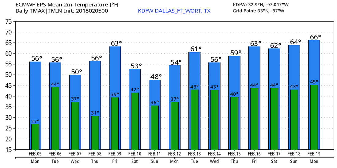 Welcome to February and Groundhog Day - The average high for DFW raises from 58 today to 65 degrees on February 28. The warmest February temperature on record is February 21 & 22, 1996 when the high reached 95 degrees. The coldest temperature came on February 1 & 2, 1951 with a low of 7. No sub-zero temperatures are recorded for DFW for this month at this present time. This morning is a little chilly, today will be cooler than yesterday with highs in the mid 50s with a mix of sun and clouds. The Weekend - Saturday and Sunday will be an absolutely perfect day for any outdoor activities. We start the day in the low 40s, then we warm to the mid 60s for both days. Absolutely perfect weather for any outdoor recreation. No signs of precipitation of any kind this weekend. Next Week - Monday will be a similar day to the weekend with chances for showers and storms on Tuesday. It remains known if we see severe weather from this system, but the rest of the week looks very pleasant with abundant sunshine and comfortable temperatures. And no signs of any winter mischief for the next 7-10 days at this present time. See the Texas Weather Discussion Video for more details.  Cool Morning - Temperatures are mostly in the 50s this morning, though Denton records a temperature of 43. With a nice February sun, we should warm to the mid 60s today. The average high for DFW on February 1 is 58. Tomorrow, a cold front will come through in dry fashion, which should keep us on track for the rest of early February. We start the day in the mid 30s, then end up in the low 50s with a sunny sky. The Weekend - Not much change. We will continue to forecast sunny conditions with highs in the low 60s and lows in the upper 30s. No signs of any winter precipitation within the next few days. Next Week - We stay dry on Monday with highs in the low 60s, then a cold front comes through Tuesday, which could set off a few showers and storms. Too early to know specifics, but global models have been persistent in this idea. The rest of the week looks dry with highs in the low 60s. No sign of significant winter weather for the next 15 days...  And no sign of any arctic air for the next 15 days. We should stay very average for February. See the Texas Weather Discussion Video for more details.  |
Archives
April 2024
Categories |
 RSS Feed