
|
Radar Check - Heavy rain and thunderstorms continue to move to the northeast this morning...  Scattered showers and thunderstorms will be possible on the back edge of the leading complex, so expect some lightning and a wet commute to work and school this morning. There will be a break in between the rain this morning, then rain becomes widespread again during the afternoon hours, so take that umbrella to use for the rest of the day. The high should be in the mid 70s today with cloudy conditions for most of the day. Flooding may become a concern with the amount of rainfall that we receive. As a result, the Weather Prediction Center has put North Texas under a moderate risk for excessive rainfall/flash flooding. 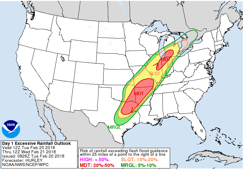 Rain amounts of up to 2" & more is likely within the course of today and tomorrow, with widespread rain possible each day. It won't rain all day, but definitely heavy rain at times. Wednesday at midnight won't be a widespread rain event, but scattered showers and thunderstorms is likely throughout the region. Where the freezing line is with the cold front coming through during the morning, we will introduce the chance for freezing rain, mainly for areas to the west and northwest of DFW. It won't be a widespread event, but will certainly create some icing issues on bridges and overpasses where freezing rain falls. Luckily, the main concern will be heavy rain, with the possibility of flooding in some spots. Highs should only reach the mid 40s on Wednesday. We will have another break in between the rain Thursday morning, then it becomes more widespread during the afternoon hours. It won't rain all the time, but certainly rain at times. We should warm to the low to mid 50s. Rain continues during the day on Friday with highs in the mid 60s. The Weekend - A surface front along with a surface low near Dodge City will bring the chance of heavy rain (and some thunderstorms) during the afternoon/evening hours on Saturday. Then on Sunday, the surface front pushes to the east, and we should be dry for the first time in ten days or so. We will forecast a mix of sun and clouds with highs in the mid 60s. Next Week - The early part of next week looks dry, but rain returns during the latter half of the week from surging moisture from the Gulf, it shouldn't be as torrental as this week's event, but certainly enough to add to the already drought-busting rains. See the Texas Weather Discussion Video for more details.  |
Archives
March 2023
Categories |
 RSS Feed
