
|
Radar Check - A cluster of thunderstorms continues to move to the north, away from DFW. Most of these are producing lightning, so be sure to exercise caution.  Not as much rain on the radar this morning, but rain will return in the next few hours, with most of the widespread rain to the west of the DFW metroplex. We still could see a few thunderstorms that has the potential to dump heavy rain this afternoon and evening. Highs will be in the mid 50s this afternoon. The Weekend - During the pre-dawn hours on Saturday, rain will mostly be in the form of scattered showers and storms. Then at around 10:00AM, the rain transitions into a cluster of strong to severe storms. These storms will have the potential of producing damaging winds and mainly large hail. The tornado threat is low, but not zero. The tornado threat will be maximized in the Ark-La-Tex region, where there is an Enhanced risk for severe weather issued by the Storm Prediction Center.  Right now, it seems like the main window for rain and thunderstorms will be from the pre-dawn hours to 2:00PM. Then, the rain transitions into a squall line capable of producing all modes of severe weather within the Enhanced risk area. Any supercell that forms has the potential to rotate and produce tornadoes, a few of which could be strong. More details are in the Texas Weather Discussion Video. The high for DFW on Saturday should be in the low 70s. After the surface front comes through, we trend drier on Sunday with a mix of sun and clouds. The high should be in the mid to upper 60s. Next Week - We stay dry on Monday, but we will need to introduce a chance of a few showers during the latter half of the week. These showers should be scattered in nature, and we don't anticipate a big washout like this week. Highs should be in the mid to upper 60s during the week. 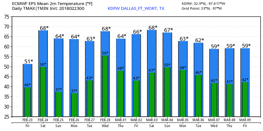 Long Range - Models are still trending towards a negative North Atlantic/Arctic Oscillation as we head into march, which would set up for some cold snaps over parts of the US. Winter is far from over, despite Meteorological Spring beginning March 1. See the Texas Weather Discussion Video for more details.
|
Archives
March 2023
Categories |
 RSS Feed
