
|
Hello ApexStorm readers! I’m here with another weekend update where I’ll detail the upcoming week and what weather North Texas is set to experience! There’s not too much to discuss as it’s a relatively mild week ahead of us, so it’ll be a shorter blog today.
EARLY WEEK: Monday will be a slightly cool day with temperatures likely not making it out of the 50s. Sunshine will be at a premium with scarce cirrus clouds possible from time to time. After an extremely windy weekend, wind will start to subside with gusts only reaching about 20 mph. A small chance for hazy skies due to drought-induced dust from West Texas will still be possible but it will likely be less prevalent or intense as it was over the weekend. A freeze is possible overnight for the Red River counties, but most of North Texas won’t dip below freezing the entire week, unless a temperature bust occurs of course. These are often unpredictable but I see no reason that should occur. Tuesday will be seasonal February temperatures in the upper 50s and low 60s with clouds lingering in the morning. Wind will also be lighter this day. MIDWEEK: Some seasonably warm temperatures will be present Wednesday and Thursday as temperatures climb into the high 60s both days and potentially low 70s on Thursday. Some stronger southerly winds are possible both days as a surface level low approaches our area. Thursday will also be a slightly more humid day with more clouds as a result of the low. LATE WEEK COLD FRONT: Attached to the surface level low will be a cold front that moves in sometime late Thursday with a high level of uncertainty regarding the potential for precipitation. I’m guessing a low level of precipitation at this point with coverage of around 30%. The air mass behind the front is much colder and drier and will keep temperatures much cooler for the weekend. There is also pretty strong model guidance for an artic blast occurring over the weekend and into the following week that will bring much colder temperatures and the potential for winter weather a week from tomorrow. However, it’s extremely low confidence and will definitely require another blog update in the future. For now, stay safe, stay cool, and stay weather aware! -Colin Welty Hello ApexStorm followers! I’m here with another blog update specifically focused on the upcoming winter storm for NTX. I’ll construct this blog a little differently than I normally do but even as we are less than 24 hours out, we’re still dealing with many uncertainties. And yes, I said snow. I’m pretty confident now that DFW will end this snow drought. WHAT WE KNOW: An upper level low is currently sitting over Colorado and is forecasted to move over Texas, starting tonight in the panhandle and moving through Texas until Sunday night. Associated with the upper level low will be a larger amount of QPF (precipitation) than normal due to higher gulf moisture and seasonably cool temperatures. The blocking pattern and upper level dynamics match up nicely to previous major snowstorms in DFW’s history, reminiscing the famous February 2010 snowstorm where parts of the area got a foot of snow. These upper level dynamics are extremely complex and result in a high potential for variability due to the possibility of snow banding and heavy rates of snow, in addition to thermal cooling from high precipitation rates. We also know that areas south and west of here, in places such as Abeliene, Lubbock, and Waco, will receive measurable snowfall. While it’s extremely likely that DFW will receive a dusting, we can certainly say the aforementioned regions will get snow. The track of this low will vary but there is enough guidance from the models showing snow that there will likely be some high totals across Central Texas. WHAT WE DON’T KNOW: The track of the ULL can still change. Models have somewhat come to a consensus that the low will travel across Central Texas, but it could still change by upwards of 50 miles. This track, if more southern, would likely leave DFW with only a dusting. If it went more northern, however, we could be seeing a multi inch storm. It’s extremely complex and we likely won’t know the track of the low until mere hours before. In addition, this setup is conducive for heavy banding of snow. These bands of snow are highly erratic and difficult to predict. While we’re pretty certain on where the higher snow amounts will be, localized heavy bands are likely across all parts of Texas. These localized bands could drop up to 4 inches of snow regardless of where they pass and cool temperatures, which means that anyone who gets a band over them will have higher snowfall amounts than areas around them. The timing of the changeover will also influence amounts. Global models are calling for the switchover to occur after noon, while high resolution models are calling for the switchover before noon. QPF will maintain regardless of what precipitation type it is, so the earlier the changeover, the higher the amounts. 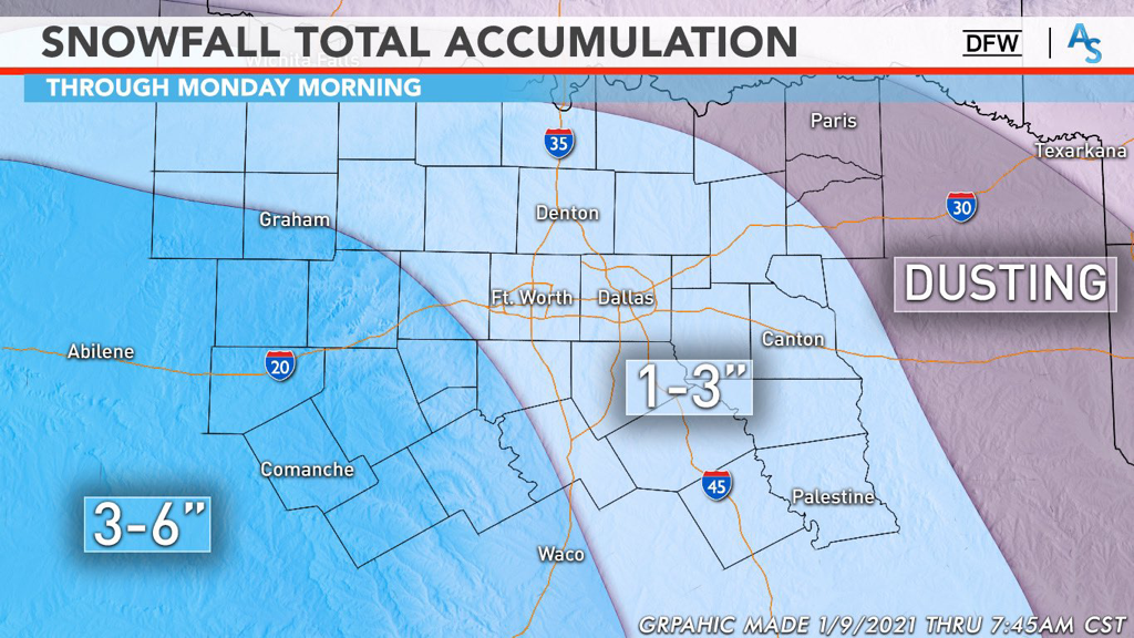 WHAT WE ARE PREDICTING:
The Red River down to the edge of the metro area will likely only see up to an inch, if even a dusting. We’re calling for the bulk of the DFW metro to see between 1 and 3 inches of snow with the potential for higher amounts with localized banding. Areas south and southwest of DFW will see between 3 and 6 inches of snow with localized heavier amounts possible as well. This forecast lines up with most of the professional meteorologist’s opinions as well, such as the legendary Steve McCauley, who is calling for 1-3 inches for DFW as well. This forecast is just that—a forecast. It is SUBJECT TO CHANGE right until the event and we have moved into nowcasting. Pay attention to radars and local meteorologists as this has the potential to be a massive bust or a massive over-performing system. For now, stay warm, stay alert, and stay weather aware! -Colin Welty  Hello everyone! I hope everyone has been paying attention to some of the chatter around the weather community lately because there is an extremely exciting potential for some wintry weather this weekend. I’ll talk briefly about the end of this week but I’m also going to be focusing a lot on what could happen this weekend and what to look out for. I also want to let everyone know that very soon, I’ll be putting out updates for OKC and Southern Oklahoma as part of our expansion for ApexStorm! I’m really excited for that opportunity and we’re finalizing a few things before we get everything started.
END OF THE WEEK: The persistence of a fairly gloomy pattern will result in relatively cool temperatures today with most of the region failing to get out of the 40s. There’s a minimal chance of some spotty showers here and there but it will likely be a cold, overcast day for much of North Texas. Temperatures will largely remain the same for Friday with DFW barely reaching the 50s, seeking up for a likely freeze taking place overnight into Saturday. The clouds will break at some point on Friday, giving way to pockets of sunshine to break up the otherwise dull, gray clouds. Saturday will be really similar to Friday as well, but as it transitions into the night, it gets a lot more interesting. DOES DFW BREAK THE DROUGHT: Wintry weather is a fickle part of weather around here. Some years it’s easy to get multiple events. Other years are more of the snowless status quo. This winter has, so far, been a continuation of the last 5 years. DFW hasn’t seen any snowfall greater than an inch since March of 2015, making it the 3rd longest drought in recorded history. It’s been difficult, time after time, seeing what looks to be a promising signal of winter weather, only to be left with flurries at best or cold rain at worst. However, this weekend could be the end of that drought. A classic bowling ball low is projected to sweep across Texas from the pacific overnight Saturday and through Sunday. This type of upper level pattern has a history of bringing snow to all parts of Texas and is ripe for both cold air and moisture. If you are wanting to see a good snowstorm, this is exactly what you want. In addition, the larger scale blocking patterns are also extremely promising, reminiscent of those back in February of 2010 when DFW set the record for highest snowfall in one day. Most of our near misses haven’t had a good upper level pattern like this—it’s always been a case of trying to find the cold when we have moisture, or trying to find moisture when we have the cold. However, while this pattern is precisely what we want for snow, it doesn’t guarantee it. The model guidance, then, becomes very important for our confidence on what might happen this weekend. In general, there have been two predominant solutions shown by the models. One solution was to have a fairly strong low pressure system move southward over Texas and into the gulf, bringing the bulk of the snow to Central Texas. The other solution was to have a weaker disturbance move over central texas and take a more northern track, resulting in more snowfall north of Interstate 20. These two conflicting solutions had made it difficult to forecast what would happen over the past few days. However, just in the last few runs, the models have all trended towards a different, compromising solution: a stronger, more northern low tracking over Texas. The amount of precipitation we have won’t be an issue, as there is almost unanimous agreement that North Texas will see a lot of moisture. The question now becomes about where the upper level low will track and where the freezing line will be. We’ve come to a general conclusion that a wintry mix is likely and it’s probable to see some light snow on Sunday. While model runs have shown the possibility for convective banding and genuine snowfall accumulation, it’s best to wait it out a few more days and see what trends endure and what trends fade. What we do know is that ensemble guidance is already showing some of the strongest signals for winter weather in the last decade and anything is possible this far out. We’re keeping it at a modest 50% wintry mix for Sunday, but we encourage everyone to continue to follow along for future updates. Nothing is off the table and be prepared to make adjustments to your schedule if trends continue. It’s been a long time since DFW had good snow and this storm is shaping up to be our best shot in years. As we get closer to the weekend, continue to follow along with the NWS and your local mets to see how this situation develops. If this were a drive in football, an interception would be just as likely as a touchdown. Stay alert, stay warm, and stay weather aware! -Colin Welty WINTER(?) - Albeit a bit cool, today was an absolutely pleasant day, especially the afternoon; I could not find a cloud in the sky as I was driving to Plano today! A very weak cold front, which resulted in a wind shift to the northwest, helped to keep the winds speeds up this afternoon. Due to the abundance of dry air just above the surface, no precipitation is expected through the rest of the evening. We will be chilly overnight, as always, with temperatures in mid 30s across North Texas. Mid to upper level cloud cover combined with radiational cooling will allow patchy fog to develop in most low-lying spots across the region tomorrow morning. Although a majority of the fog should be relatively shallow, a few dense areas is not completely out of the question. Make sure to exercise caution if you encounter any of those spots while driving. Not much change during the day tomorrow and Tuesday. Another mostly sunny, pleasant day is expected with temperatures in the low to mid 60s. Make sure to go outside for at least 30 minutes and enjoy it because we are supposed to be in the mid 50s around this time of the year. WEDNESDAY THROUGH FRIDAY: Another cold front will enter our northwestern counties Tuesday night, exiting the southeastern counties by Wednesday evening. Convergence along the cold front will lead to Isolated to scattered showers and storms ahead of the cold front. Not everyone will see rain; the best chance of any particular spot getting wet is about one in three, with the highest chances to the east of Interstate 35, where the highest moisture content lies. The lack of CAPE (instability) will keep any threat of severe weather to a bare minimum. Rain totals should be very light across the region, ranging from a trace to the northwest to about a half of an inch to the southeastern areas. Highs will be in the upper 50s to low 60s. Then, we go back to fairly quiet weather on Thursday and Friday. Same forecast ensues with partly cloudy skies, highs in the low to mid 60s, and overnight lows in the 30s. THE WEEKEND: Saturday will feature a mix of sun and clouds with highs in the low 50s. By Sunday, a surface low develops near Big Bend, tracking towards the Gulf Coast, bringing precipitation a large part of the region. Global models have been showing winter precipitation in our area, however, because of certain model's natural cold bias, will forecast any precipitation as all rain at this present time, some of which may be heavy. For now, we will roll with more clouds than sun and highs in the mid 40s. NEXT WEEK: Fairly tranquil weather for at least early next week. We go back to at or below normal temperatures with highs in the 50s. A mix of sun and clouds is expected each day.  Colin and Logan should be back from vacation this week, so expect the next blog entry on Sunday! Enjoy the week!
Donovan Neal Owner ApexStorm |
Archives
April 2024
Categories |
 RSS Feed