
 Hello everyone! I hope everyone has been paying attention to some of the chatter around the weather community lately because there is an extremely exciting potential for some wintry weather this weekend. I’ll talk briefly about the end of this week but I’m also going to be focusing a lot on what could happen this weekend and what to look out for. I also want to let everyone know that very soon, I’ll be putting out updates for OKC and Southern Oklahoma as part of our expansion for ApexStorm! I’m really excited for that opportunity and we’re finalizing a few things before we get everything started.
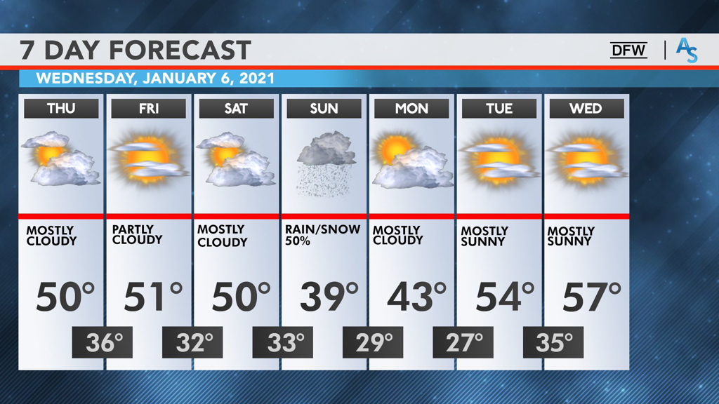
END OF THE WEEK: The persistence of a fairly gloomy pattern will result in relatively cool temperatures today with most of the region failing to get out of the 40s. There’s a minimal chance of some spotty showers here and there but it will likely be a cold, overcast day for much of North Texas. Temperatures will largely remain the same for Friday with DFW barely reaching the 50s, seeking up for a likely freeze taking place overnight into Saturday. The clouds will break at some point on Friday, giving way to pockets of sunshine to break up the otherwise dull, gray clouds. Saturday will be really similar to Friday as well, but as it transitions into the night, it gets a lot more interesting. DOES DFW BREAK THE DROUGHT: Wintry weather is a fickle part of weather around here. Some years it’s easy to get multiple events. Other years are more of the snowless status quo. This winter has, so far, been a continuation of the last 5 years. DFW hasn’t seen any snowfall greater than an inch since March of 2015, making it the 3rd longest drought in recorded history. It’s been difficult, time after time, seeing what looks to be a promising signal of winter weather, only to be left with flurries at best or cold rain at worst. However, this weekend could be the end of that drought. A classic bowling ball low is projected to sweep across Texas from the pacific overnight Saturday and through Sunday. This type of upper level pattern has a history of bringing snow to all parts of Texas and is ripe for both cold air and moisture. If you are wanting to see a good snowstorm, this is exactly what you want. In addition, the larger scale blocking patterns are also extremely promising, reminiscent of those back in February of 2010 when DFW set the record for highest snowfall in one day. Most of our near misses haven’t had a good upper level pattern like this—it’s always been a case of trying to find the cold when we have moisture, or trying to find moisture when we have the cold. However, while this pattern is precisely what we want for snow, it doesn’t guarantee it. The model guidance, then, becomes very important for our confidence on what might happen this weekend. In general, there have been two predominant solutions shown by the models. One solution was to have a fairly strong low pressure system move southward over Texas and into the gulf, bringing the bulk of the snow to Central Texas. The other solution was to have a weaker disturbance move over central texas and take a more northern track, resulting in more snowfall north of Interstate 20. These two conflicting solutions had made it difficult to forecast what would happen over the past few days. However, just in the last few runs, the models have all trended towards a different, compromising solution: a stronger, more northern low tracking over Texas. The amount of precipitation we have won’t be an issue, as there is almost unanimous agreement that North Texas will see a lot of moisture. The question now becomes about where the upper level low will track and where the freezing line will be. We’ve come to a general conclusion that a wintry mix is likely and it’s probable to see some light snow on Sunday. While model runs have shown the possibility for convective banding and genuine snowfall accumulation, it’s best to wait it out a few more days and see what trends endure and what trends fade. What we do know is that ensemble guidance is already showing some of the strongest signals for winter weather in the last decade and anything is possible this far out. We’re keeping it at a modest 50% wintry mix for Sunday, but we encourage everyone to continue to follow along for future updates. Nothing is off the table and be prepared to make adjustments to your schedule if trends continue. It’s been a long time since DFW had good snow and this storm is shaping up to be our best shot in years. As we get closer to the weekend, continue to follow along with the NWS and your local mets to see how this situation develops. If this were a drive in football, an interception would be just as likely as a touchdown. Stay alert, stay warm, and stay weather aware! -Colin Welty |
Archives
March 2023
Categories |
 RSS Feed
