
|
Hello ApexStorm followers! I’m here with another blog update specifically focused on the upcoming winter storm for NTX. I’ll construct this blog a little differently than I normally do but even as we are less than 24 hours out, we’re still dealing with many uncertainties. And yes, I said snow. I’m pretty confident now that DFW will end this snow drought. WHAT WE KNOW: An upper level low is currently sitting over Colorado and is forecasted to move over Texas, starting tonight in the panhandle and moving through Texas until Sunday night. Associated with the upper level low will be a larger amount of QPF (precipitation) than normal due to higher gulf moisture and seasonably cool temperatures. The blocking pattern and upper level dynamics match up nicely to previous major snowstorms in DFW’s history, reminiscing the famous February 2010 snowstorm where parts of the area got a foot of snow. These upper level dynamics are extremely complex and result in a high potential for variability due to the possibility of snow banding and heavy rates of snow, in addition to thermal cooling from high precipitation rates. We also know that areas south and west of here, in places such as Abeliene, Lubbock, and Waco, will receive measurable snowfall. While it’s extremely likely that DFW will receive a dusting, we can certainly say the aforementioned regions will get snow. The track of this low will vary but there is enough guidance from the models showing snow that there will likely be some high totals across Central Texas. WHAT WE DON’T KNOW: The track of the ULL can still change. Models have somewhat come to a consensus that the low will travel across Central Texas, but it could still change by upwards of 50 miles. This track, if more southern, would likely leave DFW with only a dusting. If it went more northern, however, we could be seeing a multi inch storm. It’s extremely complex and we likely won’t know the track of the low until mere hours before. In addition, this setup is conducive for heavy banding of snow. These bands of snow are highly erratic and difficult to predict. While we’re pretty certain on where the higher snow amounts will be, localized heavy bands are likely across all parts of Texas. These localized bands could drop up to 4 inches of snow regardless of where they pass and cool temperatures, which means that anyone who gets a band over them will have higher snowfall amounts than areas around them. The timing of the changeover will also influence amounts. Global models are calling for the switchover to occur after noon, while high resolution models are calling for the switchover before noon. QPF will maintain regardless of what precipitation type it is, so the earlier the changeover, the higher the amounts. 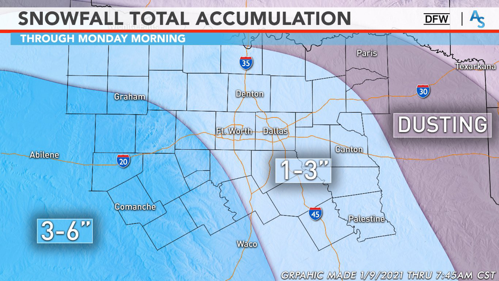 WHAT WE ARE PREDICTING:
The Red River down to the edge of the metro area will likely only see up to an inch, if even a dusting. We’re calling for the bulk of the DFW metro to see between 1 and 3 inches of snow with the potential for higher amounts with localized banding. Areas south and southwest of DFW will see between 3 and 6 inches of snow with localized heavier amounts possible as well. This forecast lines up with most of the professional meteorologist’s opinions as well, such as the legendary Steve McCauley, who is calling for 1-3 inches for DFW as well. This forecast is just that—a forecast. It is SUBJECT TO CHANGE right until the event and we have moved into nowcasting. Pay attention to radars and local meteorologists as this has the potential to be a massive bust or a massive over-performing system. For now, stay warm, stay alert, and stay weather aware! -Colin Welty |
Archives
March 2023
Categories |
 RSS Feed
