
|
Good Monday Morning, North Texas! Jonathan here! Donovan will likely be making a weather video this afternoon and not this morning, so I will be making a morning blog, and we've got a lot to talk about. TODAY: Today will be one of the most concerning days of this week, with severe weather in the forecast. The Storm Prediction Center has placed DFW in a level 1 marginal risk of severe storms. This may be upgraded to a level 2 slight risk, and possibly a level 3 enhanced risk for many reasons. 1) I was looking through the latest model guidance and it appears that surface based instability may approach 2000 across the DFW area. Earlier, 500 was the forecast on the scale, so indeed a major increase. 2) The capping inversion, which is a layer of warm air in the atmosphere than reduces and prevents severe thunderstorm development and cause elevated thunderstorms, which is what happened in our southwestern counties yesterday morning as that area of rain moved NE, dropping a quick quarter inch across the southern half of the metroplex. This won't be the case today, so we will monitor the threat of significant severe weather. A severe thunderstorm watch may be issued later today, and I can't completely rule out a tornado watch because significant tornado parameters looks fairly impressive this morning from soundings and morning guidance. I'll keep you updated if any watches are posted. It appears that we may have a squall line of strong to severe storms later this evening, as well as discrete supercells this afternoon. The main threats look to be large hail up to golf ball size, some possibly larger, and 60-70mph winds. Isolated tornadoes are also possible, especially across the western and northern half of North Texas. Follow me @wx_dfw on twitter for updates all afternoon, as well as check Donovan's as well. Again, he probably will be posting a weather video this afternoon which will inform us on latest weather forecasts, so make sure to frequently check the website and see if he has posted it. The next several days: Widespread rain and thunderstorms (at least 70% coverage) the next several days, which mainly a flooding and heavy rain threat later this week. Widespread storms are likely all day tomorrow will flooding becoming a possibility, and a strong cold front will aggravate this storm development. This front will knock temperatures down into the 40s for highs on Wednesday will a widespread cold rain. I cannot completely rule out some freezing rain across our far western or northwestern counties, but ice accumulations, if any, will remain minimal. I'll let you know if this changes as the NAM continues to change it's outcome Wednesday afternoon. Widespread rain continues to be likely into Thursday, with another cold front next weekend bringing widespread storms, some severe next Saturday, with the cold front possibly bringing in cooler and much drier air, and it may give us a small break next Sunday before rain may return by next Monday. Anyways, stay up to date with forecasts today as we may have severe storms this afternoon. Your seven day forecast is down below. Have a great day! -Jonathan 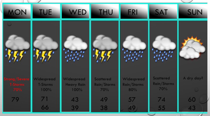 |
Archives
March 2023
Categories |
 RSS Feed
