
|
Chilly Start - Temperatures are in the upper 30s to low 40s across the board in north Texas, which is a classic February morning in North Texas. We will not warm that much today, with some places warming ten degrees at best. Today will be a mostly cloudy day with a broad southwest flow aloft, and scattered showers will be possible throughout the day beginning after 10AM. It is one of those cases where it is nearly impossible to predict exact start/stop times, but prepare for rain at any time during the day. Rain amounts should stay below 0.3ths of an inch today. We will only climb to the low 50s for highs. Tomorrow/Thursday - Clouds will remain in place with a broad southwest flow, but some rain will remain possible during the early morning hours. Highs will climb to the upper 60s tomorrow, with some touching 70. Then, on Thursday, we get much drier air, and temperatures will climb to the upper 70s, with some touching 80s in the urban areas. The record high for February 15 is 83, set in 2005. Friday and the Weekend - A cold front pushes from the south, which will make for scattered to numerous showers and storms, mainly during the late afternoon and evening hours. I do think most of the winter weather will stay to the north of us, and we will only see rain at that time. And the rain continues into Saturday, where widespread rain is possible during this time, something we have been wanting for over three months or so. Highs will be in the low 50s for Friday and Saturday. Then, on Sunday, we trend much drier with clouds clearing up, although we still could see a few showers during the morning hours. Highs should be in the low 60s as we warm up. Next Week and Beyond - Monday will just be a mostly cloudy day before some rain chances return during the rest of next week. If you've been catching the trend, it seems like rain will be possible almost everyday after this Thursday. Thankfully, the upper air pattern will keep the really cold air bottled to the north, which will make this week generally average. No signs of any terribly cold arctic blasts, snow, or wintery precipitation for the rest of February. See the Texas Weather Discussion Video for more details. 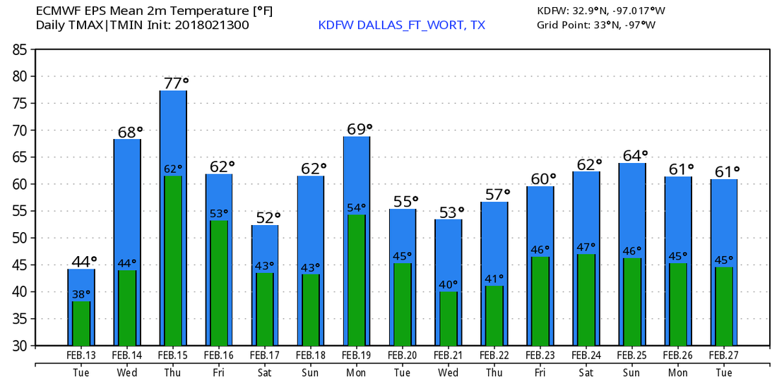 |
Archives
March 2023
Categories |
 RSS Feed
