
|
Radar Check - No thunder, but widespread rain continues over the DFW metroplex. Due to below freezing temperatures, some of that rain is turning into freezing rain and sleet, where reports of freezing rain has been made near Weatherford and surrounding areas. 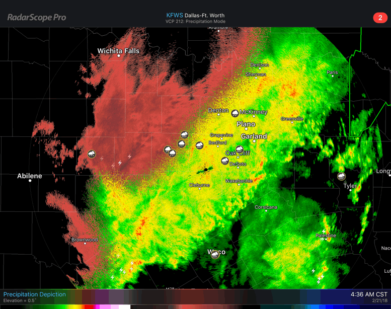 I do think that some of this freezing rain has the potential to leak into Tarrant and Dallas counties later this morning. Plan for another wet commute to work and school this morning, and be especially careful since some roads, bridges, and overpasses may be icy in some spots. Widespread rain continues through the afternoon hours. There will still be the threat of some wintery precipitation, but most of it will be confined to the western parts of North Texas. We should struggle to get out of the 30s today due to cold air advection. Rainfall Totals - Some places in North Texas have already measured over an inch of rain, and it is not even the afternoon yet. We can expect an additional 1-2" this afternoon and evening. The good news is, we do get a break from the rain this evening and tomorrow morning, but some scattered showers can't be ruled out as you head out the door. However, that break won't last long at all, as scattered showers and storms return to the state during the afternoon hours. An additional 1/2-1" of rain can be expected from that. Tomorrows high will be in the low 40s. Friday and Saturday - Some places to the south of the immediate DFW area could have a wet commute starting off, but the north won't stay dry that day. Rain overspreads the north during the late morning/afternoon hours once again, but it shouldn't rain all day. Friday's high will be in the mid 50s. A surface front comes through on Saturday, bringing additional chances for scattered showers and storms, mainly during the morning hours. The front shifts to the east very quickly, and begins to affect the Ark-La-Tex area, where we do note a risk for severe weather has been noted for Saturday for that area. For DFW, once the front passes by, there is a chance we could see some sun peak out during the afternoon. Highs should be in the low 70s. Sunday - For the first time in a while, Sunday should be a completely dry day! Sun will break out with highs in the low 60s. Next Week - The early part of next week remains pretty dry, then scattered showers and storms return during the latter half of the week, but shouldn't a widespread rain event like this week. See the Texas Weather Discussion Video for more details.  |
Archives
March 2023
Categories |
 RSS Feed
