
|
Radar Check - For the first time in a while, the radar is actually quiet here for much of North Texas. We remain dry this morning. We nearly dodged a bullet for those that are Tarrant and Dallas counties. Had the temperature been two or three degrees cooler yesterday afternoon and evening, roads would have been iced over across much of the metro. For now, we are still in the low to mid 30s this morning, and we should warm to the mid 40s this afternoon. Rain returns to the region during the brunch hours. Counties to the west are still dealing with the threat for freezing rain and sleet, where a Winter Weather Advisory remains in effect until 10AM and 1PM for our western counties, including Denton. Friday - Rain returns to the region tomorrow morning, though the northern half should remain dry during the morning. Rain then overspreads the region during the afternoon hours, where an additional 1/2" should be expected. We should warm substantially with highs in the upper 50s/low 60s. The Weekend - A surface front makes it way to the east during the morning hours, which will bring more chances of showers and storms. They remain scattered at first, becoming more organized during the afternoon hours. Some storms could turn marginally severe, posing the threat for mainly large hail and damaging winds to the east of I-35. This is where the SPC has a slight risk defined for the northeast part of the state. 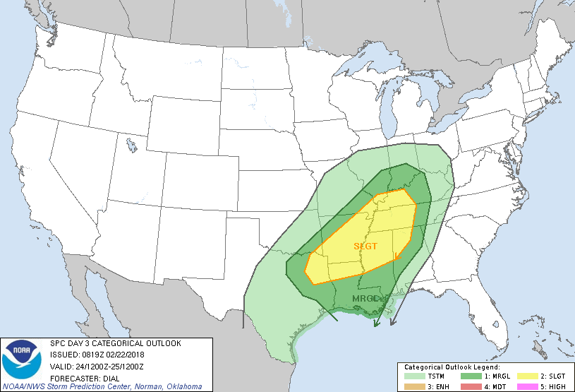 Some storms could be strong while scattered, but there is a good chance that instability won't kick in until the afternoon. Once the surface front pushes through, we should remain dry for the rest of the weekend with a mix of sun and clouds. We should be in the upper 60s on Saturday, and mid 60s on Sunday. Next Week - We remain dry on Monday, then a deep surface low forms over Kansas on Tuesday, which will bring the chance for rain at times on Wednesday as well. The latter half of the week remains dry. The high for most of the week should be in the mid 60s. See the Texas Weather Discussion Video for more details. 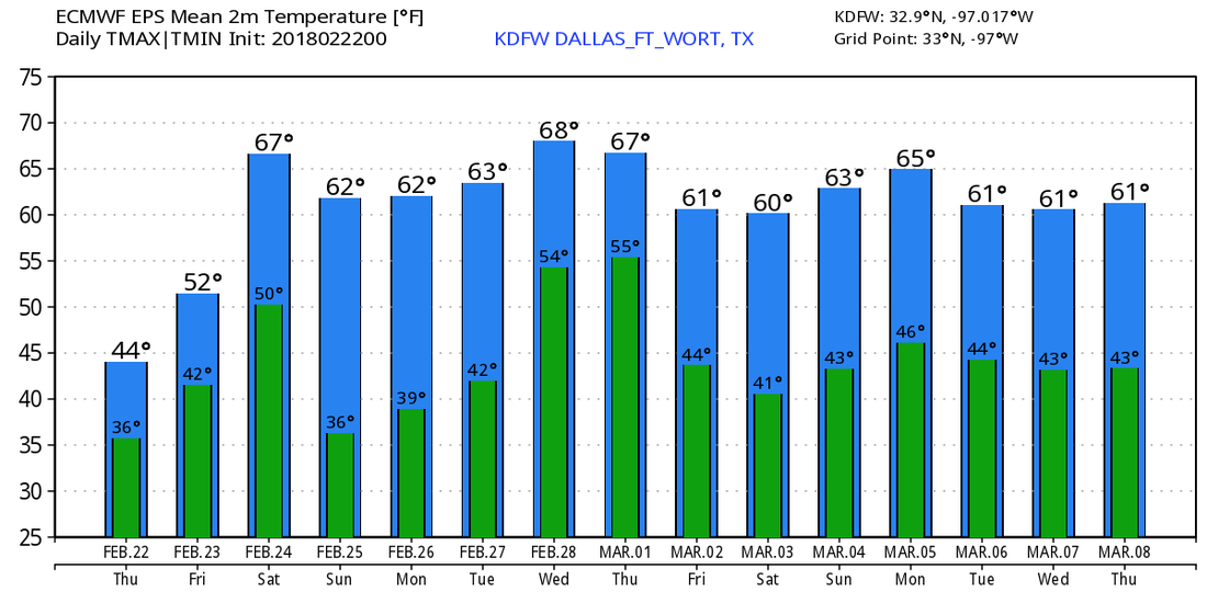 |
Archives
March 2023
Categories |
 RSS Feed
