
|
Our current upper air pattern brings the type of weather to North Texas that doesn't really change much. We will continue to forecast mostly sunny skies with a couple of clouds. Heat levels will be on the rise again, and highs will be closer to 100° today. The overall weather for the weekend will stay the same as well. We will continue to forecast very hot days with sunny afternoons. Highs will be mostly in the upper 90s for the weekend. NEXT WEEK - And the dry pattern stretch continues through most of next week as well as we see no evidence of rainfall for at least the next ten days. Expect highs to be in the mid to upper 90s for all of next week with mostly sunny skies. Lows will be in the mid to upper 70s. See the Texas Weather Discussion Video for more details. 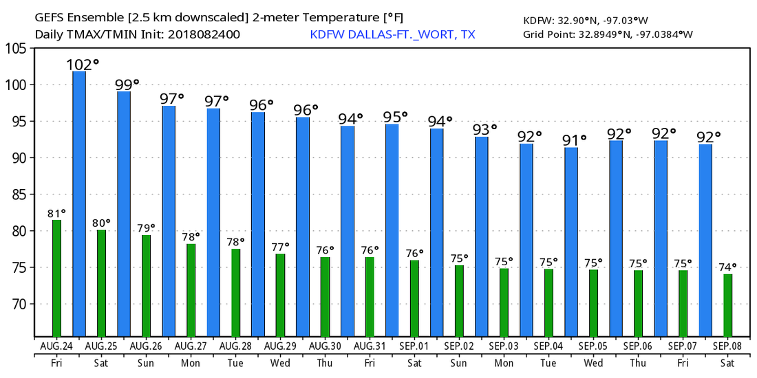 TROPIX - Hurricane Lane is affecting much of the Hawaiian Islands but continues to weaken just to the west of there. It will weaken to a category two later today. The main impacts from this storm will include lots of heavy rain and flooding.
In the Atlantic, a well organized wave is emerging from the coast of Africa this morning, but lots of dry air and cooler water means there is no chance of development this weekend. The rest of the Atlantic Basin remains quiet. ONE YEAR AGO TODAY - Hurricane Harvey was approaching the middle Texas coast. It would make landfall at around 10PM the next day between Port Aransas and Port O'Connor. Hurricane Harvey is tied with 2005's Hurricane Katrina as the costliest tropical cyclone on record, inflicting 125 billion dollars in damage, primarily from catastrophic flooding in the Houston area. It was the first major hurricane to make landfall in the US since Wilma in 2005, ending a record 12-year streak in which no hurricanes made landfall at the intensity of a major hurricane throughout the country. In four days, many areas received more than four feet of rain as the system slowly meandered over eastern texas and adjacent water, causing unprecedented flooding. |
Archives
April 2024
Categories |
 RSS Feed