
|
MILD MORNING - Temperatures are in the upper 70s to low 80s this morning, very standard for this time of the year. I am just waiting for the days where we can start the morning off in the low 40s. Today will be another hot and humid day with more sun than clouds. Highs will be in the 94-98 degree range. Not much change in the forecast tomorrow; Highs will continue to be in the upper 90s with a mostly sunny sky with a few clouds; very typical late August weather. FOOTBALL WEATHER - For the high school football games happening in North Texas tomorrow, most games should be played under a clear sky with temperatures around 95° at kickoff, falling to the low 90s by the end of the fourth quarter. The Mansfield ISD main high schools will be traveling to Oklahoma tomorrow for their first inaugural Border Brawl games (7-7:30p kickoffs), scattered across the Tulsa/Broken Arrow area. The temperature will be in the 91-93° range at kickoff, falling to around 85° by the final whistle. THE WEEKEND - Not much change. We continue to remain mostly sunny and dry under humid conditions. Highs for the weekend will continue to be in the 93-99 degree range with a few clouds. NEXT WEEK - Global models have been hinting at some tropical moisture advecting from the Gulf during the very early parts of next week. If that were to be the case, our airmass would become unstable, which means we would introduce a chance of widespread, scattered showers and thunderstorms during the day with highs in the upper 80s to low 90s with cooler temperatures in the areas that experience the most rain. That rain would continue through at least Thursday. Meanwhile, the European model shows a tropical low impacting the Alabama coast, then making a hard left turn towards the Ark-La-Tex area, but does not reach North Texas. If that solution verifies, we would keep a dry forecast for much of next week with highs in the mid 90s. See the Texas Weather Discussion Video for more details. 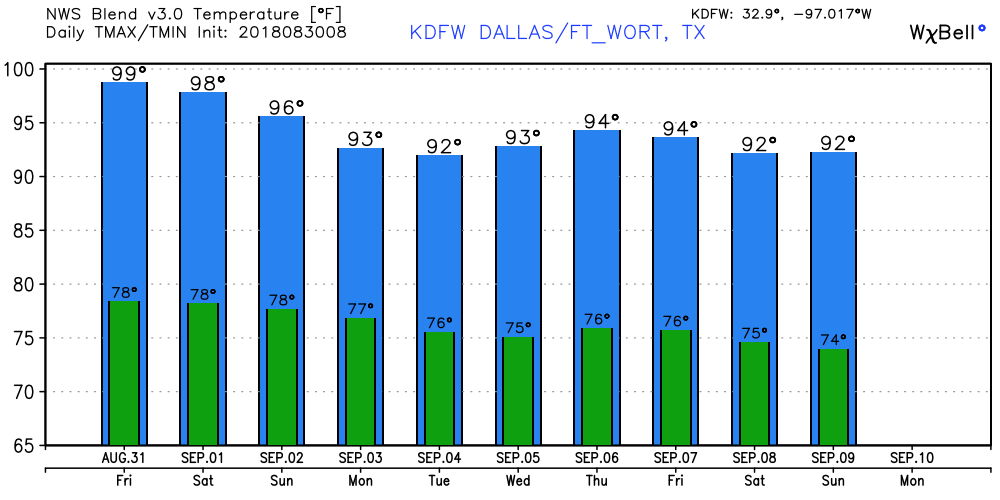 TROPIX - A tropical disturbance is continuing to move off the coast of Africa; the NHC subsequently gives it a 80 percent chance of developing over the next five days. This is still a few thousand miles away from the U.S., and it remains unknown if this will stay out in the open water, or impact any land masses. However, if this become a tropical storm, it's name will be Florence. 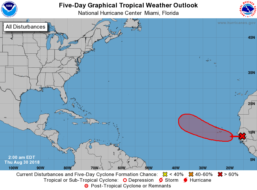 Global models are continuing to indicate the Atlantic Basin getting more active in the next few weeks in terms of tropical weather. This is perfectly normal as we are nearing the climatological peak month of hurricane season.
|
Archives
March 2023
Categories |
 RSS Feed
