
|
RADAR CHECK - Lingering showers and thunderstorms continue to move to the northeast this morning. They will continue to move rapidly to the northeast this morning, mostly clearing out by the afternoon. Temperatures are generally in the low to mid 70s this afternoon.  TOMORROW AND THURSDAY - We really start to dry out by the latter half of this week at the trough lifts more to the north. Each day will feature a mix of sun and clouds with afternoon highs in the mid 90s. A couple of isolated, "pop-up" showers and thunderstorms will still remain possible during the afternoon, but mostly communities stay dry. FRIDAY AND THE WEEKEND - Not much change for the weekend. We will continue to stick with a dry forecast with a mix of sun and clouds. Some moisture could find its way into some parts of North Texas, so an isolated storm or two is not ruled out. Highs each day will be in the mid 90s. NEXT WEEK - Global models have been indicating a trough setting up in the Corn Belt which will aid in pushing a cold front to the south on Tuesday. This would of course mean increased chances of scattered showers and thunderstorms and cooler temperatures by a few degrees. The latter half of next week remains unsettled as a result, and we will continue with a chance of at least isolated showers and storms through at least Thursday. Highs each day will be in the low 90s. See the Texas Weather Discussion Video for more details. 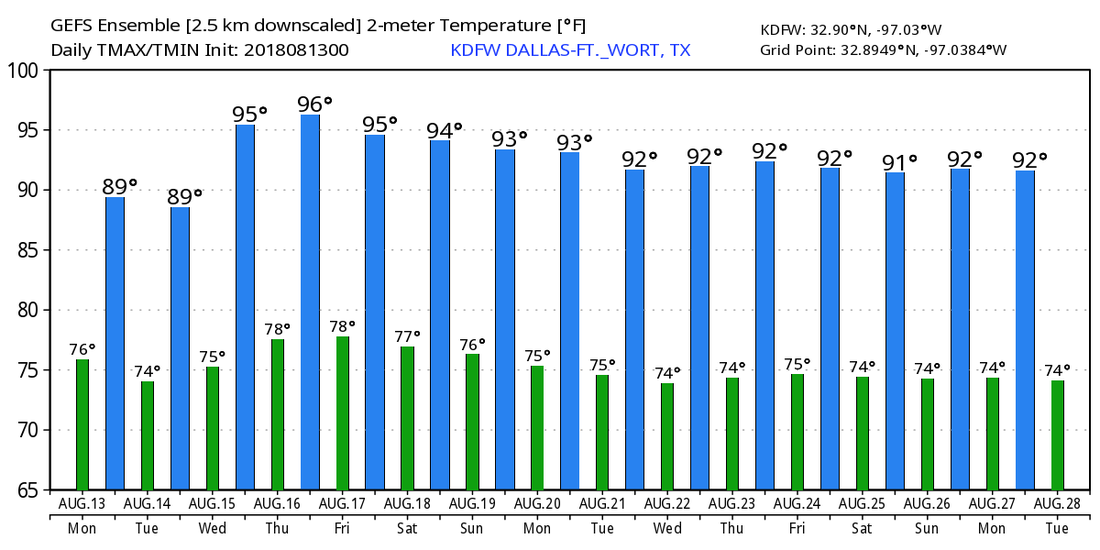 TROPIX - A small disturbance in the Central Atlantic has a 40 percent chance of developing within the next 48 hours. This could become a subtropical or tropical cyclone before late Thursday, when it moves northeast into cooler water. This poses no threat to land. The rest of the Atlantic Basin remains quiet.
|
Archives
March 2023
Categories |
 RSS Feed
