
|
COULD BE WET? - We are starting the day off with sunshine in full force this morning, but west-moving showers and thunderstorms are possible by the afternoon hours into tonight as a weak impulse in Central Texas continues to affect our weather pattern. The chance of any one spot getting wet is in the 30/40 percent bracket. Keep in mind that it will be nearly impossible to predict exact start/stop times of the thunderstorms due to the scattered, random nature of them, but the main window of the most coverage will be from 12:00 to 8:00 PM. Highs this afternoon will be in the mid to upper 90s. A front approaches from the north and stalls near the North Texas/Oklahoma border on Saturday, which will keep our weather unsettled over the weekend. We continue to forecast a mix of sun and clouds afternoon showers and thunderstorms on both days. Highs will be in the mid 90s through the weekend. NEXT WEEK - The front slowly fizzles out early next week, but enough moisture and instability will stay in place for our weather pattern to be unsettled for a good chunk of next week. A mix of sun and clouds with showers and thunderstorms are possible each day with highs in the mid 90s. The upper high strengthens during the latter half of the week, which means any lingering storms will likely become fewer in number by Thursday and Friday. See the Texas Weather Discussion Video for more details. 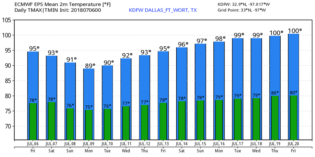 TROPICS BECOME ACTIVE - We have our first hurricane of the 2018 Atlantic Hurricane season. Hurricane Beryl is located near the Lesser Antilles and Africa in open water. It has maximum sustained winds of 80 mph, and is moving to the northwest at 15 mph. It is forecast to remain a hurricane as it impacts the lesser Antilles, and a hurricane watch may be required for the island. We expect this system to dissipate by Tuesday before it reaches Cuba with no threat to the U.S at all. 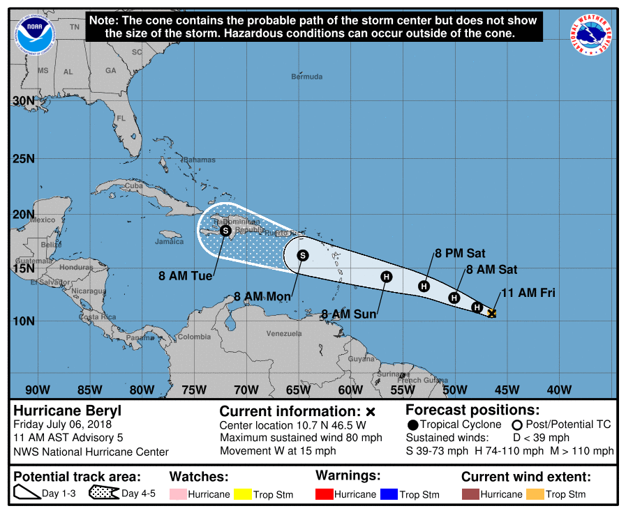 Meanwhile in the Central Atlantic, a disturbance that is a few hundred miles off of the Carolina coast has a 70% chance of becoming a tropical depression within the next two days. Global modeling suggests that this could become a tropical storm as it hugs the U.S. East Coast. This will not impact our weather in Texas.
|
Archives
March 2023
Categories |
 RSS Feed
