
|
Temperatures continue to be in the low to mid 80s this afternoon under a clear sky. The radar is actually clear this morning with no isolated drizzle about. Today will be another hot day with afternoon highs in the upper 90s. If DFW can stay below 100 today, this would break our streak of consistent 100 degree heat. REST OF THE WEEK THROUGH THE WEEKEND - We fall into a more tolerable kind of hot, meaning, it won't be as hot as this weekend or late last week. Highs will still be closer to 100 degrees with mostly sunny skies. The overall pattern will not change much this week. Lows will be in the upper 70s/low 80s. NEXT WEEK - A trough sets up in the lower Midwest near the Corn Belt that will help in pulling a cold front down Monday morning. That would mean chance of mainly morning showers and thunderstorms with cooler temperatures during the afternoon. The most widespread activity looks to occur during the morning with afternoon highs in the mid 90s afterwards; that's about 20 degrees cooler than the highs last week. It's also worth noting that the Climate Prediction Center suggests on their new 6-10 day temperature outlook that we have a fair chance of seeing slightly below average temperatures. That doesn't mean it will be cool, just slightly more tolerable. See the Texas Weather Discussion Video for more details. 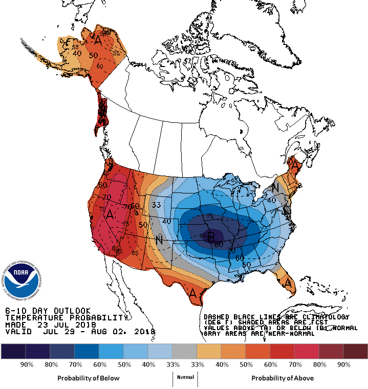 TROPICS - All is quiet in the Atlantic Basin, and no new tropical cyclones are expected through the weekend.
|
Archives
March 2023
Categories |
 RSS Feed
