
|
RADAR CHECK: A complex of loud showers and thunderstorms that we probably all woke up to at 2:00 in the morning is moving to the east this morning. The cloud cover as a result should begin to decrease as we progress throughout the day.  SEVERE WEATHER POSSIBLE AGAIN THIS EVENING: Before you read any further, understand that this is definitely something that we do not deal with every year; a late spring severe weather setup. This just goes to show you that severe weather can happen at any time of the year, and is not 'unprecedented' or 'uncommon', as some people like to think. Keep in mind that this forecast can and will change, so be sure to stick with our twitter, facebook, and the blog to stay up to date. Regardless, we have the potential for significant severe weather this afternoon across North Texas. The Storm Prediction Center upgraded portions of North Texas to an 'enhanced' (level 3 of 5) risk of severe storms this afternoon and evening. This does include the entire Dallas/Fort-Worth Metroplex, extending to the east near Mount Pleasant. The standard "slight" (level 2 of 5) risk of severe storms runs through Abilene and surrounds the enhanced risk area, then runs east through the Ark-La-Tex region. A "marginal" (level 1 of 5) risk of severe storms surrounds the slight and enhanced risk areas and runs a bit farther to the northeast and west. 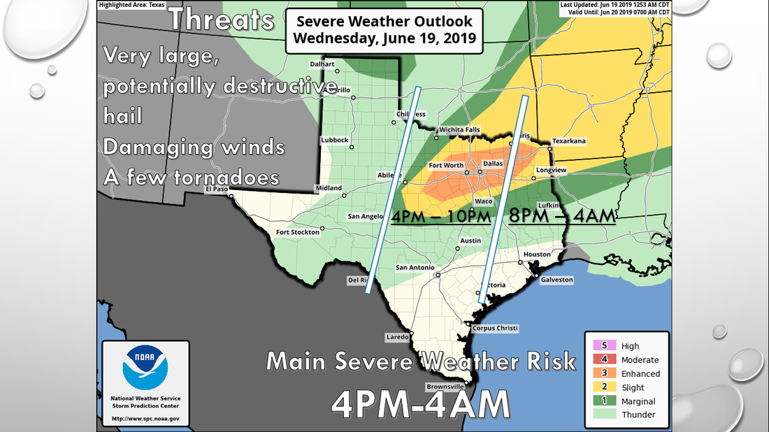 As I say with any severe weather risk, please be advised that it is bad practice to get fixated with these risks. Storms do not know where these lines and colors are and do not follow a map. Additionally, these severe weather setups this late in the season can change, even with the most minute details, so it is imperative that you are always on our feed today. HOW IT LOOKS NOW: The storms that moved through the region this morning actually do play a role in how storms develop this afternoon. The storms left a few outflow boundaries for the storms to "play around with". These are the areas where the storms will initiate this afternoon and may tap on to some enhanced low-level shear. We will talk about that in a second. Once the clouds start breaking across the metroplex and we see mostly sunny skies, highs will be in the mid to upper 90s this afternoon in a very humid airmass. It will truly feel like a hot summer day this afternoon. This will not be good in this scenario, as that will be a catalyst for the atmosphere to become extremely unstable this afternoon and evening across North Texas. Surface-based CAPE values will exceed 6000 j/kg in some places, making for a "powder-keg" situation for the region, and storms may turn nasty if they take advantage of it. TIMING: Although computer models are painting a different picture, we expect severe thunderstorms to initiate in West Texas at around 4:00 PM this afternoon. Keep in mind that this development will likely be explosive and become severe very quickly, since we will not have a capping inversion to keep the storms in place due to an extremely unstable airmass. Our main severe weather risk will last until 9-10PM for most of the metroplex, but most of the North Texas region can expect severe storms anywhere from 4PM to 4AM Thursday morning. THREATS: Supercell thunderstorms will develop this late afternoon and progress into the evening hours. These storms will have the greatest potential of producing very large hail up to the size of baseballs. Keep in mind that if we see a long-lived supercell, that one will have the highest probability of producing softball sized hail somewhere in the enhanced risk region during the late afternoon to early evening hours. Damaging wind and a few tornadoes will be possible as well. If any storms can interact with any greater weak low-level shear, then the tornado potential will be maximized in that zone. However, the extreme instability should compensate for the lack of low-level shear, so we will continue to mention the chance of a few tornadoes in North Texas this evening. Once the storms congeal into a cluster or a squall line, the threat for damaging winds and some hail will be maximized. The main batch of storms should move out of the state by midnight. RAIN: Heavy rainfall rates are possible with any severe storm today, and 1-2 inches of rain as a whole can be expected. We do not expect any widespread flash flooding issues, however localized street flooding is possible with heavy downpours. TAKE A DEEP BREATH: We are all too familiar with very large hail events across this region here in North Texas, and this is nothing out of the ordinary. Just take a deep breath, and make sure you protect your property for any hail in case of the worst-case scenario. Not everyone will get hail, so don't be upset if you do not get anything. Further, make sure you are staying up to date with the ever changing forecast. This means having a reliable way of receiving warnings. Every home and business should have a NOAA Weather Radio, but you should really consider investing in a great smartphone app like this one in order to receive warnings in a timely fashion. If you need some guidelines on how to prepare for severe weather, information can be found here. REST OF THE WEEK: Once the severe weather passes, the rest of the week will feature very hot, dry conditions with highs in the mid to upper 90s. It will feel more like a hot, summer day with heat indices in the triple digits. THE WEEKEND: Not much change. We do go back to seasonal averages for the year with highs in the low 90s with a mix of sun and clouds. NEXT WEEK: Most of next week will also be dry with highs in seasonal averages for this time of the year with daily chances of "isolated, mostly morning showers and thunderstorms". See the Texas Weather Discussion Video for more details.   |
Archives
March 2023
Categories |
 RSS Feed
