
|
Chilly Start - Most places are starting the morning out in the upper 40s to low 30s. Cold air advection will keep us in the upper 50s today. We will only see a few spots hit 60 degrees for the high. Late Freeze Incoming? - From a trough in the north, and another deep nor'easter forms just off of the Atlantic Coast, a little bit of cooler air will be pushed into the state during the morning hours. Highs will only be in the upper 50s with abundant sunshine. On Thursday morning, we turn colder, and temperatures will fall into the mid 30s in most places, with some reaching down into the low 30s. Some isolated freeze spots will be possible early Thursday morning, with patchy frost possible for parts of the region. Then we warm up on Friday morning, with lows only in the upper 40s. Highs will be in the upper 60s and low 70s on Thursday and Friday. We are forecasting a mix of sun and clouds on both days, with more clouds than sun on Friday. The Weekend - Clouds will stick around on Saturday, and moisture returns, which means we will deal with a few isolated showers and thunderstorms at times during the day. Most of the rain stays to the east of DFW. Some thunder is possible, but for now, the severe weather threat looks fairly low. We will be in the upper 70s/lower 80s on Saturday, but cooler air gets pulled into the state on Sunday, and we will be in the mid 60s with a mix of sun and clouds. Next Week - Not much change. We stay dry with a mix of sun and clouds for all of next week. Temperatures will be in the mid 60s for most of the week, increasing to the low 70s on Thursday and Friday. See the Texas Weather Discussion Video for more details. 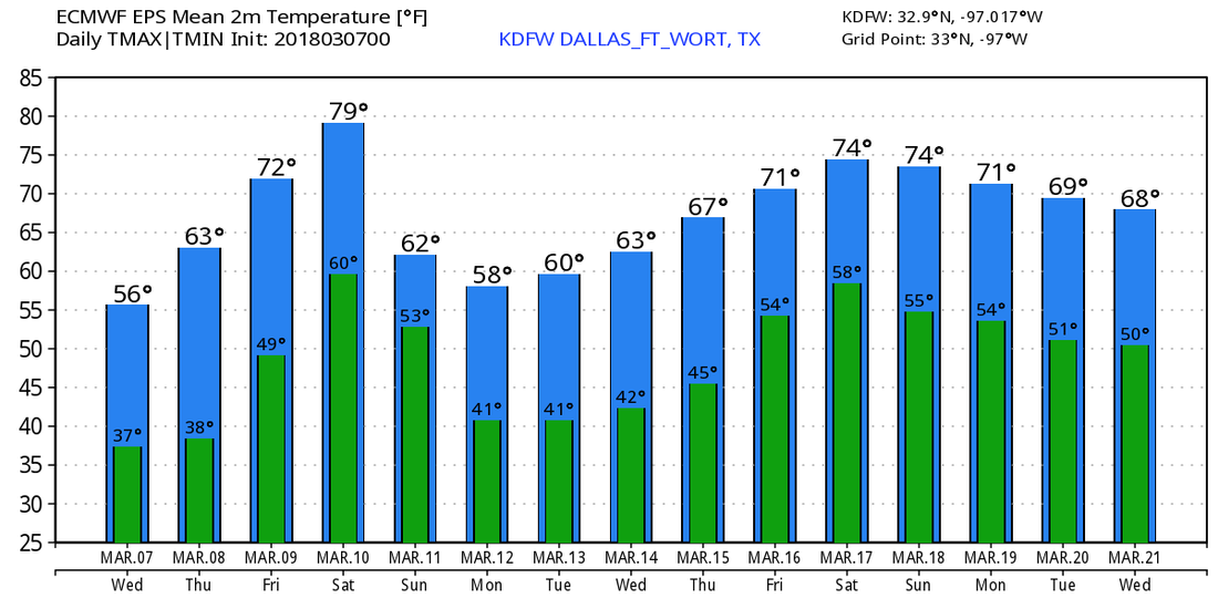 |
Archives
March 2023
Categories |
 RSS Feed
