
|
OCEAN OF HUMIDITY: A hot, muggy airmass will hang over North Texas for the foreseeable future, meaning each day, we will forecast partly to mostly sunny skies, which a chance of a random isolated shower or storm. There isn't a way of knowing exactly who will get the storm, just remember to check the radar from time to time. The radar will be very quiet this afternoon, but a weakening complex of severe thunderstorms will move southeast overnight, and rain is possible in some areas by 1PM. Highs will be in the mid 90s, seasonably warm for the beginning of June. THE WEEKEND: No real chance for the weekend. We remain dry, humid, and hot with mostly sunny skies on both days. Highs will continue to be in the middle to upper 90s. NEXT WEEK: We will introduce a chance of scattered showers and storms on Monday as Cristobal moves northward through Louisiana and Arkansas, but the general pattern will not change much. Mostly sunny, hot, humid days with mostly dry conditions. Highs will remain mostly in the middle to upper 90s through the week. There is some hint that one of those days could be the first 100 degree day of the year, but we will believe when we see it. 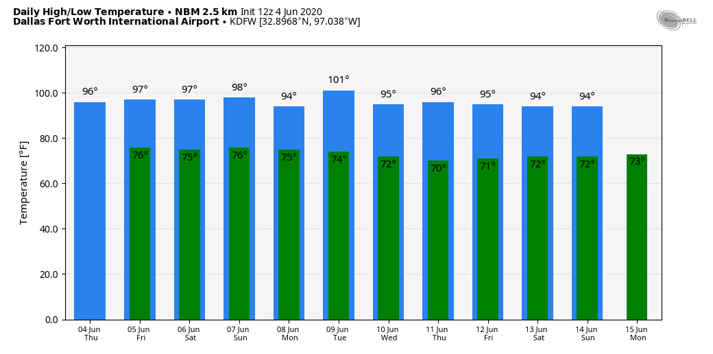 TROPICAL STORM CRISTOBAL: This morning, the system continues to weaken, as winds are down to 40 mph. The center of Cristobal was located over Southern Mexico, and is nearly stationary... A movement toward the east then northeast is expected later today, and a subsequent northward motion should occur through the weekend. On the forecast track, the center will move over the landmass of eastern Mexico today and tonight. The center is then forecast to move back over the Gulf tomorrow or tomorrow night, then the Central Gulf on Saturday. No significant change has been made to the NHC forecast track. The tropical storm is expected to move into the Louisiana coast Sunday night with winds of 60-65 mph. 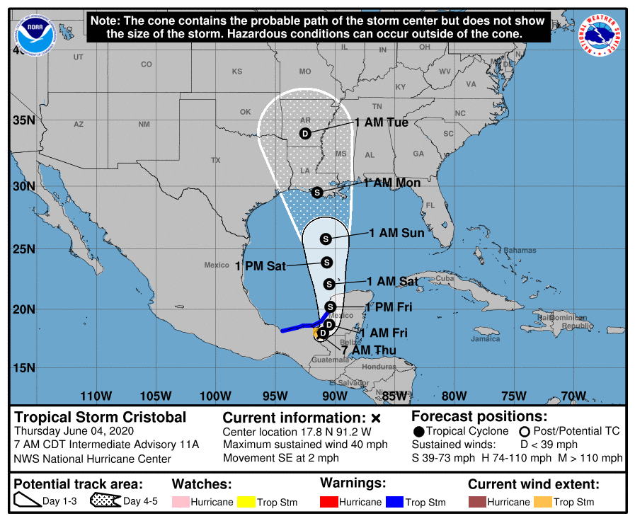 The circulation center will move through Louisiana and Arkansas Monday and Monday night, whilst weakening.
ON THIS DAY IN 1877: A tornado of F4 intensity touched down just to the west of Mt. Carmel, Illinois and moved northeast, devastating the town. 20 businesses and 100 homes were severely damaged or destroyed. 16 people and as many as 30 were killed, with 100 injured. Look for the next blog post tomorrow at around the same time... Enjoy the day! Donovan Neal Owner/Founder - ApexStorm |
Archives
March 2023
Categories |
 RSS Feed
