
|
NORTHWEST FLOW ALOFT: Moisture levels will begin to slowly increase today through next week as a northwest flow aloft builds across the South-Central US which will open the door for moisture, resulting in more chances of scattered showers and storms, MCS's, and more clouds. A complex of thunderstorms from Oklahoma and West Texas will gradually weaken and move into portions of North Texas after midnight. Not everyone will see rain, but the greatest chances lie for those closest to the Red River. Otherwise, we project a high in the 91-94 degree range this afternoon with the chance of isolated, mostly afternoon and evening showers and thunderstorms. Another complex of showers and storms will emerge from South Oklahoma and move south overnight on Saturday, arriving to most of the metroplex by daybreak Sunday. Each afternoon will feature highs in the low 90s with a mix of sun and clouds and fair nights. An afternoon shower or two can not be ruled out, but, odds of any one spot getting wet are only 10 percent during the afternoons. NEXT WEEK: Moisture levels continue to be above normal, and we will continue to insert daily chances of "isolated, mostly afternoon and evening showers and storms". Afternoon temperatures each day will be in the low 90s due to cloud cover and showers. Rain distribution will not be even, but many communities have a chance of seeing 1 to 1 1/2 inches during the week. 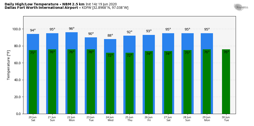 TROPICS: The Atlantic Basin remains very quiet, and tropical storm formation is not expected through next week. The SAL (Saharan Air Layer) could reach the Southeastern US by next week, setting the stage for vivid sunrises and sunsets, especially along the coast.
ON THIS DAY IN 1972: Hurricane Agnes deluged Pennsylvania and New York with torrential rains resulting in the most costly flood in U.S. history. In the Middle Susquehanna Valley of Pennsylvania, 24 hour rainfall amounts were generally 8 to 12 inches, with up to 19 inches in Schuylkill County. At Wilkes-Barre, the dike was breached, destroying much of the town. Flooding resulted in 117 deaths and $3.1 billion in damage. Look for the next Texas Weather Blog here tomorrow from Colin Welty... Have a great weekend! Donovan Neal Owner - ApexStorm |
Archives
March 2023
Categories |
 RSS Feed
