
|
HOT, HUMID DAYS: The radar is quiet across North Texas this morning, but we expect the return of isolated showers and thunderstorms this afternoon, accordingly. Most of the showers will come from around 12:00 to 9:00 PM, and the chance of any one spot getting wet is about one in three. The high will be in the low to mid 90s. There will not be much change tomorrow and Friday. Warm, humid days with "isolated, mostly afternoon and evening showers and storms". There is no way of exactly knowing when and where the storms appear due to the random nature. You just have to ensure to keep an eye on the radar if you have outdoor activity planned. Highs will remain in the 92-95 degree range. THE WEEKEND: Not much change; We will continue to roll with the persistent early summer forecast of "mix of sun and clouds with daily chances of isolated, mostly afternoon and evening showers and storms". Highs will be in the middle to upper 90s. NEXT WEEK: We expect an increase in the amount of showers and storms on Monday and Tuesday as a response of the tropical moisture being pulled to the north due to Tropical Storm Cristobal. The highest coverage will most likely come on Monday as Cristobal passes to the west of the state, on its journey northward. Highs will be in the low to mid 90s, lows in the mid 70s. 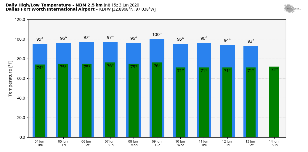 TROPICAL STORM CRISTOBAL: The system in the far southwestern Gulf of Mexico is packing sustained winds of 60 mph this morning. According to the forecast track, the center will cross the southern Bay of Campeche coast later today and move inland over eastern Mexico tonight and tomorrow. The center is then forecast to move back over the Bay of Campeche tomorrow night and Friday. Slight increase in strength is possible until the center crosses the coast, which, at that point, will weaken once again. Restrengthening is expected after Cristobal moves back over water tomorrow night and Friday. The latest NHC track places Cristobal on the Louisiana coast Sunday night as a high-end tropical storm. The main impact will come from heavy rain, flooding, and waterspouts/tornadoes. 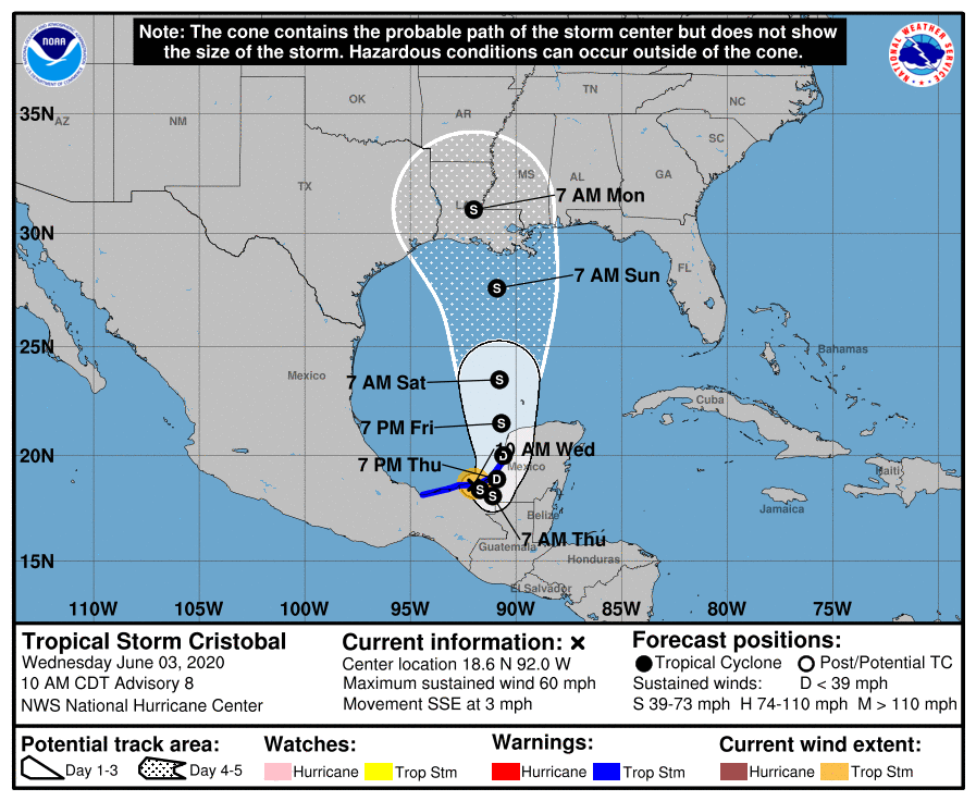 ON THIS DAY IN 1993: (This is something North Texans should be familiar with) Early morning severe thunderstorms produced huge hail across northern Oklahoma. Hail, up to the size of six inches in Enid, went through roofs, damaged three fighter jets at Vance Air Force Base, and did $500,000 in damage at a car dealership. Wind gusts reached 70 MPH at the base as well. Hail damage to crops was estimated at $70 million.
Look for the next blog update at around the same time tomorrow... Enjoy the day! Donovan Neal Owner/Founder - ApexStorm |
Archives
March 2023
Categories |
 RSS Feed
