
|
HOT TUESDAY: It was a very hot June day here in the metroplex and much of North-Texas. Here are some of the temperature readings at around 3PM... DFW AIRPORT 96 DALLAS LOVE 99 FTW MEACHAM 93 DAL-EXECUTIVE 98 FTW-ALLIANCE 94 FTW-SPINKS 99 ARLINGTON 99 GRAND PRAIRIE 99 ADDISON 97 MESQUITE 100 LANCASTER 99 In wake of a cold front, drier air and cooler conditions can be expected for the next few days. Overnight lows will be in the low 60s. Some of the cooler spots will see lows in the 50s. Some showers are possible in East Texas and the Brazos Valley. No severe storms, but the storms could produce heavy rainfall, and small hail. TOMORROW: After a rather rare June cold front, tomorrow will be a different kind of day. This morning, and early afternoon, we experienced dewpoints in the 70-75 degree range. Tomorrow, they will drop into the low 40s as much drier air takes over. We will be noticeably cooler with highs mostly in the upper 80s with a breezy northwesterly wind. The more south you go, the more of a chance you have of seeing low 90s. THURSDAY THROUGH THE WEEKEND: We will continue to enjoy lower humidity towards the end of the week with sunny days. Dry weather will continue through the weekend with sunny, warm days and pleasant nights. Cooler spots will drop to the 50s each morning, with low 60s generally across the board. NEXT WEEK: The weather pattern continues to look very quiet. Moisture levels slowly rise, and thus, a few showers could show up to the south over the latter half of the week, but no sign of any widespread rain for a very long time. 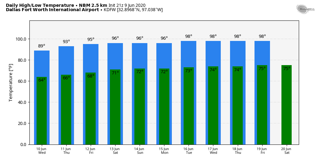 TROPICS: A non-tropical area of low pressure is located over the central Atlantic Ocean, a few hundred miles east of the Bermuda. Development of this system is highly unlikely due to unfavorable environmental conditions. The low is expected to dissipate in a few days. The rest of the Atlantic Basin is quiet.
ON THIS DAY IN 1953: An F4 tornado hit Worcester, MA causing 94 fatalities. The tornado touched down in Petersham, traveled through Worcester, and on to Southborough. Debris was carried eastward and fell in the Boston area. About 4000 houses and buildings were destroyed, totaling more than $52 million in damages. Look for the next blog update around the same time tomorrow... Have a great night! Donovan Neal Owner - ApexStorm |
Archives
March 2023
Categories |
 RSS Feed
