
|
A surface front that brought some heavy rains this weekend is now to the south, and behind that is drier air, which has in term kept rain to a minimal and dewpoints down, you still can't rule out the chance for an isolated shower or two as some tropical moisture still exists. I doubt that we will get into the mid 90s due to cloud coverage. For the Rest of the Week - The surface front to the south will dissipate, and an upper-level high moves to the northeast, which should keep things drier and just a little hotter for the rest of this week. You still can't completely say no a shower or storm, but on the bright side, I don't expect and 100-degree weather for a long time, which makes these temperatures below average for this time of the year, which I am not complaining about. The Weekend - Broad troughing in the North will allow a surface front to drop from the south, creating more chances for showers and storms mainly on Sunday. I don't think this will be another widespread rain event for now, but some locations could see some areas of heavy rain at times. Otherwise, expect to be in the middle 90s for the weekend, with things just a tad cooler on Sunday. The surface front won't bring down temperatures, but it should create more rain chances. Next Week - The chance for showers and storms will still exist Monday and Tuesday as the front stalls. I think the better chances for widespread rain will exist during Monday. The GFS shows an upper-high starts to build in the deep south, and if that verifies, the weather will trend drier and hotter. But, this is ten days out, and could very well change a lot. See the Texas Weather Outlook Video for more details. 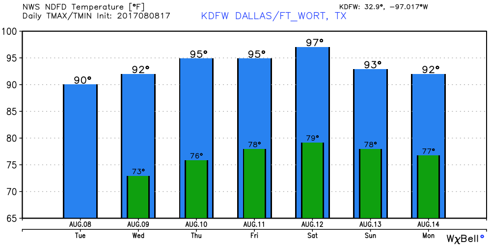 Tropical Storm Franklin is Inland Now - Tropical Storm is Island in the southern tip of Mexico with maximum sustained winds at 40 mph, and is expected to come through the island of Campeche tonight before going back into water temporarily, where some intensification is possible. After that, it will make second landfall over the Mexican coast, staying well to the south of Brownsville, Texas. There is still the chance that this becomes the first hurricane in the Atlantic. 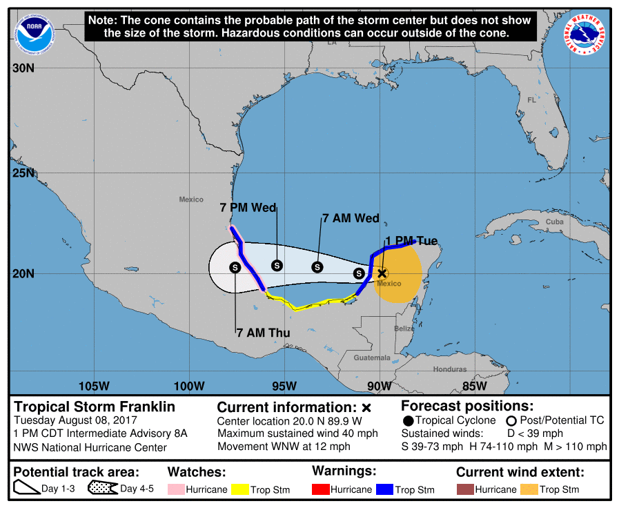 There is another tropical wave in the middle of the Atlantic Basin, which is fighting a lot of dry air and a lot of shear, which is heading northwest. There is a likely probability that this does not develop.
-Donovan Neal- |
Archives
March 2023
Categories |
 RSS Feed
