
|
STORMY WEATHER PATTERN - First off all, severe weather threats like this are VERY normal in the south in November and December, as these are our common late severe weather season months. There is absolutely no need to be fearful of this thing, just be prepared. Knowledge is absolutely imperative in these weather situations and hopefully this post will inform you of what you need to know. AFTERNOON/EVENING - The SPC now has the "enhanced risk" (level 3 of 5) of severe storms around the Interstate 35/45 corridor surrounding the Austin, Waco, Round Rock, and College Station areas. The standard "slight risk" (level 2 of 5) of severe storms runs from Midland in West Texas through Shreveport in Louisiana. This does includes areas along and south of Interstate 20 in the DFW Metroplex, and is south enough to include the city of San Antonio. Lastly, the "marginal risk" (level 1 of 5) of severe storms surrounds the rest of the North Texas region as well as Houston, Lubbock, Amarillo, and surrounding areas. 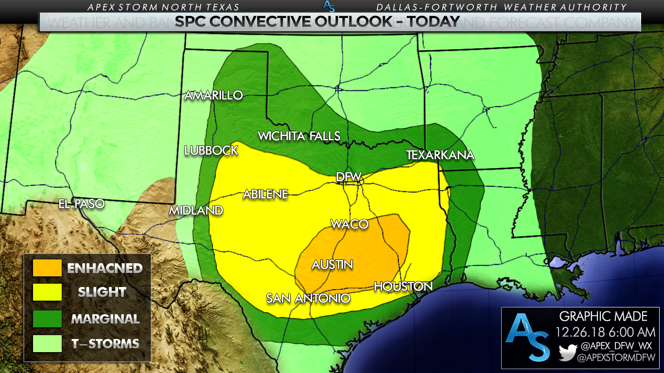 New model guidance this morning shows a relatively volatile setup this evening into the overnight hours; the combination of moderate instability, very strong directional shear, and strong backing of the winds are pushing the Significant Tornado Parameter (STP) up to a max of 10.6 over parts of South Texas this evening... 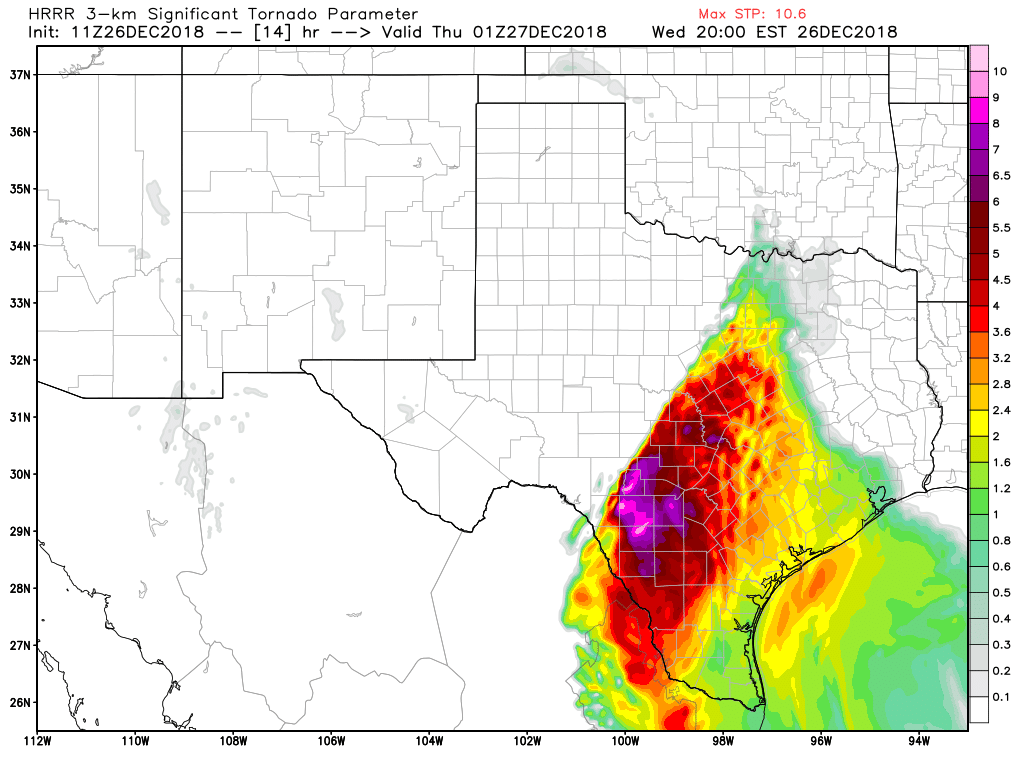 TIMING - Although scattered thunderstorms will be occurring through most of the day today, severe thunderstorm development will initiate at around 2:00 PM in West Texas gradually moving east, persisting through midnight tonight. A few storms could linger over East Texas tomorrow morning. THREATS - Storms this evening into the overnight hours could produce all modes of severe weather. Large hail (2" in diameter in the worse-case scenarios), damaging straight-line winds, and a few tornadoes can be expected. The highest tornado threat presides in the Enhanced Risk area near Austin. Based on the newest data this morning, I would not be surprised if we see one or two strong tornadoes, mainly in the enhanced risk area over Central Texas. If we see more discrete supercells before the sun goes down, the tornado and hail threat will be much higher from those cells. Eventually, storms will merge into a squall line later tonight, mainly posing a threat of damaging straight-line winds. A few brief spin up tornadoes are possible from that line as well. RAIN - Lots of rain can be expected from this storm system, and amounts of up to two and a half inches or greater can be expected for areas to the east of Interstate 35, which could pose a flash flooding risk in some spots. Lighter amounts of rainfall can be expected elsewhere, but still be aware because that will not mitigate the threat of localized flooding. 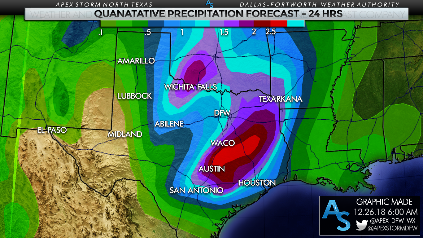 In the most flood-prone areas, the Weather Prediction Center has issued a Slight Risk of excessive rainfall which may lead to flooding at times.  OVERALL CONFIDENCE - The confidence in the potential of severe thunderstorm development is very high today, but there is still just a little bit of uncertainty as we will have scattered showers and thunderstorms that might impact atmospheric conditions this evening. We will be watching how far north the instability at the surface can make it, which will determine if we will have a localized "maximum" tornado potential. But most of the severe storms will come in a east-moving squall line with mainly damaging straight-line winds.
WILL THIS BE LIKE DECEMBER 26, 2015???? - I really don't like this question. December 26, 2015 had anonymously high instability values with support from strong wind shear and backing of the winds. While wind shear will be impressive today, instability will be lower with this threat of severe weather. Generally speaking, the event in 2015 was more of a 'once in a decade' type event. But remember, if there is only one tornado out of the entire state, and it happens to come down your street, that is your December 26th. PLAN OF ATTACK - During the day today is a good time to review and revise your tornado plan. -Make sure you can hear warnings today if they are issued. NEVER RELY ON AN OUTDOOR WARNING SIREN. IF THAT IS OUR MAIN SOURCE OF HEARING WEATHER WARNINGS, YOU HAVE NO HOPE OF HEARING THEM INDOORS WHEN IT IS NOISY OR WHEN YOU ARE ASLEEP. It is wise to have a NOAA Weather Radio in your home or place of work. Moreover, having a good smart phone app like this one will serve you well if you typically get weather information from your phone. -Know the safe place in home. This is typically a small room on the lowest floor near the center of your house, away from windows if you don't have a basement, safe room, or storm cellar. If you are in a mobile home in a tornado warning, you must leave and go to a shelter or a sturdy building. -In the safe place in your home, it is wise to have a helmet for everyone in your family to wear. It is also wise to have a portable air horn to get the attention of first responders if you need help. Lastly, be sure to wear hard sole shoes because in the worse-case scenario, you don't want to talk over a debris field with bare feet or socks. Me and Jonathan Williams will be on social media throughout the day answering questions, and updating the current situation. Stay tuned for updates! |
Archives
March 2023
Categories |
 RSS Feed
