
|
EVEN COLDER - This morning features very cold temperatures in the upper 20s to low to mid 30s across the region. With the cold front coming through yesterday, look for mostly cold days and chilly nights with highs in the 45-55 degree range with morning lows in the 30 degree range. It must be noted that the average high for DFW is 60. Morning lows will mostly be above freezing for much of the region, but it will still be pretty cold each morning through Thursday. Clouds will increase tomorrow in advance of a developing storm system to the west, and rain could reach the region very early Friday morning. COLD, WET START TO THE WEEKEND - A surface low is forecast to move along South Texas, setting up a good cold, soaking rain for much of the state on Friday and Friday night. Temperatures will be in the low to mid 40s over North Texas. Rain amounts of two and a half inches are likely over the region, and yes, it will pretty much be an all day type of rain if you are planning something outside. The surface low will move east into the Gulf Coast on Saturday, but global model are beginning to indicate more moisture from the back side of the system. This would mean that Saturday would be another wet and cold day. Highs will be in the upper 30s to low 40s regardless of precipitation. We should mention that snow/ice issues are likely over a good part of the Texas Panhandle, Oklahoma, Arkansas, and Tennessee during the day with this system, so be cautious if you are traveling to the north. The low will continue to move to the east, but global models are starting to indicate the potential of a few snowflakes/very light accumulation parts of West Texas into the western counties of North Texas very early Saturday morning. It is way too early to understand any impacts, just something to watch. The main significant snow/ice issues should be to the north and northwest of North Texas. NEXT WEEK - Monday will feature decreasing clouds, but the rest of the week looks mostly dry and sunny with slowly moderating temperatures... See the Texas Weather Discussion Video for more details. 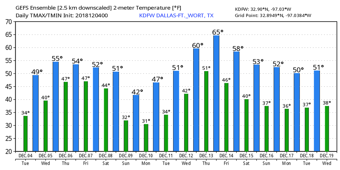 |
Archives
March 2023
Categories |
 RSS Feed
