
|
Cool Start - Temperatures on this Halloween morning are actually very similar to yesterday's lows; most locations start out in the 50s, with some of the naturally cooler spots in the 40s. As a result of the cold front that came through yesterday afternoon, we should experience much cooler highs with the temperature only warming 6 to 8 degrees today. A cool day is in place. In addition to the cool air, scattered showers and storms will be possible during the afternoon/evening hours. Most models have the idea that the bulk of the rain will enter DFW at around 4:00, before exiting the area after 7:00. Model guidance also back off the amount of rain associated with this feature, but, you will still need to bring an umbrella just in case anything decides to stick out after the bulk has passed. Tomorrow through Friday - After Wednesday, we start the rapid increase in temperatures with highs ranging from 83-89 degrees. All of us should stay dry from any rainfall, which should also be perfect for the high school football games. The Weekend - Not much change; we maintain fairly consistent weather with cloudy period along with highs in the mid 80s. Most communities in DFW stay dry. Next Week - Another cold front comes through early next week, which will bring the chances for cooler temperatures and scattered showers and storms. More details we get closer. 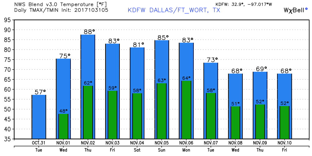 Tropics - The disturbance located in the Central Atlantic is not expected to develop due to strong winds and shear. The rest of the Atlantic Basin remains quiet. Keep in mind that hurricane season runs all the way through November 31. We also begin our late severe weather season tomorrow. See the Texas Weather Discussion Video for more details.
|
Archives
March 2023
Categories |
 RSS Feed
