
|
TYPICAL JULY WEATHER: Overall moisture levels remain the highest they have been in about three years. So, we will continue to roll with a persistent forecast this afternoon through Friday. Partly to mostly cloudy skies, hot, humid, with the chance of isolated, mostly afternoon and evening showers and thunderstorms. Highs will be in the 93-98° range, with heat indices continuing to be in the 105-110° range. As such, a Heat Advisory remains in effect for much of the coverage area today. 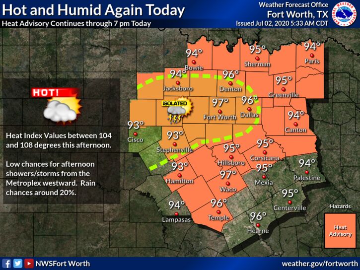 FOURTH OF JULY WEEKEND: The main westerly winds aloft (aka jet stream) will remain far to the north, and fairly typical July weather will continue across North Texas through Sunday. Partly to mostly cloudy, hot, and humid, with the chance of isolated to scattered, mostly afternoon and evening showers and thunderstorms. Most of the thunderstorms (not necessarily all) will form around 12:00-8:00PM, and the odds of any one spots getting wet is about one in three. No exact way of knowing where and when they form, you just have to pay attention to radar trends if you have any outdoor activities. Afternoon highs will be in the upper 90s.
NEXT WEEK: No real change in the forecast next week. Hot, humid summer weather will continue with the daily chance of "isolated, mostly afternoon and evening showers and storms". No way of knowing where and when they form in advance. Highs will be in the mid to upper 90s throughout the week. TROPICS: The Atlantic Basin remains quiet, and tropical storm formation is not expected through the weekend. ON THIS DATE IN 2001: In Michigan, frost and freezing temperatures were observed in some locations with Grant dropping to 29 degrees. Muskegon reported their coldest July temperature on record with 39 degrees. Other daily record lows included: Lansing: 38, Muskegon: 39, Flint: 40, Youngstown, Ohio: 40, and Grand Rapids, Michigan: 43 degrees. Look for the next blog update tomorrow at around 5PM.... Enjoy the day! Donovan Neal Owner - ApexStorm |
Archives
March 2023
Categories |
 RSS Feed
