
|
VERY HOT LATER TODAY: The remnants of Barry will continue to lift to the northeast, and the upper high from the southeast will take over, making for very hot conditions for the next several days. A Heat Advisory is in effect for much of the metroplex this afternoon through tomorrow evening for heat indices in the 105-110° range. Highs will be in the upper 90s with mostly sunny skies. REST OF THE WEEKEND THROUGH THE WEEKEND: Not much change. Each day will feature mostly sunny skies, hot conditions, highs in the upper 90s. A few clouds will remain possible, but showers and storms will be extremely limited as the upper high is still on top of us. NEXT WEEK: A surface front slips into the region Monday, and we could see a few isolated storms Monday and Tuesday. Other than that, expect mostly dry and hot conditions with highs continuing in the mid to upper 90s for most of the week. See the Texas Weather Discussion Video for more details. 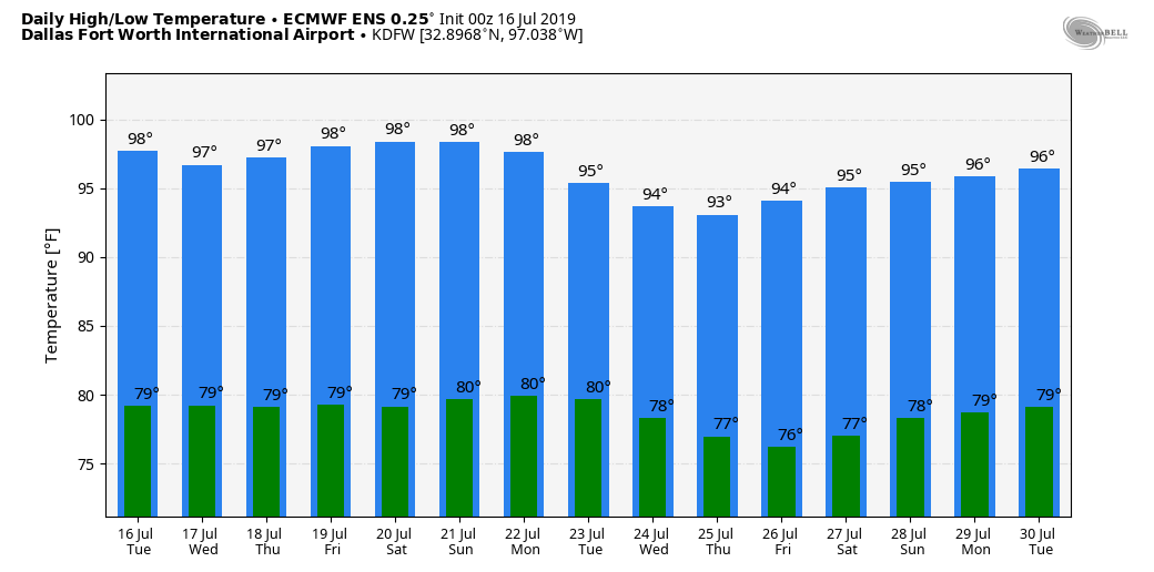 TROPICS: The remnants of Barry will continue moving to the northeast towards the North Atlantic. The rest of the Atlantic Basin remains quiet.
|
Archives
March 2023
Categories |
 RSS Feed
