
|
RADAR CHECK: Scattered showers and storms are continuing to develop in West Texas and are moving east this afternoon. Only thing to be concerned with is frequent lightning at times and gusty winds. There is no way of determining exact start/stop times of storms because of the scattered nature and small scale features. Just make sure to keep a close eye on the radar if you are outside. If you don't see rain, expect a mix of sun and clouds with hot and humid conditions. Highs will be in the upper 90s this week with heat indicies in the triple digits. REST OF THE WEEK THROUGH NEXT WEEK: To be completely honest with you, we have reached the time of the year where the weather doesn't change much at all. Each day will feature sunshine with some clouds around, humid conditions, daily hidden chances of "isolated, mostly afternoon and evening showers and storm(s)" with highs in the upper 90s. There will be no way in determining exactly where and when the storms form because of small scale features that not even the mesoscale models can resolve. Heat indices will be in the 100-107 degree range each day. See the Texas Weather Discussion Video for more details. 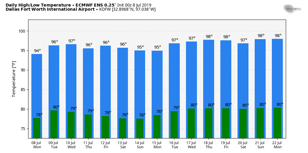 TROPICS: There is a broad low over the Gulf of Mexico that has a high (80%) chance of becoming a tropical depression within the next five days. What we don't know is where the system will end up. Some of the global models have hinted the system moving west towards the Texas/Louisiana Coast. More are starting to pick up on that idea. One way or another, expect heavy rain where the system does move into land. The rest of the Atlantic Basin remains quiet.  |
Archives
March 2023
Categories |
 RSS Feed
