
|
DRY MORNING - Temperatures are mostly in the upper 40s to low 50s this morning with a mostly clear sky. We will continue with a mostly dry day with a mix of sun and clouds as we enter a zonal flow here. Highs will be in the low to mid 60s today and tomorrow. MIDWEEK - Moisture from the remnants of Wilma in the Gulf will continue to slowly move eastward, bring widespread showers and thunderstorms to the state on Wednesday. Everyone will have a fair game in some rain at times, and temperatures will be in the mid to upper 50s with a mostly cloudy sky. Some morning leftover rain will be possible Thursday morning, clearing out by the afternoon to a mix of sun and clouds. Thursday and Friday look mostly dry with highs in the low to mid 60s. THE WEEKEND - Not much change. With an upper high in Central Texas, we will continue to mention sunny, fall-like weather with afternoon highs in the low 70s with morning lows in the mid 50s, that's still about 5 to 7 degrees below our average high of 77. NEXT WEEK - The early part of next week looks mostly dry and sunny with highs mostly in the mid 70s. As we transition into Wednesday, model guidance now shows a strong front carrying at least some chances of scattered showers and storms during the afternoon with highs in the low 60s. Other solutions showed 70 degrees as afternoon highs. The bottom line is - we don't know yet. It is still too far out to pinpoint any specific details regarding temperatures or precipitation chances for Halloween. See the Texas Weather Discussion Video for more details. 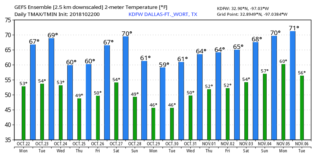 TROPICS - All is quiet in the Atlantic Basin, and no new tropical cyclones are expected to form for the next week. The 2018 Atlantic Hurricane Season ends on November 31.
|
Archives
March 2023
Categories |
 RSS Feed
