
|
COOL AIR - We are starting the day with temperatures down in the upper 50s/low 60s for most communities in North Texas. Today will feature mostly cloudy skies with scattered showers and thunderstorm chances all day. The best chance of a spot getting wet is in the 40/50 percent range at this time. Many places will struggle to reach 70 degrees today, but overnight lows will be in the low 60s again. THE WEEKEND - Our weather for the weekend will be dependent on how Tropical Storm Sergio behaves once it reaches North Texas. Right now, Sergio looks like it will brings tons of moisture to North and Central Texas on Saturday, which will mean widespread scattered showers and thunderstorms is starting to look more likely for the weekend, mainly on Saturday. Most communities will get wet during the weekend, and rain amounts will be in the 3-4 inch range for most of North Texas, which also raises the concern for flash flooding, especially on Saturday. The remnant low dissipates on Sunday, but we could still tap on some moisture for a few scattered showers. The best chance of a spot getting wet is 30 percent on Sunday. Highs will stay in the middle 60s for both days. NEXT WEEK - Another disturbance moves down from the north early Monday morning, bringing more chances of widespread showers and thunderstorms and maybe even the potential for winter precipitation for the Texas Panhandle. Monday looks like a cold, raw, muggy day with highs only reaching the low 50s, though global models only show most of North Texas in the middle to upper 40s by the afternoon. The rain lingers through Tuesday, which will be another raw, muggy day with highs only in the low to mid 50s by the afternoon. Flooding could be a concern again as an additional 2-3 inches of rainfall is expected through Wednesday morning. We trend dry for the latter half of the week as we warm to the middle to upper 60s with partly to mostly sunny skies. See the Texas Weather Discussion Video for more details. 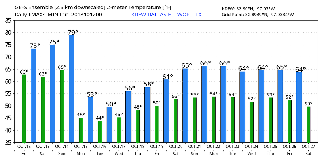 TROPICS - Michael is now a post-tropical cyclone, moving away from the US. Hurricane Leslie and Tropical Storm Nadine are in the eastern Atlantic posing no threat to land. A disturbance in the Caribbean will move into Central America in coming days. The NHC only gives it a 20 percent chance of developing over the next five days. 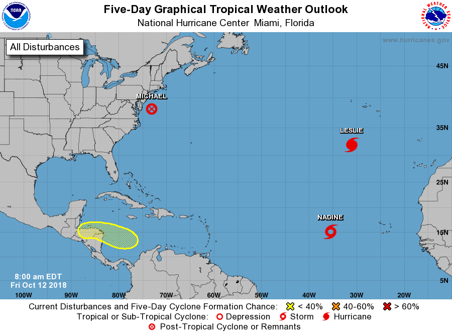 |
Archives
March 2023
Categories |
 RSS Feed
