
|
RADAR CHECK - Cold rain continues over much of the North/Central Texas area this morning.  Widespread rain will continue moving northeast over the course of the day. A Flash Flood Watch remains in effect until 7PM this evening, and additional rainfall amounts of 1-4 inches will be possible over North Texas over the remainder of this week. Temperatures are currently in the low to mid 40s now with the wind chill in the mid 30s. We will likely stay there as the rain does not go away anytime soon today. WEDNESDAY THROUGH FRIDAY - Rain will continue through the morning hours before decreasing in coverage during the afternoon and evening. We will be slightly warmer as temperatures will warm to the low to mid 50s during the afternoon on Wednesday. Confidence is increasing that a good chunk of Thursday morning will be dry with temperatures in the 50s, but more rain will move in during the afternoon hours and persist overnight through Friday. The good news is that the widespread coverage does not appear that likely at this present time, but is not out of the question. Temperatures will stay just at or below the 60 degree mark for Thursday and Friday. THE WEEKEND - An upper high builds in the Central Plains, pushing a new surge of drier air into the region. We will stay mostly cloudy though with highs in the low to mid 60s for Saturday and Sunday. Occasional showers and thunderstorms are not completely out of the question. NEXT WEEK - For now, the early part of next week looks dry with a mix of sun and clouds with highs in the mid 60s. A few showers could move in from the south during the latter half of the week, but a majority of the week looks partly to mostly cloudy and dry. See the Texas Weather Discussion Video for more details. 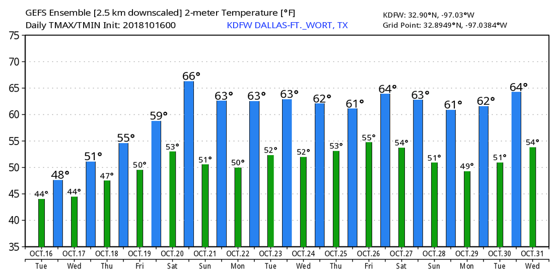 TROPICS - There is a disturbance near the Yucatan Penisula that will travel inland towards Central America. The rest of the Atlantic Basin and the Gulf of Mexico remains quiet.
|
Archives
March 2023
Categories |
 RSS Feed
