
|
WARM MORNING: Temperatures have not fallen much from yesterday, and are still mostly holding in the low to mid 70s this morning. There's a good chance we stay cloudy for the majority of the day, and we will only warm 10 to 15 degrees this afternoon as a result. ANOTHER ROUND OF SEVERE STORMS POSSIBLE THIS AFTERNOON: After dealing with some severe weather in North Texas yesterday evening that produced a couple brief tornadoes in Tarrant/Denton counties, we are expecting round #2 of severe weather this week to kick off the month of our peak severe weather season here in the Plains. The Storm Prediction Center has added an "enhanced risk" (level 3/5) of severe storms from Big Spring in West Texas to areas in and surrounding the DFW metroplex. The standard "slight risk" surrounds the areas outside of the metroplex such as Canton, Waco, Tyler, Texarkana, etc. 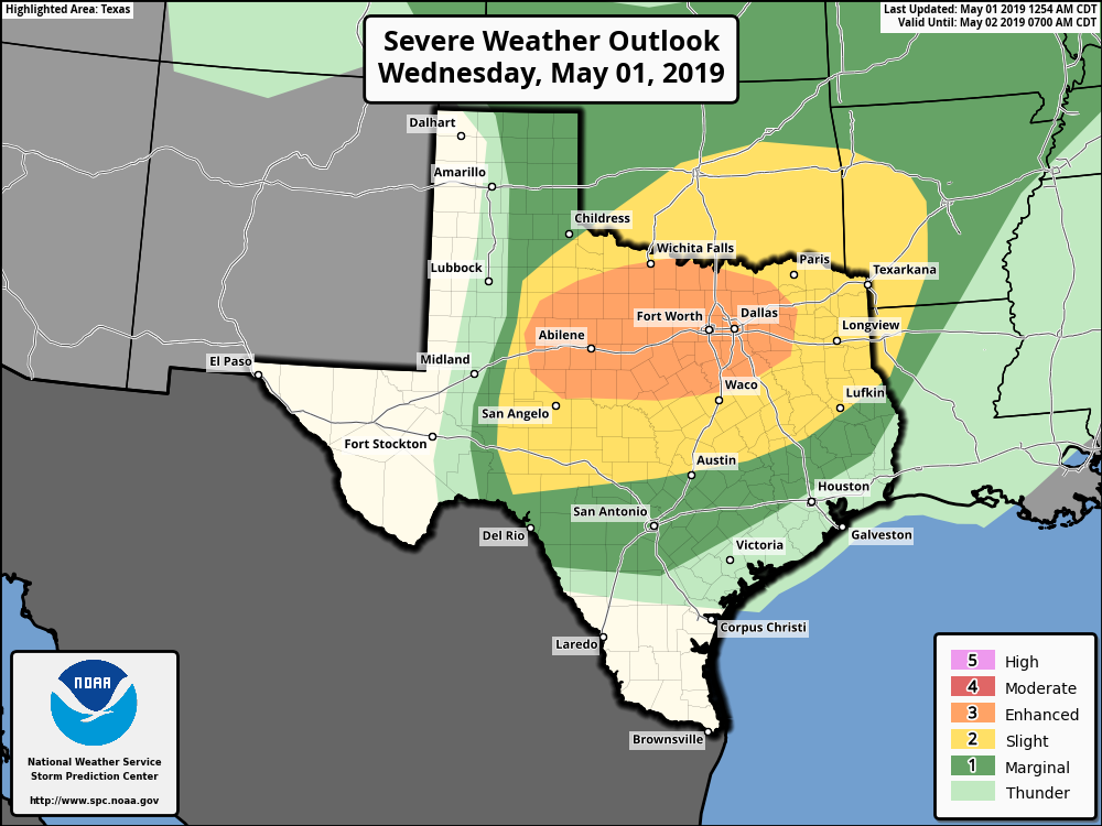 TIMING: Severe thunderstorms will develop in the late afternoon after 2PM in West and East Texas. They will encroach towards the metroplex over time, before impacting us during the evening and overnight hours. I expect the main action for our area at around 4-7PM. THREATS: These storms will have the capability of producing not only damaging winds, but large hail as well. The hail threat is just as equal as the damaging wind threat, considering how North Texas is notorious for seeing some of the most significant hail events. Just like yesterday, we could see a couple of brief tornadoes in the mix as well. RAIN: Another threat this afternoon and evening for everyone is heavy rain. Downpours are likely for those that experience severe thunderstorms this evening. Rainfall amounts of 2-3 inches are possible with isolated 4" likely. Flooding will become a concern for areas that not only see multiple storms, but for areas that received heavy rain yesterday. To address this, the NWS has issued a Flash Flood Watch for the Greater DFW Metroplex and areas to the North.  We are basically in the peak of severe weather season, and these type of threats are very common. However, it is imperative that you know where to go when threatened by severe weather. Some great severe weather safety tips can be found here. Also, you must ensure that your devices are charged, and you have a way of receiving warnings. That can also be found in the direct link above. Most of the severe weather could come during rush hour, so getting home a bit early won't hurt today. But most importantly, DO NOT PARK UNDER HIGHWAY OVERPASSES. THEY OFFER NO PROTECTION FROM SEVERE WEATHER AND CAN PUT LIVES AT RISK BY BLOCKING ANY ONCOMING TRAFFIC.
We will repeat this process again on Thursday, with another risk of severe weather for much of North and Central Texas this time. With lower wind shear values, we will have more of a large hail and damaging wind threat. Just like the past few days, we would like to get through today's severe weather threat before we focus on tomorrow's. |
Archives
March 2023
Categories |
 RSS Feed
