
|
A TYPICAL SPRING DAY: Temperatures in the mid to upper 60s in the morning, a mix of sun and clouds in the afternoon, temperatures in the low 80s with at least some chance of isolated showers and storms in the afternoon and evening hours - it must be spring in North Texas. Any storms we see will tend to be isolated in nature, and most spots will not see rain today. Some storms could be on the stronger side and may try to produce some hail and gusty winds in some spots. 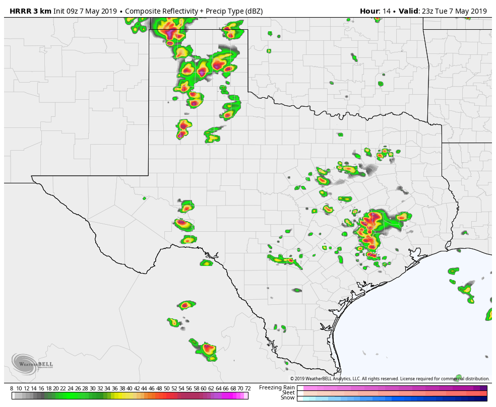 NOT AN ACTUAL FORECAST!!! While we enjoy just a few innocent rain showers in some spots, an active severe weather day is expected over parts of the Southern Plains down into West Texas. There is a "moderate risk" (4/5) of severe storms today for parts of the Texas Panhandle into extreme West Oklahoma. 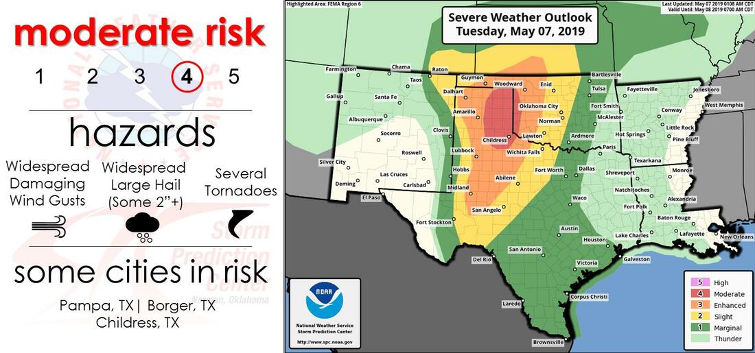 TOMORROW: There still lies many questions about tomorrow, and there are many factors to key into play. But for now, the Storm Prediction Center has areas to the east and south of the greater DFW Metroplex under the "enhanced risk" of severe storms (3/5) tomorrow, while DFW and surrounding areas retain the standard "slight risk" of severe storms (2/5). 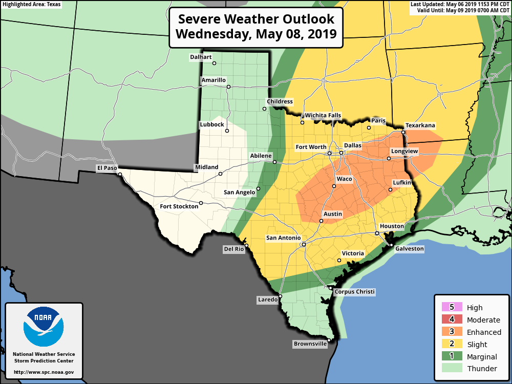 MORNING ROUND OF SEVERE WEDNESDAY: Using what Logan talked about in yesterday's blog, we should know that there are many scenarios that may go into tomorrow. Right now, our current thinking is that a line of strong to severe storms will roll through the North and Central Texas area during the morning rush hour and continue to move to the southeast with time. If this were to happen, the main thing we would have to deal with is strong, damaging wind gusts from the line in this morning, as the atmosphere would have already regained stability in the afternoon and evening, precluding any greater threat of severe storms in the evening. 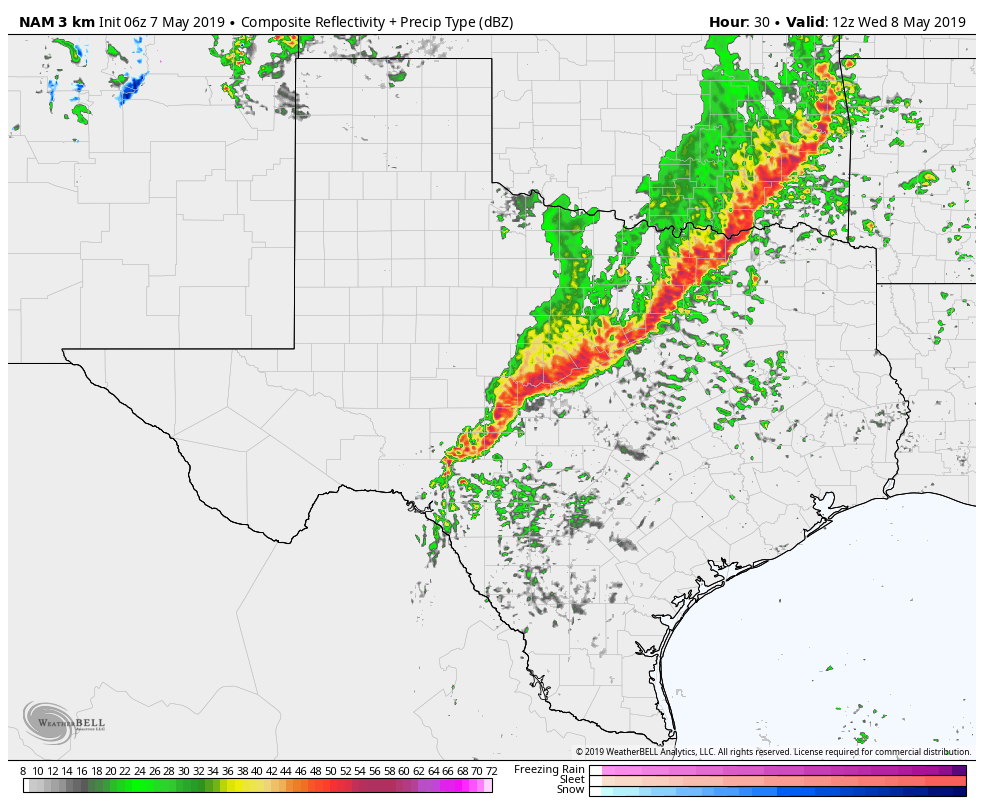 NOT AN ACTUAL FORECAST!!! However, keep in mind that there is the chance that a) the line of storms stay to the north in Oklahoma and doesn't affect North Texas or b) the line doesn't develop at all. If any of those scenarios happen, North Texas would be at a higher risk of severe storms in the afternoon and evening, which would ultimately be more of a hail and tornado risk at that point. As you can see, this is a very low confidence forecast with so many "if" factors coming into fruition. But one thing we can be certain of is North Texas seeing some type of severe weather tomorrow; we just don't know when. Therefore, it is imperative that you stick to the latest forecasts and make sure you have emergency alerts enabled on your phone. Moreover, every home and business should have a NOAA Weather Radio. THURSDAY: After the severe weather has passed, expect a mixture of sun and clouds throughout the day with highs in the low 80s, very seasonal for May in North Texas. FRIDAY AND THE WEEKEND: The cold front bringing severe storms to the southern plains will stall out around here for Friday and Saturday, so we will need to keep the chance of showers and storms in the forecast on Friday and Saturday. No severe weather threat on any of those days, and it will not rain all day. The high will be in the 70-75 degree range for the weekend. Sunday will feature a mix of sun and clouds. NEXT WEEK: The early part of next week looks a little wet with isolated showers possible on Monday and Tuesday. Otherwise, expect very seasonal conditions throughout the week. See the Texas Weather Discussion Video for more details.  Me and Logan are busy preparing graphics and setups to provide you with the most accurate and visually pleasing forecasts in the Dallas/Fort Worth Metroplex! Be sure to stay tuned for later updates!
I will have my next blog post (weather permitting) tomorrow morning at 7AM! Enjoy the day! Donovan Neal |
Archives
March 2023
Categories |
 RSS Feed
