
|
CALM BEFORE THE STORM: As forecast, temperatures are already in the middle 70s across North Texas this morning, which are high temperatures you would typically see on a good spring day. Like I said in the video, when temperatures are that high this early, you already know days like this will be pretty bad for some. Due to an abundance of moisture, some fog is possible in some communities this morning. Today will also be particularly windy, and a Wind Advisory is in effect for all of the North Texas region today. We will be in the upper 80s today. TORNADO OUTBREAK EXPECTED ACROSS NW TEXAS AND OKLAHOMA: The large scale features is indicative of a classic Plains tornado outbreak scenario across Oklahoma and Northwest Texas. A surface low that's on the Colorado, NM border will also be supported by a deep upper trough and strong shearing. Forecast surface based CAPE values (instability measure) are expected to soar into the 4,000-6,000 j/kg range, making for a "powder keg" and a "loaded gun" situation by the afternoon hours. The SPC has placed parts of NW Texas and much of Western Oklahoma in a very rare "High Risk" (level 5/5) of severe weather. This is the first high risk day since May 2017 and only the third time a high risk has been issued under the five tier categorical outlook system. Usually a high risk is issued when there is great confidence of a major severe weather and/or tornado outbreak for that zone. That is what we are seeing this morning... 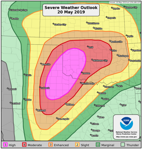 Although there is the high risk in place, I advise you to not get caught up in looking at these risk maps as this is just simply a guideline; storms do not read these maps and certainly don't know where these exact lines are. Just realize that all of the Southern Plains is at a significant risk of a major tornado outbreak this afternoon and evening. TIMING/THREATS: There will be multiple waves of storms and severe weather throughout the day. The primary threat with the ongoing morning storms out in the Texas Panhandle currently is hail and strong, gusty winds. Storms from around 12PM to 12 AM Tuesday morning will be capable of producing very large hail, very damaging winds, and the potential for violent, long-track tornadoes, especially in the High and Moderate risk zones. RAIN: Heavy rain will be the second biggest threat today across Central Oklahoma, and rainfall amounts anywhere from 2-9" with locally higher amounts are likely. Flash Flood Watch is in effect for most of the Oklahoma state. CALL TO ACTION: Right now, make sure you have a way of receiving warnings at a moments notice, NOAA weather radio is the baseline, but a good smartphone app is the next level of prepardness. Identify your safe place in your home or business, and ensure everyone knows where it is. In that safe place, make sure you have helmets and hard-sole shoes for everyone, and a whistle and portable airhorn in case you need help. A full detailed list of severe weather safety information can be found here. TAKE ONE DEEP BREATH: This is the peak of spring tornado season here in the plains, and severe weather threats are very common here, nothing unusual like today. However, we have had a quiet 3-5 years compared to years past, and we all knew it couldn't stay quiet forever... just make sure you have a way of receiving warnings, have a plan of action, and prepare a good readiness kit in your safe place and you will ride this outbreak out just fine. Also, keep in mind that there is always the potential that this outbreak could "bust", which is best described as a situation where storms are not as severe as forecast. Be advised that it takes multiple factors to come together in one place and time for tornadoes to develop. REST OF THE WEEK FOR NORTH TEXAS: North Texas will continue mentioning mostly dry weather for the next week. Some storms are possible tomorrow morning, but most of the week will feature mostly sunny skies and a few clouds with highs in the upper 80s. THE WEEKEND: Not much change, the weekend will feature seasonal temperatures with mostly sunny skies. Highs will be in the mid 80s. NEXT WEEK: Not much change, seasonal temperatures will continue along with sunshine and smiles. See the Texas Weather Discussion Video for more details. 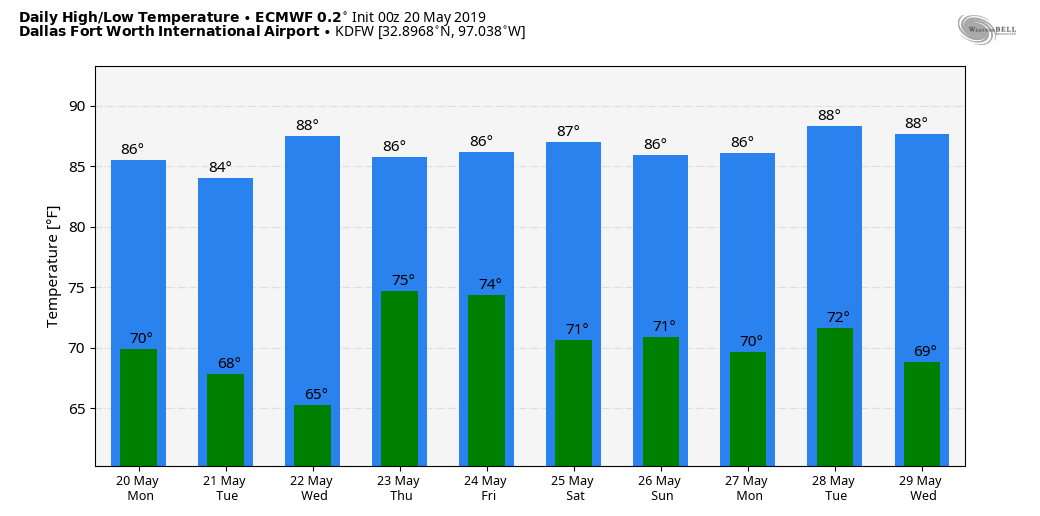 ON THIS DAY IN 2013: A large and extremely violent EF-5 tornado tore through parts of Moore, Oklahoma and adjacent areas, with peak winds estimated at around 210 mph, killing 24 people and injuring 212 others. This was the latest EF5 tornado recorded in the US, and that part of Oklahoma has a risk of violent tornadoes today.
|
Archives
March 2023
Categories |
 RSS Feed
