
|
TODAY - A warm front is exiting most of Texas this morning. For North Texas, that means skies will remain generally cloudy with isolated to perhaps scattered showers throughout the day, mainly during the afternoon. It will not be a complete washout, but, just keep a close eye on the radar for rain at times. A few rumbles of thunder is possible, but no severe weather issues today. The Storm Prediction Center has removed the marginal risk for parts of North Texas today. Highs will be in the upper 60s to lower 70s. TOMORROW - The old front will exit Texas, and a new, stronger front will begin moving through the region during the morning. Showers will be ongoing for parts of Northeast Texas, eventually spreading to the southeast throughout the day. Most communities will stay dry in the morning, but isolated to scattered showers will increase through the afternoon. Just like Saturday; not a widespread event, but just rain at times. Some storms may produce some thunder, and some of the stronger storms may pose a threat for hail and gusty winds. Highs in the mid to upper 60s. MONDAY - Widespread showers and storms are possible especially during the pre-dawn hours and through most of the afternoon. The cold front will have exited the region by now. Rain will eventually taper off in the evening. No severe weather is expected and afternoon highs will be in the mid 50s due to rain cooled air. TUESDAY - The activity will have finally moved out of the region by early Tuesday morning, which should lead to most of the day being dry, although mostly to partly cloudy. A stray shower or two is never out of the question. Highs will be in the upper 50s/low 60s across the area. WEDNESDAY - The chance of us seeing some sunshine during the day is much greater on Wednesday as we start to dry out now that the shower and thunderstorm activity is out of North Texas. Skies will be mostly sunny with highs in the upper 60s. THURSDAY - A surface low looks to form over the Texas Panhandle during the day that will be moving in our direction throughout the evening. While most of the day will feature a mix of sun and clouds with highs in the upper 60s to low 70s, I can not forget the potential for isolated showers Thursday night and Friday morning as the low rotates through our area. FRIDAY - The low quickly rotates out of our area, and we should be completely dry by daybreak. Another pleasant, spring-like day is expected with highs in the mid to upper 60s across the region. 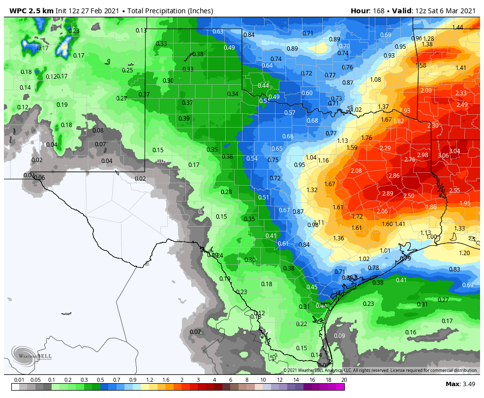 PROJECTED RAINFALL AMOUNTS - We can expect a decent amount of rainfall over the week ahead as the WPC is projecting anywhere from .5-2" of rain for much of North Texas.
Donovan Neal Owner - ApexStorm |
Archives
March 2023
Categories |
 RSS Feed
