
|
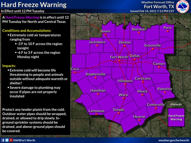
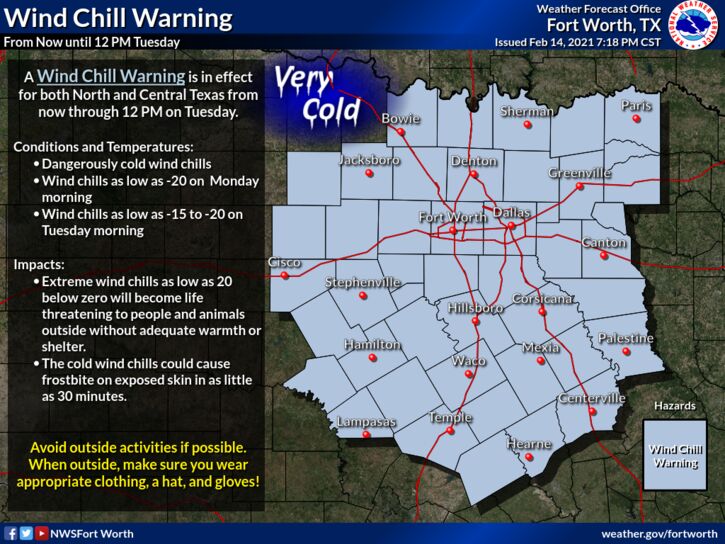
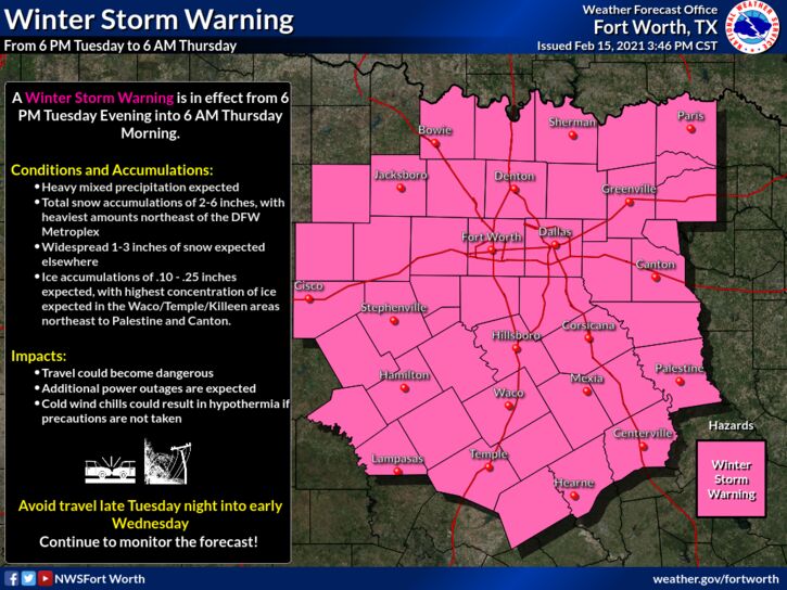
Another surge of arctic air is expected over most of the region overnight, which will create the coldest airmass North Texas has seen since 1989, despite us seeing that type of cold this morning. The NBM (National Blend of Models) currently has all of the region at zero degrees, with several places reaching below zero Tuesday morning... 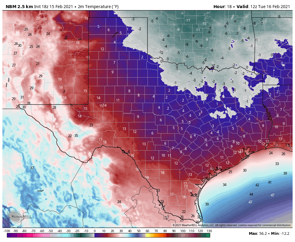 This will allow all of the snow and ice we saw yesterday to continue to stay in place for another day, making travel extremely difficult to nearly impossible throughout the day. I expect the demand to be the same for power across the state, so I don't see any improvements to the power situation across Texas anytime soon. As of 8:08 PM, 4,363,283 Texans are without power right now... 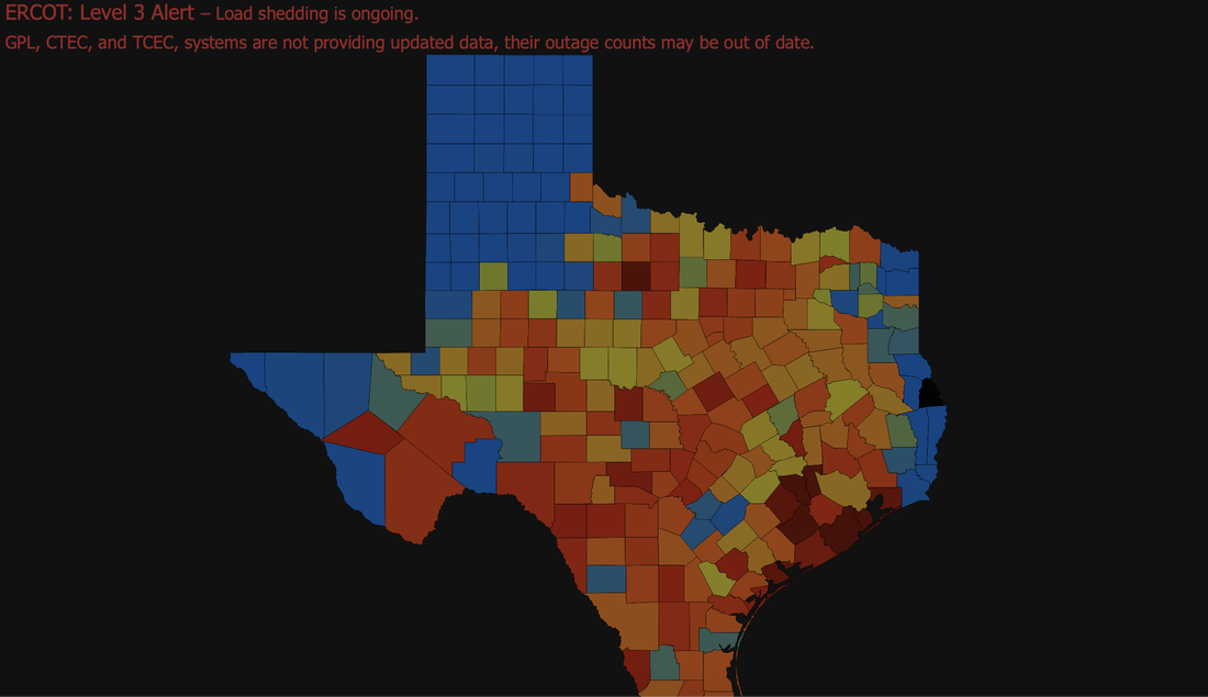 I wish I had good news to share with you all, other than the fact that the sunshine did help just a tad, but not enough to make a difference because of the frigid temperatures. I don't see any improvements on the roads unless they are plowed or until Thursday at the earliest very earliest. WINTER STORM #3 - Our last potent winter storm of this series will impact portions of North Texas, but mainly into East Texas tomorrow night into Wednesday with potential for enough snow and ice accumulation to continue major travel impacts and power outages into Thursday. WATCHES/WARNINGS - All of our North Texas counties are under three warnings... A Hard Freeze Warning is in effect for all counties in North Texas until 12:00 PM tomorrow. A Wind Chill Warning is in effect for all counties in North Texas until 12:00 PM tomorrow. A Winter Storm Warning is in effect for all counties in North Texas until 6AM Thursday morning.
PLACEMENT: The main impact will come in the Winter Storm Warning area. An additional 1-3 inches of snow is possible across the region, which the northwestern side of the region potentially seeing 2-4". For the southern 2/3's of our area, such Waco, Temple, Coriscana, etc., I expect most of your impacts to come in the form of freezing rain, some of which can be heavy at times. That will cause re-icing on most bridges, overpasses and roads. For now, expect another round of snow for all of North Texas, including the Dallas/Fort Worth Metroplex Tuesday evening through Wednesday. However, freezing rain and sleet will also be an issue along with the heavy to moderate snow at times. A change to freezing rain is a good possibility across DFW and points to the south and east as the system skirts eastward with time. Places like Corsicana, Tyler, and Palestine could see a half an inch or more of freezing rain with this event. Some freezing rain is possible as far north as the I35 Junction in Denton county. But again, for most of those in the Winter Storm Warning, it will mostly be snow, some sleet, and freezing rain, in that order. TIMING - The precipitation will come in two phases. The first round will come in a very small window late Tuesday night; light to moderate snow is possible for the northern 2/3rds of the region during that time. Amounts from that will be fairly light, but, it doesn't take much for places to re-ice again, especially since we are still below freezing. The main event will come at around or after midnight for much of North Texas where snow, sleet, and freezing rain will become heavier and more widespread across the winter storm warning area. Impossible travel conditions will continue across the region, and a final layer of ice on top of the snow that has already fallen, including on top of trees and power lines. Precipitation will be over by Thursday afternoon for most of the North Texas region. Roads across the region could remain icy and dangerous all the way through Friday, since temperatures will not reach above freezing until then, even with sunshine. IMPACTS - Not only will be looking at the potential for more heavy snow, but freezing rain and some sleet will be possible. Ice accumulation of .10" to .25" is likely, with additional .40" spots as well. Travel will remain difficult, if not impossible in many areas due to a fresh coating of ice on roads and surfaces. Rolling power outages are likely statewide. This will be a more impactful ice storm for areas to the south and east of the metroplex. 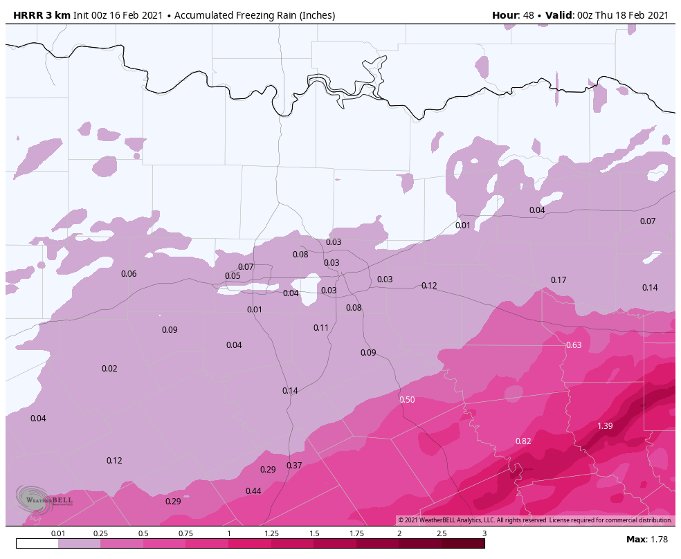 REMEMBER: When we release a snowfall map tomorrow, the boundaries won't be in straight lines like the maps we show you; they are simply used as a guideline. But understand that some places in the winter storm warning will see little to no freezing rain and all snow, while others will see just freezing rain.
More forecast adjustments are possible tomorrow. If you are reading old information, you are working with bad information. PREPARE - Use tomorrow to prepare as much as you can around the house... *Be sure all of your phones, tablets, and other devices are fully charged. *Travel is highly discouraged. If you MUST travel, create an emergency supply kit for your car. Include jumper cables, sand, a flashlight, warm clothes, blankets, bottled water and non-perishable snacks. Keep a full tank of gas. Have cat litter or sand to help tires get traction, or road salt to melt ice. *Gather supplies in case you need to stay home for several days without power. Keep in mind each person’s specific needs, including medication. Remember the needs of your pets. Have extra batteries for radios and flashlights. *Turn your refrigerator and freezer to their coldest settings. *If you lose power and you plug a generator into the house electrical system, turn the main off in the breaker box. Otherwise it can be very dangerous for the crews working to restore power. *Understand some could be without power for more than 24 hours with very cold, sub-freezing temperatures. Have an alternative source of heat. And, use it safely. CONNECT - You can find me on all major social media networks... ApexStorm Text Messaging Join Link Donovan Neal Owner - ApexStorm |
Archives
March 2023
Categories |
 RSS Feed
