
|
LOCALLY: Early morning/afternoon showers and thunderstorms continue to lift to the northeast, out of the region. New development is expected by the late afternoon hours, with the severe threat beginning in our counties to the west by 3p. We will continue to reach for the low 70s later this afternoon. TEXAS SEVERE WEATHER THREAT: As expected, the risk of severe weather for a good chunk of North Texas has increased as the mesoscale model data becomes more refined as well as reaching realizations of our current atmospheric conditions. A potent storm system with very strong wind fields is advancing to the east, and will continue to do so through the weekend, interacting with a very unstable airmass across Texas and the Deep South. As the atmosphere destabilizes, long-track, dangerous supercells evolve where the cap erodes and will subsequently move very quickly to the east to the north-east, capable of producing strong to violent tornadoes, very large hail, and damaging winds, depending on where you are in the Deep South. Our afternoon/evening of severe weather will be today through the overnight hours for much of Texas. The greatest risk of severe weather will lie in West and Central Texas. The SPC (Storm Prediction Center) has issued an "enhanced risk" level (level 3 of 5) of severe storms from a broad line from Childress to San Antonio, followed by the standard "slight" risk (level 2 of 5) encompassing the rest of the state. 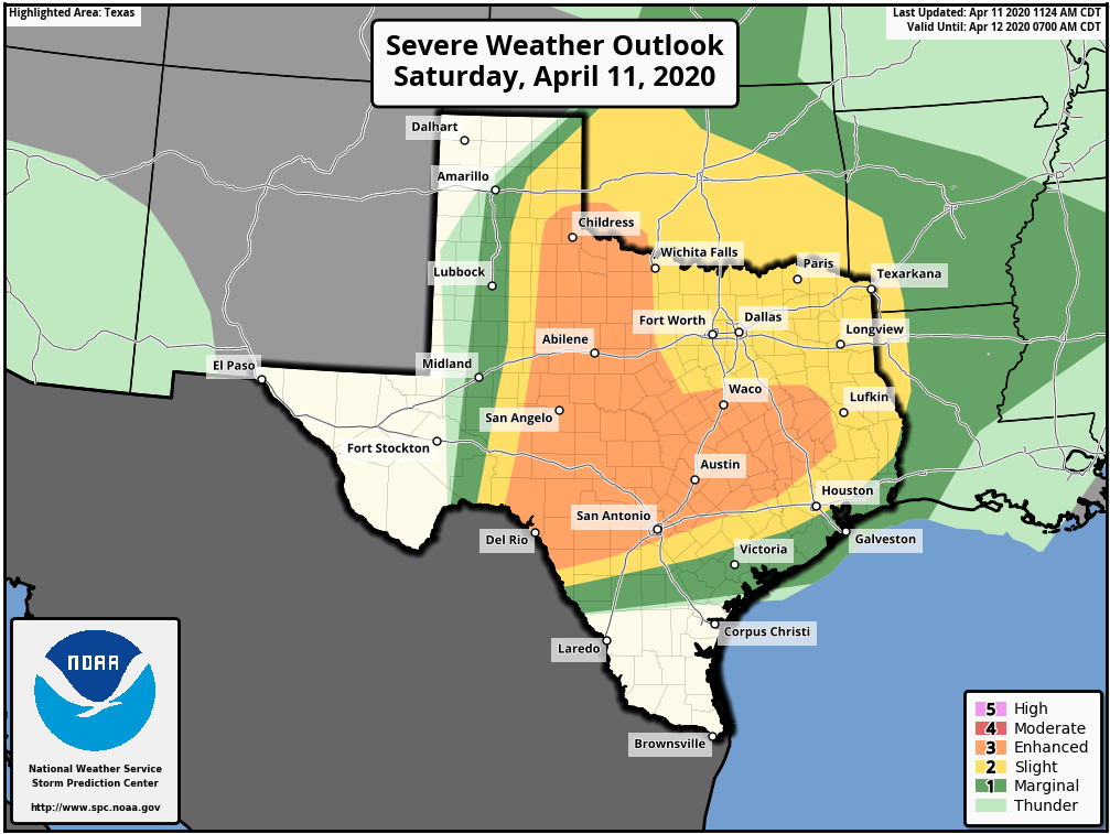 Continue to understand to understand it doesn't matter where you are in these colors. If you live in North or Central Texas, just understand that you have a chance of seeing severe weather this afternoon and evening into the overnight hours. Storms do not follow these guidelines that are used to illustrate where the best combination of thermodynamics and dynamics are. TIMING: Initial thunderstorm development will take place in Northwest Texas at around 3 to 4PM. These storms will move to the east-northeast with time, and the core threat of supercell thunderstorms will come during the evening to overnight hours, generally between 4PM and 12AM. Our last round of rain/severe thunderstorms will come from the Del Rio Valley, developing at around midnight, making its way into the North-Central Texas area from around 3 to 8 AM as the cold front moves to the east. THREATS: With the first round of supercell thunderstorms, all modes of severe weather will be possible, including primarily large hail, damaging winds, and a few tornadoes. Given the dynamics that are in place, while I don't anticipate widespread tornado reports, I do think there is *potential* for one or two intense tornadoes with the initial supercells that develop in Northwest Texas and move to the east. The threat with the pre-dawn QLCS (Quasi-linear convective system) will come from mainly damaging winds and (very) large hail in some spots. There is even the risk for a couple of embedded, brief tornadoes. RAIN: Rain amounts should generally stay below an inch for most places in North Texas, so flooding will not be of concern. Now, that we have covered this evening, let us shift the attention to our folks that may be affected in the Deep South. Please share this if you know anybody that might be in this area. The SPC maintains a "moderate risk" (level 4 out of 5) of severe weather for much of Central Louisiana, Mississippi, and parts of west and Central Alabama, with an "enhanced risk" (level 3 out of 5) encompassing much of the Deep South at this point.  TIMING: Initial thunderstorm development will take place in the Ark-La-Tex region late morning as unstable air shifts northward in advance of the warm front. The peak threat of supercell thunderstorms for the most affected region will take place from around 12PM to 12AM.
THREATS: All modes of severe weather will be possible, including the threat for very large hail and damaging winds. Based on the magnitude of the atmosphere, several tornadoes are expected, including the potential for a few violent, long track tornadoes. UNCERTAINTY: WIth any severe weather event, comes with the air of uncertainty that could either make for a worse-case scenario or for storms to not be as intense, which is ultimately what we want. Elevated convection within the warm sector is expected during the morning hours, which could dampen the overall severe potential, or produce enough outflow to introduce a higher-end tornado potential. This type of uncertainty precludes the need to upgrade to a high risk with this forecast at this present time. However, confidence is still high that a macro-scale severe weather event takes place. WiLl tHiS bE LiKE aPRiL 27tH, 2011?: I really do not like this question at all. 216 tornadoes were confirmed that day, with a third of them being strong to violent. Those are generational events. Meaning, they tend to happen once every 40 years or more. However, bear in mind that if there is only one tornado in your state, and that happens to come down your street, that is YOUR April 27th, 2011. PREPARE, PREPARE, PREPARE: Today is day where you and your family need to keep ready for severe thunderstorms. Be sure you have multiple ways of receiving warnings. NEVER RELY ON A TORNADO SIREN. First, make sure you have a NOAA Weather Radio. Every home in the Plains and Deep South needs one as they work off of their own network, making them very reliable. On your phone, make sure you have WEA (Wireless Emergency Alerts) enabled on your phone. To make sure of this go to Settings > Notifications > scroll all the way down to the bottom to ensure that "Emergency Alerts" are enabled. If you live in the North-Central Texas region, be sure to join our text messaging system by texting @apexstorm to 81010; it is an excellent way of getting severe weather watches and warnings pushed to your phone, as well as daily forecasts and forecast updates. Find the safest place in your home. It is typically in a small room, on the lowest floor, near the center of your house, away from windows. In that safe place, have helmets for everyone, airhorns (in case you are injured and need to alert first responders on site), and hard-sole shoes (if you must walk over tornado debris). If you live in a mobile home, you can not stay put during a tornado warning. Identify the nearest location of a shelter or safe place, and know how to get there at a moments notice. YOU'RE GONNA BE FINE: I am well aware that we are in a time in our society that most people in the South, and nationwide, are suffering from high anxiety from a global pandemic. The last thing we want as trusted forecasters is to add to that anxiety. However, at the same time, we must present the weather situation the way it currently stands. If you are located anywhere in the Deep South, just know that there is no reason to panic about today or tomorrow. Even during a severe weather outbreak, the chances of a tornado hitting your house are low, as tornadoes are tiny compared to counties, or the entire state. Unfortunately, lots of amateur weather weenies are on the social media outlets today using a myriad of scare tactics, which is ridiculous and irresponsible. They do not have any prior knowledge behind the different models and maps, what they mean, or how to interpret it. Yet, people will share them without second guessing. Please stay away from these pages, as nobody needs more anxiety. Only get weather information from trusted sources (like this blog and our social media outlets). COVID-19: From the National Weather Service offices in Alabama and Mississippi, the Alabama and Mississippi Department of Health: MISSISSIPPI: This spring, the Mississippi Emergency Management Agency (MEMA), the Mississippi State Department of Health, (MSDH), and the National Weather Service (NWS) are offering the following guidance for how to take shelter from severe weather during the COVID-19 pandemic. The need to practice social distancing and prevent the spread of COVID-19 brings added complications to taking shelter from severe weather. However, state and federal officials agree that your top priority should be to protect yourself from a potential tornado. Officials recommend sheltering from tornadoes inside your home when possible. If you don't have a below-ground storm shelter, well-constructed homes and buildings provide life-saving protection from many of Mississippi's tornadoes. Take shelter in a closet, bathroom, interior hallway or other interior room with no windows on the lowest level of the house or building. For mobile home residents, you should abandon the mobile home in favor of a sturdy building during severe weather. This alternative structure should be a part of a severe weather plan that is identified well in advance. If your family typically takes refuge in a public storm shelter in your community, first check with your community shelter managers to ensure they will still be open and if there are any special considerations to plan for due to COVID-19. Now is the time to explore the best options to keep you safe from severe weather as well as limit your exposure to the virus. Don't wait until a tornado warning is issued to make a plan. Wherever you choose to shelter from a tornado: take as many precautions as possible to inhibit the spread of COVID-19 as best as you can, continue social distancing, and frequent handwashing. The best way to prepare for severe weather during a pandemic is to stay informed of the latest weather forecast from the NWS and local media: as well as the latest recommendations regarding COVID-19 from the Center for Disease Control (CDC), the Mississippi State Department of Health, and local authorities. ALABAMA: The decision to seek shelter in a community storm shelter is certainly made more difficult by the consideration for COVID-19, and each individual will need to make an educated decision on where and when to shelter from a tornado. At this time, the Alabama Department of Public Health (ADPH) is recommending that your first priority should be to protect yourself from a potential tornado. If a warning is issued for your area, you are more likely to be affected by the tornado than the virus. However, the decisions to open any community shelters are done at the local or county level. Before you make a decision to go to a community shelter, you should check with your community shelter managers to ensure they are open, and if there are any local COVID-19 considerations. Certainly, wherever you choose to shelter from a tornado, you should use as many precautions as possible to inhibit the spread of COVID-19 as best as you can. If you rely on public community shelters, now may be the time to explore other options that might keep you safer from severe weather and possibly limit your exposure to COVID-19. Keep tabs on our feeds @donowx, @LoganShipleyWx, the blog, and join the ApexStorm text message system by texting @apexstorm to 81010. Just hang tight, we will get through this together. |
Archives
April 2024
Categories |
 RSS Feed