
|
SPRING-LIKE MORNING - It is starting to feel more like spring deep in the heart of Texas this morning. Temperatures are in the upper 60s to around 70s across the region, and today should be mostly cloudy and very windy, similar to yesterday. We will mention the chance of a stray shower or two, but not very likely and most places will stay dry. Highs will be in the low 80s. Tonight will be mostly overcast with lows in the upper 60s/low 70s again. REST OF THE WEEK - A upper-level trough will reach down to the southwestern part of the nation for most of the week, which means we will most likely see some sort of severe weather threat during the middle of the week. Despite a major severe weather threat three hours to the north of us, we forecast only a few scattered showers and storms on Wednesday with highs in the mid 80s. A few storms might end up turning severe, but that is really about it. 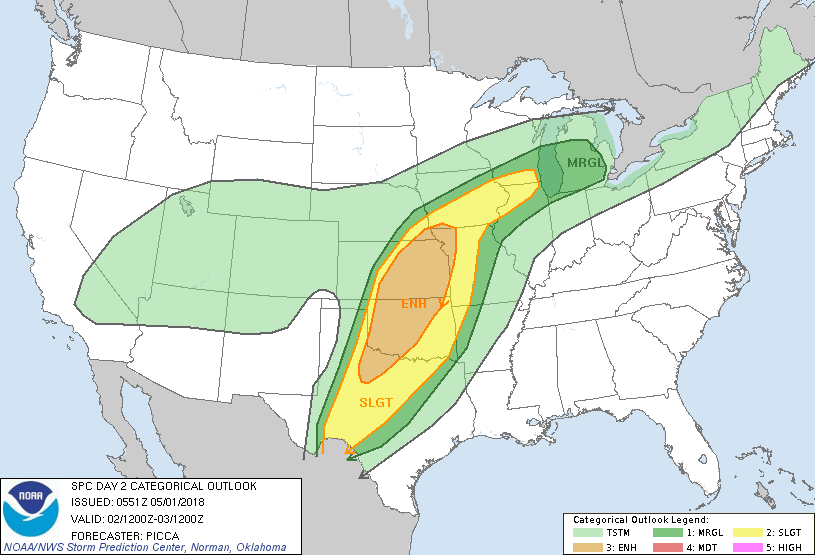 Thursday will be our best day in terms of seeing localized severe storms as the cold front progresses eastward. Of course, the storm system will have weaened a bit, but we still need to mention the risk for severe weather. TIMING - Showers during the pre-dawn hours are likely, which may affect the morning commute to work and school. We get a break from the rain during the morning before a cluster of strong to severe storms develop in West Texas and move to the east. They should be in the region by about lunch time. THREATS - The main threat that comes out of this system comes from large hail to damaging straight-line winds. Some models suggest that a couple of tornadoes can't be ruled out as well. For those that don't see anything on Thursday, it should be mostly cloudy and dry with afternoon highs in the low 80s. FRIDAY AND THE WEEKEND - We generally clear out for the weekend, though we still could see a few stray showers during the weekend, but most places stay dry with highs in the low to mid 80s. Winds should turn out generally calm, and should be quite comfortable. The sky will be sunny. NEXT WEEK - It looks like most of next week will remain dry and pleasant with highs mostly in the mid 80s with sunshine in full force. See the Texas Weather Discussion Video for more details. 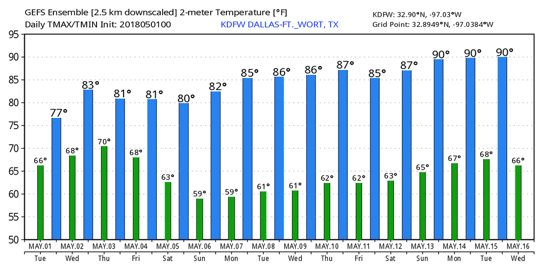 about the authorDonovan Neal is one of the most trusted and recognized meteorologist and storm specialist in his community and school. He currently holds two Advanced Storm Spotter Training Certificates and is a NOAA Weather-Ready Nation Ambassador. |
Archives
March 2023
Categories |
 RSS Feed
