
|
TODAY - As the ridge continues to build over Texas, our days will continue to look the same; hot and windy days with fair nights. The high this afternoon will be in the mid upper 90s. Not much change in the forecast tomorrow. We continue to forecast sunshine in full force with breezy conditions. Highs will be in the upper 90s. THE WEEKEND - Saturday will be the hottest day of the year so far with a projected high of 104-105, which could be our new record high, replacing our current record of 100, set in 1998. A cold front comes through Saturday evening, and we will mention the chance of a few isolated showers and thunderstorms along the front. I would not be surprised if we see a few strong to severe storms Saturday evening/night taking into account the daytime heating we will have. Places that do not see rain will likely see an increase of cloud coverage during the evening into the overnight hours. Heat levels cool down a bit with afternoon highs in the mid 90s. NEXT WEEK - Most of next week stays dry. However, an area of low pressure followed by a dryline will set up in West Texas. A complex of showers and thunderstorms may develop along that boundary Tuesday afternoon that could move eastward towards DFW. A few isolated showers and storms will be mentioned. Highs will stay in the upper 90s to low 100s with more sun than clouds. See the Texas Weather Discussion Video for more details. 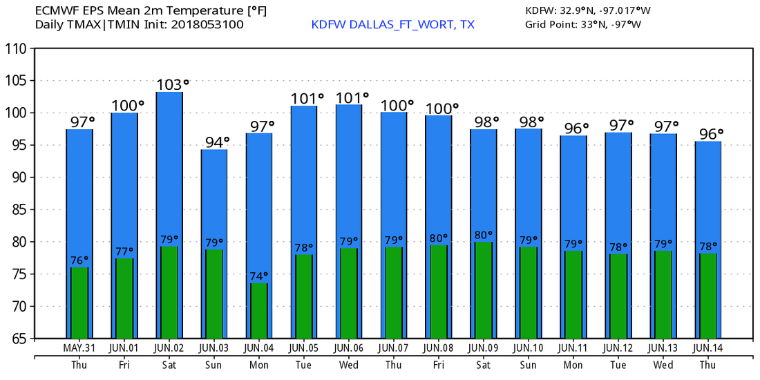 TROPICS - All is quiet in the Atlantic Basin, and tropical cyclone development is not expected within the next two to five days. Tomorrow marks the first day of Meteorological summer as well as the start of the 2018 Atlantic Hurricane Season.
|
Archives
March 2023
Categories |
 RSS Feed
