
|
FREEZING START - As advertised, temperatures are currently in the upper 20s to low 30s this morning. DFW's official low now is 31°, which is just two degrees shy of the record low of 29° for November 13. With much drier air than expected filtering into North Texas, all of the roads are fine, so no icy conditions anywhere is expected today. However, do bring the heavy coat, hat, and gloves. Although highs will be in the upper 30s/low 40s, the wind chill will make it feel 10-20 degrees cooler with a northerly wind. Morning lows tomorrow will be in the mid to upper 20s, and the record low for DFW on November 14 is 29°, set in 1959. At this point, we are on track to surpassing that with a raw, cold airmass in place. Highs will only get to the mid 40s tomorrow with a mostly sunny sky once again. WEDNESDAY THROUGH FRIDAY - Not much change. We gradually get warmer each day with sunshine in full force everyday. Highs will be in the mid 40s on Wednesday, followed by highs in the mid 50s by Thursday and low 60s by Friday. We will likely start each morning below freezing until we get to Friday, which we will start in the upper 30s. THE WEEKEND - Saturday will be dry for most with highs in the low 60s with mostly sunny skies. A cold front comes through early Sunday morning which will being clouds and highs in the low to mid 50s with mostly cloudy skies. We might see a shower or two ahead of the front. THANKSGIVING WEEK - For now, most of Thanksgiving week looks mostly dry with more clouds than sun on most days. Highs will mostly be in the upper 50s to low 60 degree range for most communities during the week. See the Texas Weather Discussion Video for more details. 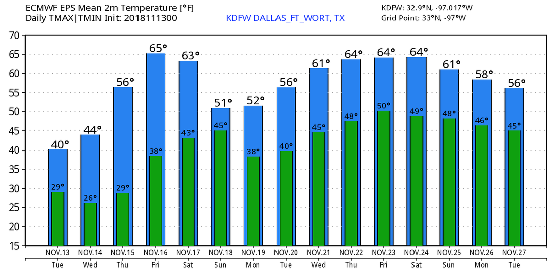 TROPICS - A disturbance on top of the Leeward Islands still has a 40% chance of development, but won't develop anytime soon due to non-conducive environment. Even if it does develop, it should recurve into the Atlantic well before getting close to the US.
|
Archives
March 2023
Categories |
 RSS Feed
